|
|
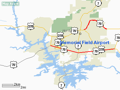
Memorial Field Airport
Hot Springs Memorial Field Airport |
 |
| IATA: HOT – ICAO: KHOT – FAA LID: HOT |
| Summary |
| Airport type |
Public |
| Owner |
City of Hot Springs |
| Location |
Hot Springs, Arkansas |
| Elevation AMSL |
540 ft / 165 m |
| Coordinates |
34°28′41″N 093°05′46″W / 34.47806°N 93.09611°W / 34.47806; -93.09611 |
| Website |
HotSpringsAirport.net |
| Runways |
| Direction |
Length |
Surface |
| ft |
m |
| 5/23 |
6,595 |
2,010 |
Asphalt |
| 13/31 |
4,099 |
1,249 |
Asphalt |
| Statistics (2006) |
| Aircraft operations |
42,622 |
| Based aircraft |
128 |
| Source: Federal Aviation Administration |
Memorial Field Airport (IATA: HOT, ICAO: KHOT, FAA LID: HOT), also known as Hot Springs Memorial Field Airport, is a public airport located three miles (5 km) southwest of the central business district of Hot Springs, a city in Garland County, Arkansas, United States. It also serves nearby Hot Springs National Park. Airport Director George Downie has been over HOT since the early 1990s. Glen Barentine, Airport Operations Manger, has been at HOT since 2002.
The airport is currently used for general aviation only. Commercial service is subsidized by the Essential Air Service program.
Fifteen retired Atlantic Southeast Airlines Embraer 120s are stored here. Facilities and aircraft
Memorial Field covers an area of 844 acres (342 ha) which contains two asphalt paved runways: 5/23 measuring 6,595 x 150 ft (2,010 x 46 m) and 13/31 at 4,099 x 100 ft (1,249 x 46 m).
For the 12-month period ending July 18, 2006, the airport had 42,622 aircraft operations, an average of 116 per day: 85% general aviation, 14% air taxi and 1% military. There are 128 aircraft based at this airport: 52% single engine, 44% multi-engine and 5% jet aircraft.
Airlines and destinations
| Airlines |
Destinations |
| SeaPort Airlines |
Memphis |
The above content comes from Wikipedia and is published under free licenses – click here to read more.
Location
& QuickFacts
|
FAA Information Effective: |
2005-10-27 |
|
Airport Identifier: |
HOT |
|
Longitude/Latitude: |
093-05-46.3500W/34-28-40.9220N
-93.096208/34.478034 (Estimated) |
|
Elevation: |
540
ft / 164.59 m (Surveyed) |
|
Land: |
844 acres |
|
From nearest city: |
3
nautical miles SW of Hot Springs, AR |
|
Location: |
Garland County, AR |
|
Magnetic Variation: |
04E
(1985) |
Owner &
Manager
|
Ownership: |
Publicly owned |
|
Owner: |
City
Of Hot Springs |
|
Address: |
Po
Box 700
Hot
Springs, AR 71902 |
|
Phone number: |
501-321-6800 |
|
Manager: |
George Downie |
|
Address: |
525
Airport Road
Hot
Springs, AR 71913 |
|
Phone number: |
501-321-6750 |
Airport
Operations and Facilities
|
Airport Use: |
Open to public |
|
Wind indicator: |
Yes |
|
Segmented Circle: |
Yes |
|
Control Tower: |
No |
|
Attendance Schedule: |
ALL/ALL/0500-2200 |
|
Lighting Schedule: |
DUSK-DAWN
ACTVT HIRL RY 05/23; MIRL RY 13/31; MALSR RY 05; PAPI RY 23 &
REIL RY 13 - CTAF. |
|
Beacon Color: |
Clear-Green
(lighted land airport) |
|
Landing fee charge: |
No |
|
Sectional chart: |
Memphis |
|
Region: |
ASW
- Southwest |
|
Boundary ARTCC: |
ZME - Memphis |
|
Tie-in FSS: |
JBR
- Jonesboro |
|
FSS on Airport: |
No |
|
FSS Phone: |
870-935-3471 |
|
FSS Toll Free: |
1-800-WX-BRIEF |
|
NOTAMs Facility: |
HOT
(NOTAM-d service avaliable) |
|
Certification type/date: |
LU
5/1973
CLSD TO UNSKED ACR OPNS WITH MORE THAN 30 PSGR SEATS EXCP PPR CALL
AMGR 501-321-6750.
ARFF NOT AVAIL 2200-0500. |
|
Federal Agreements: |
NGY3 |
Airport
Communications
|
CTAF: |
123.000 |
|
Unicom: |
123.000 |
Airport
Services
|
Fuel available: |
100LLA
FOR FUEL AFT HRS CALL 501-609-1242 OR 501-617-4908. |
|
Airframe Repair: |
MAJOR |
|
Power Plant Repair: |
MAJOR |
|
Bottled Oxygen: |
NONE |
|
Bulk Oxygen: |
NONE |
Runway
Information
Runway
05/23
|
Dimension: |
6595
x 150 ft / 2010.2 x 45.7 m |
|
Surface: |
ASPH,
Fair Condition |
|
Surface Treatment: |
Saw-cut or plastic Grooved |
|
Weight Limit: |
Single
wheel: 75000 lbs.
Dual wheel: 125000 lbs.
Dual tandem wheel: 210000 lbs.
Dual dual tandem wheel: 400000 lbs. |
|
Edge Lights: |
High |
|
|
Runway 05 |
Runway 23 |
|
Longitude: |
093-06-22.5490W |
093-05-18.5920W |
|
Latitude: |
34-28-22.8880N |
34-29-00.9760N |
|
Elevation: |
501.00
ft |
540.00
ft |
|
Alignment: |
54 |
127 |
|
ILS Type: |
ILS/DME
|
|
|
Traffic Pattern: |
Right |
Left |
|
Markings: |
Precision
instrument, Fair Condition |
Precision
instrument, Fair Condition |
|
Crossing Height: |
0.00 ft |
49.00 ft |
|
Displaced threshold: |
0.00
ft |
490.00
ft |
|
VASI: |
|
4-light PAPI on left side |
|
Visual Glide Angle: |
0.00° |
3.00° |
|
Approach lights: |
MALSR |
|
|
Obstruction: |
,
50:1 slope to clear |
92 ft pole, 1400.0 ft from runway, 650 ft right of
centerline, 13:1 slope to clear
APCH RATIO 30:1 TO DSPLCD THLD +82 FT OBSTRUCTION LGTD POLE
2500 FT FM DSPLCD THLD 300 FT RIGHT. |
|
Decleard distances: |
Take off run available 6595.00 ft
Take off distance available 6595.00 ft
Actual stop distance available 6595.00 ft
Landing distance available 6595.00 ft |
Take off run available 6595.00 ft
Take off distance available 6595.00 ft
Actual stop distance available 6595.00 ft
Landing distance available 6105.00 ft |
|
Runway
13/31
|
Dimension: |
4099
x 150 ft / 1249.4 x 45.7 m |
|
Surface: |
ASPH,
Fair Condition |
|
Weight Limit: |
Single wheel: 28000 lbs.
Dual wheel: 36000 lbs.
Dual
tandem wheel: 63000 lbs. |
|
Edge Lights: |
Medium |
|
|
Runway 13 |
Runway 31 |
|
Longitude: |
093-05-57.1170W |
093-05-22.0590W |
|
Latitude: |
34-28-53.5160N |
34-28-25.2190N |
|
Elevation: |
520.00
ft |
505.00
ft |
|
Alignment: |
127 |
127 |
|
Traffic Pattern: |
Right |
Left |
|
Markings: |
Basic, Good Condition |
Basic, Good Condition |
|
Runway End Identifier: |
Yes |
|
|
Obstruction: |
25 ft trees, 600.0 ft from runway, 150 ft left of centerline,
16:1 slope to clear |
121 ft pole, 3200.0 ft from runway, 300 ft right of
centerline, 24:1 slope to clear |
|
Decleard distances: |
Take off run available 4099.00 ft
Take off distance available 4099.00 ft
Actual stop distance available 4099.00 ft
Landing distance available 4099.00 ft |
Take off run available 4099.00 ft
Take off distance available 4099.00 ft
Actual stop distance available 4099.00 ft
Landing distance available 4099.00 ft |
|
Radio Navigation
Aids
|
ID |
Type |
Name |
Ch |
Freq |
Var |
Dist |
|
HO |
NDB |
Hossy |
|
385.00 |
04E |
5.7
nm |
|
MVQ |
NDB |
Malvern |
|
215.00 |
04E |
18.7
nm |
|
ADF |
NDB |
Arkadelphia |
|
275.00 |
02E |
25.4
nm |
|
MPJ |
NDB |
Morrilton |
|
410.00 |
07E |
39.4
nm |
|
BDQ |
NDB |
Bridge |
|
208.00 |
04E |
44.0
nm |
|
RUE |
NDB |
Russellville |
|
379.00 |
03E |
46.8
nm |
|
CWS |
NDB |
Conway |
|
302.00 |
05E |
49.2
nm |
|
HOT |
VOR/DME |
Hot
Springs |
037X |
110.00 |
04E |
0.3
nm |
|
LIT |
VORTAC |
Little
Rock |
086X |
113.90 |
05E |
46.9
nm |
Memorial Field Airport
Address:
Garland County, AR
Tel: 501-321-6750
|
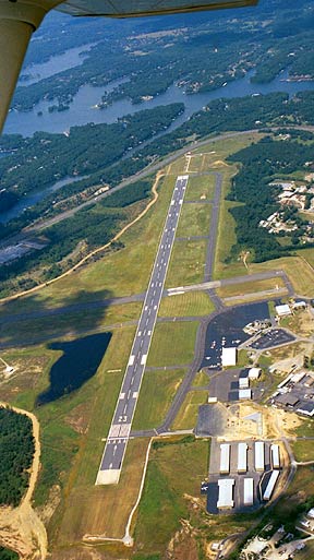
Shot from the northeast side
over the city of Hot Springs AR. Looking southwest over Lake Hamilton.
Photo by the crew from Tallyho Flight Training Inc. |
Images
and information placed above are from
http://www.airport-data.com/airport/HOT/
http://www.airstripamerica.com/cgi-bin/apt_info?HOT
We
thank them for the data!
|
General Info |
| Country |
United
States |
| State |
ARKANSAS
|
| FAA
ID |
HOT
|
| Latitude |
34-28-40.922N
|
| Longitude |
093-05-46.350W
|
| Elevation |
540
feet |
| Near
City |
HOT
SPRINGS |
We don't guarantee the information is fresh and accurate. The data may be wrong or outdated.
For more up-to-date information please refer to other sources.
|
|