 |
|
Drake Field
Fayetteville Executive Airport |
| IATA: FYV – ICAO: KFYV – FAA LID: FYV |
| Summary |
| Airport type |
Public |
| Owner |
City of Fayetteville |
| Serves |
Fayetteville, Arkansas |
| Elevation AMSL |
1,251 ft / 381 m |
| Coordinates |
36°00′18″N 094°10′12″W / 36.005°N 94.17°W / 36.005; -94.17 |
| Runways |
| Direction |
Length |
Surface |
| ft |
m |
| 16/34 |
6,006 |
1,831 |
Asphalt |
| Statistics (2009) |
| Aircraft operations |
35,267 |
| Based aircraft |
85 |
| Source: Federal Aviation Administration |
Drake Field (IATA: FYV, ICAO: KFYV, FAA LID: FYV) is a city-owned public-use airport located three nautical miles (6 km) south of the central business district of Fayetteville, in Washington County, Arkansas, United States. It is also known as Fayetteville Executive Airport and was formerly known as Fayetteville Municipal Airport. History
Drake Field served as the commercial airport for Northwest Arkansas until the opening of the Northwest Arkansas Regional Airport (XNA) in Highfill, Arkansas.
Facilities and aircraft
The airport covers an area of 631 acres (255 ha) at an elevation of 1,251 feet (381 m) above mean sea level. It has one runway designated 16/34 with an asphalt surface measuring 6,006 by 100 feet (1,831 x 30 m).
For the 12-month period ending April 30, 2009, the airport had 35,267 aircraft operations, an average of 96 per day: 97% general aviation, 2% air taxi, 1% military, and <1% scheduled commercial. At that time there were 85 aircraft based at this airport: 81% single-engine, 8% multi-engine, 9% jet and 1% helicopter.
The above content comes from Wikipedia and is published under free licenses – click here to read more.
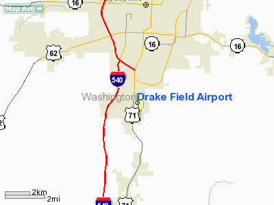
Location
& QuickFacts
| FAA
Information Effective: |
2005-10-27 |
| Airport
Identifier: |
FYV |
| Longitude/Latitude: |
094-10-12.2050W/36-00-18.3410N
-94.170057/36.005095 (Estimated) |
| Elevation: |
1251
ft / 381.30 m (Surveyed) |
| Land: |
631
acres |
| From
nearest city: |
3
nautical miles S of Fayetteville, AR |
| Location: |
Washington
County, AR |
| Magnetic
Variation: |
05E
(1985) |
Owner &
Manager
| Ownership: |
Publicly
owned |
| Owner: |
City
Of Fayetteville |
| Address: |
113
Mountain St
Fayetteville, AR 72701 |
| Phone
number: |
479-575-8330 |
| Manager: |
Ray
Boudreaux
DIRECTOR, AVIATION & ECONOMIC DEVELOPMENT. |
| Address: |
4500
S School Suite A
Fayetteville, AR 72701 |
| Phone
number: |
479-718-7642 |
Airport
Operations and Facilities
| Airport
Use: |
Open
to public |
| Wind
indicator: |
Yes |
| Segmented
Circle: |
No |
| Control
Tower: |
Yes |
| Attendance
Schedule: |
ALL/MON-FRI/0600-2200,ALL/SAT-SUN/0800-2000
FOR SVC AFT HRS CTC 479-601-5753. |
| Lighting
Schedule: |
DUSK-DAWN
WHEN ATCT CLSD MIRL RY 16/34 PRESET MED INTST. ACTVT ODALS
RYS 16 & 34 - CTAF. |
| Beacon
Color: |
Clear-Green
(lighted land airport) |
| Landing
fee charge: |
No |
| Sectional
chart: |
Kansas
City |
| Region: |
ASW
- Southwest |
| Traffic
Pattern Alt: |
849
ft |
| Boundary
ARTCC: |
ZME
- Memphis |
| Tie-in
FSS: |
JBR
- Jonesboro |
| FSS
on Airport: |
No |
| FSS
Phone: |
870-935-3471 |
| FSS
Toll Free: |
1-800-WX-BRIEF |
| NOTAMs
Facility: |
FYV
(NOTAM-d service avaliable) |
| Certification
type/date: |
LU
5/1973
CLSD TO ACR OPNS WITH MORE THAN 30 PSGR SEATS EXCP 24 HR PPR; CALL
AMGR 479-718-7642 OR FAX REQ TO 479-718-7646. |
| Federal
Agreements: |
NGY |
Airport
Communications
| CTAF: |
128.000 |
| Unicom: |
122.950
|
Airport
Services
| Fuel
available: |
100LLA
MOGAS
FOR FUEL AFT HRS CALL 479-718-7641; FEE CHARGED. |
| Airframe
Repair: |
MINOR |
| Power
Plant Repair: |
MINOR |
| Bulk
Oxygen: |
NONE |
Runway
Information
Runway
16/34
| Dimension: |
6006
x 100 ft / 1830.6 x 30.5 m |
| Surface: |
ASPH,
Good Condition |
| Surface
Treatment: |
Saw-cut
or plastic Grooved |
| Weight
Limit: |
Single
wheel: 90000 lbs.
Dual wheel: 150000 lbs.
Dual tandem wheel: 175000 lbs. |
| Edge
Lights: |
Medium |
| |
Runway
16 |
Runway
34 |
| Longitude: |
094-10-19.2130W |
094-10-05.1990W |
| Latitude: |
36-00-47.4840N |
35-59-49.1970N |
| Elevation: |
1250.00 ft |
1237.00 ft |
| Alignment: |
127 |
127 |
| ILS
Type: |
LOC/DME
|
LDA/DME
|
| Traffic
Pattern: |
Left |
Left |
| Markings: |
Precision
instrument, Good Condition |
Precision
instrument, Good Condition |
| Crossing
Height: |
50.00
ft |
0.00
ft |
| VASI: |
4-light
PAPI on left side |
|
| Visual
Glide Angle: |
3.00° |
0.00° |
| Approach
lights: |
ODALS |
ODALS |
| Obstruction: |
19
ft road, 200.0 ft from runway, 300 ft right of centerline
18 FT ROAD & +5 FT FENCE 0-200 FT FM RY END 341 FT R. |
263
ft tree, 5585.0 ft from runway, 958 ft right of centerline,
20:1 slope to clear |
| Decleard
distances: |
Take
off run available 6006.00 ft
Take off distance available 6006.00 ft
Actual stop distance available 6006.00 ft
Landing distance available 6006.00 ft |
Take
off run available 6006.00 ft
Take off distance available 6006.00 ft
Actual stop distance available 6006.00 ft
Landing distance available 6006.00 ft |
|
Radio Navigation
Aids
| ID |
Type |
Name |
Ch |
Freq |
Var |
Dist |
| SLG |
NDB |
Siloam
Springs |
|
284.00 |
04E |
19.0
nm |
|
TQH |
NDB |
Tahlequah |
|
215.00 |
05E |
40.9
nm |
| IQS |
NDB |
Sallisaw |
|
520.00 |
05E |
47.5
nm |
|
CZE |
NDB |
Clarksville |
|
201.00 |
04E |
48.6
nm |
| DAK |
VOR/DME |
Drake |
025X |
108.80 |
07E |
2.6
nm |
|
RZC |
VORTAC |
Razorback |
111X |
116.40 |
04E |
14.7
nm |
| FSM |
VORTAC |
Fort
Smith |
041X |
110.40 |
07E |
37.4
nm |
Remarks
Drake Field Airport
Address: Washington
County, AR
Tel: 479-718-7642
Images and information placed
above are from
http://www.airport-data.com/airport/FYV/
We
thank them for the data!
|
General Info |
| Country |
United
States |
| State |
ARKANSAS
|
| FAA
ID |
FYV
|
| Latitude |
36-00-18.341N
|
| Longitude |
094-10-12.205W
|
| Elevation |
1251
feet |
| Near
City |
FAYETTEVILLE
|
We don't guarantee the information is fresh and accurate. The data may be wrong or outdated.
For more up-to-date information please refer to other sources.
|
|


