|
 |
|
||||
|
History and Overview of YCAA
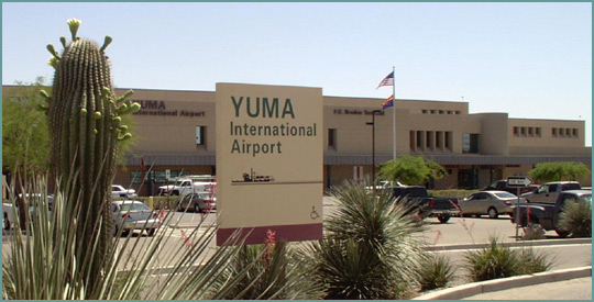
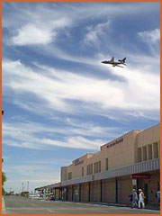
While the Authority is incorporated as a non-profit entity, it also has been designated as a governmental entity by Arizona Revised Statute Section 28-8411 et seq. In accordance with the Authority's status as a governmental entity it is not subject to income or property taxes and has the ability to issue tax exempt debt. FC "Frosty" Braden Passenger Terminal
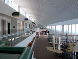
Visitors to our Airport will find four automobile rental agencies, a restaurant and lounge, a gift shop and a game room in addition to the two commercial airlines. The FC "Frosty" Braden Passenger Terminal is proud to display a collection of art which was funded through donations from the public. Other features of the Terminal building include a business center open to the public and wireless internet service available from anywhere within the building. The Yuma County Airport Authority works hard to ensure that your experience in our airport is an enjoyable one. If you are happy with the facility and services provided please tell others. If not, please tell us by contacting Airport Administration. |
|||||||||||||||||||||||||||||||||||||||||||||||||||||||||||||||||||||||||||||||||||||||||||||||||||||||||||||||||||||||||||||||||||||||||||||||||||||||||||||||||||||||||||||||||||||||||||||||||||||||||||||||||||||||||||||||||||||||||||||||||||||||||||||||||||||||||||||||||||||||||||||||||||||||||||||||||||||||||||||||||||||||||||||||||||||||||||||||||||||||||||||||||||||||||||||||||||||||||||||||||||||||||||
|
FAA Information Effective: |
2005-10-27 |
| Airport Identifier: |
YUM |
| Longitude/Latitude: |
114-36-21.5000W/32-39-23.7000N |
| Elevation: |
216 ft / 65.84 m (Surveyed) |
| Land: |
3100 acres |
| From nearest city: |
3 nautical miles S of Yuma, AZ |
| Location: |
Yuma County, AZ |
| Magnetic Variation: |
13E (2000) |
|
Ownership: |
Navy owned |
| Owner: |
Yuma County And U S Navy |
| Address: |
2191 E 32nd St |
| Phone number: |
928-726-5882 |
| Manager: |
David Gaines |
| Address: |
2191 E 32nd St |
| Phone number: |
928-726-5882 |
| Wind indicator: |
Yes |
| Segmented Circle: |
No |
| Control Tower: |
Yes |
| Attendance Schedule: |
ALL/ALL/ALL,CLSD HOL |
| Lighting Schedule: |
DUSK-DAWN |
| Beacon Color: |
Clear-Green (lighted land airport) |
| Landing fee charge: |
No |
| Sectional chart: |
Phoenix |
| Region: |
AWP - Western-Pacific |
| Boundary ARTCC: |
ZLA - Los Angeles |
| Tie-in FSS: |
PRC - Prescott |
| FSS on Airport: |
No |
| FSS Phone: |
928-778-7810 |
| FSS Toll Free: |
1-800-WX-BRIEF |
| NOTAMs Facility: |
YUM (NOTAM-d service avaliable) |
| Certification type/date: |
?? 5/1973 |
| Federal Agreements: |
NGSY3 |
|
CTAF: |
119.300 |
|
Unicom: |
122.950 |
|
Fuel available: |
100 A |
|
Airframe Repair: |
MAJOR |
|
Power Plant Repair: |
MAJOR |
| Bottled Oxygen: |
HIGH/LOW |
| Bulk Oxygen: |
HIGH/LOW |
|
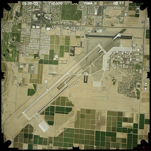
Dimension: |
13300 x 200 ft / 4053.8 x 61.0 m |
||||||||||||||||||||||||||||||||||||||||||
| Surface: |
CONC, Good Condition |
||||||||||||||||||||||||||||||||||||||||||
| Weight Limit: |
Single
wheel: 103000 lbs. |
||||||||||||||||||||||||||||||||||||||||||
| Edge Lights: |
High |
||||||||||||||||||||||||||||||||||||||||||
|
|||||||||||||||||||||||||||||||||||||||||||
|
Dimension: |
9241 x 150 ft / 2816.7 x 45.7 m |
|||||||||||||||||||||||||||||||||||||||
| Surface: |
ASPH-CONC, Good Condition |
|||||||||||||||||||||||||||||||||||||||
| Weight Limit: |
Single
wheel: 162000 lbs. |
|||||||||||||||||||||||||||||||||||||||
| Edge Lights: |
High |
|||||||||||||||||||||||||||||||||||||||
|
||||||||||||||||||||||||||||||||||||||||
|
Dimension: |
6146 x 150 ft / 1873.3 x 45.7 m |
|||||||||||||||||||||||||||||||||
| Surface: |
ASPH-CONC, Good Condition |
|||||||||||||||||||||||||||||||||
| Weight Limit: |
Single
wheel: 63000 lbs. |
|||||||||||||||||||||||||||||||||
| Edge Lights: |
High |
|||||||||||||||||||||||||||||||||
|
||||||||||||||||||||||||||||||||||
|
Dimension: |
5711 x 150 ft / 1740.7 x 45.7 m |
||||||||||||||||||||||||||||||||||||||||||
| Surface: |
ASPH-CONC, Good Condition |
||||||||||||||||||||||||||||||||||||||||||
| Weight Limit: |
Single
wheel: 72000 lbs. |
||||||||||||||||||||||||||||||||||||||||||
| Edge Lights: |
High |
||||||||||||||||||||||||||||||||||||||||||
|
|||||||||||||||||||||||||||||||||||||||||||
|
ID |
Type |
Name |
Ch |
Freq |
Var |
Dist |
| OEG |
NDB |
Golden Eagle |
|
413.00 |
12E |
14.5 nm |
| NYL |
TACAN |
Yuma |
084X |
|
14E |
0.7 nm |
| MXL |
VOR/DME |
Mexicali |
097X |
115.00 |
14E |
31.3 nm |
| BZA |
VORTAC |
Bard |
115X |
116.80 |
14E |
6.7 nm |
| IPL |
VORTAC |
Imperial |
106X |
115.90 |
14E |
46.0 nm |
|
Aircraft based on field: |
189 |
| Single Engine Airplanes: |
104 |
| Multi Engine Airplanes: |
35 |
| Helicopters: |
8 |
| Military: |
42 |
| Sky West Airlines |
100.0% |
|
Los Angeles Intl (LAX) |
99.7% |
|
Palm Springs International (PSP) |
0.3% |
|
N270YV |
4.8% |
|
N560SW |
4.5% |
|
N293SW |
4.5% |
|
N233SW |
3.4% |
|
N223SW |
3.4% |
|
N294SW |
2.8% |
|
N290SW |
2.8% |
|
N250YV |
2.8% |
|
N564SW |
2.6% |
|
N292UX |
2.6% |
|
Aircraft Operations: |
433/Day |
| Air Taxi: |
3.5% |
| General Aviation Local: |
22.9% |
| General Aviation Itinerant: |
18.7% |
| Military: |
54.9% |
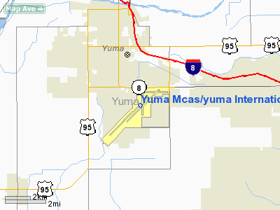
 Yuma Mcas/yuma International Airport
Contact Information
Yuma International Airport
2191 E. 32nd St. Suite 218
Yuma, AZ 85365
Phone: (928) 726-5882
Fax: (928) 344-4677
Office Hours:
Monday through Friday 8 AM - 5 PM
Office Closed on National Holidays
Terminal hours:
Open 7 days a week, 4:30 AM to 10:30 PM
Airport Operations are available 24/7/365
Office: 928-726-5882 ext. 160
Emergencies:
Cell Phone: 928-941-2396
Duty Pager: 928-376-5868
E-mail: ycaa@yumainternationalairport.com
URL: http://yumainternationalairport.com/
 |
(Click on the photo to
enlarge) |
http://www.airport-data.com/airport/YUM/
http://www.dot.state.az.us/aviation/airports/airports_list.asp?FAA=YUM
http://yumainternationalairport.com/
We thank them for the data!
| General Info | |
|---|---|
| Country | United States |
| State | ARIZONA |
| FAA ID | YUM |
| Latitude | 32-39-23.700N |
| Longitude | 114-36-21.500W |
| Elevation | 216 feet |
| Near City | YUMA |

 |
|
Copyright 2004-2026 © by Airports-Worldwide.com, Vyshenskoho st. 36, Lviv 79010, Ukraine Legal Disclaimer |
 The
Yuma International Airport is owned by Yuma County, Arizona and is managed
and operated by the Yuma County Airport Authority, Inc. ("the Authority").
The Authority was incorporated as a non-profit entity in the State of
Arizona on December 30, 1965, specifically for this purpose. The Authority
operates the Airport in accordance with a long term lease agreement with
Yuma County, Arizona. The Airport is managed by an Airport Director through
the guidance of a 14 member Board of Directors. The Authority concept
of management has allowed the Airport to provide and foster civil aviation
in the community without a financial burden being placed on the taxpayers
of Yuma County. The Authority is a self supporting entity generating the
revenue necessary to operate the airport through rates and charges assessed
directly to the users of the Airport.
The
Yuma International Airport is owned by Yuma County, Arizona and is managed
and operated by the Yuma County Airport Authority, Inc. ("the Authority").
The Authority was incorporated as a non-profit entity in the State of
Arizona on December 30, 1965, specifically for this purpose. The Authority
operates the Airport in accordance with a long term lease agreement with
Yuma County, Arizona. The Airport is managed by an Airport Director through
the guidance of a 14 member Board of Directors. The Authority concept
of management has allowed the Airport to provide and foster civil aviation
in the community without a financial burden being placed on the taxpayers
of Yuma County. The Authority is a self supporting entity generating the
revenue necessary to operate the airport through rates and charges assessed
directly to the users of the Airport.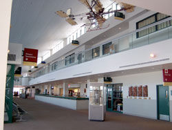 The
FC "Frosty" Braden Passenger Terminal at the Yuma International
Airport offers travelers the latest in airport amenities and comfort.
The $10 million Terminal building was completed in February of 1999 using
local contractors and financing provided through the Federal Aviation
Administration, the Arizona Department of Transportation and the issuance
of tax exempt bonds.
The
FC "Frosty" Braden Passenger Terminal at the Yuma International
Airport offers travelers the latest in airport amenities and comfort.
The $10 million Terminal building was completed in February of 1999 using
local contractors and financing provided through the Federal Aviation
Administration, the Arizona Department of Transportation and the issuance
of tax exempt bonds.