|
 |
|
||||
|
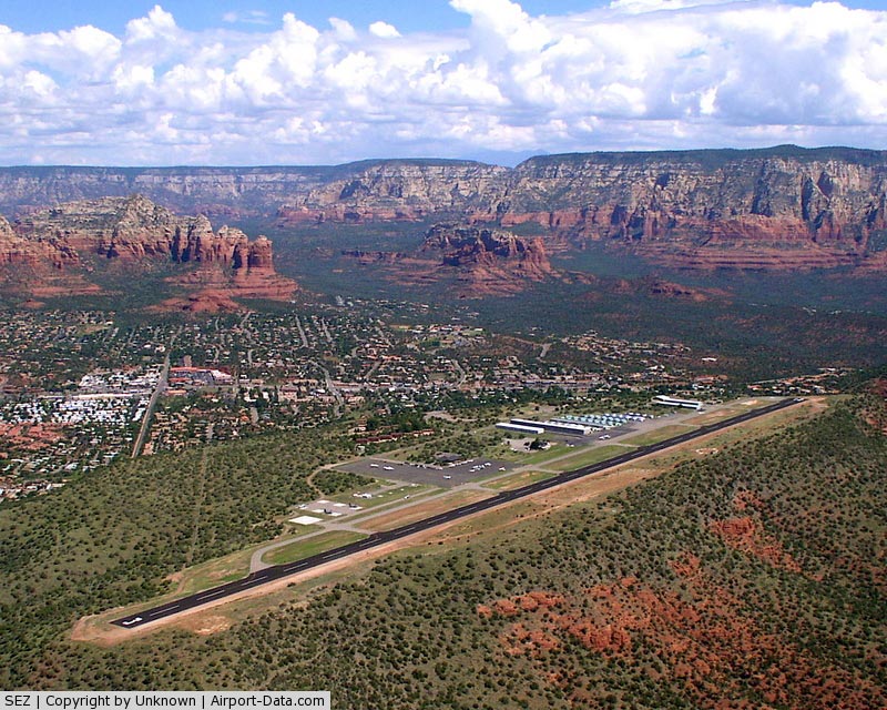
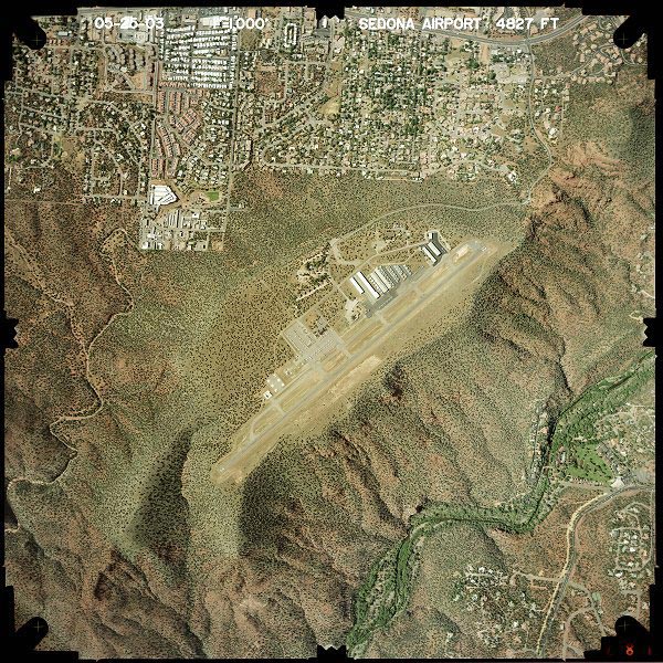
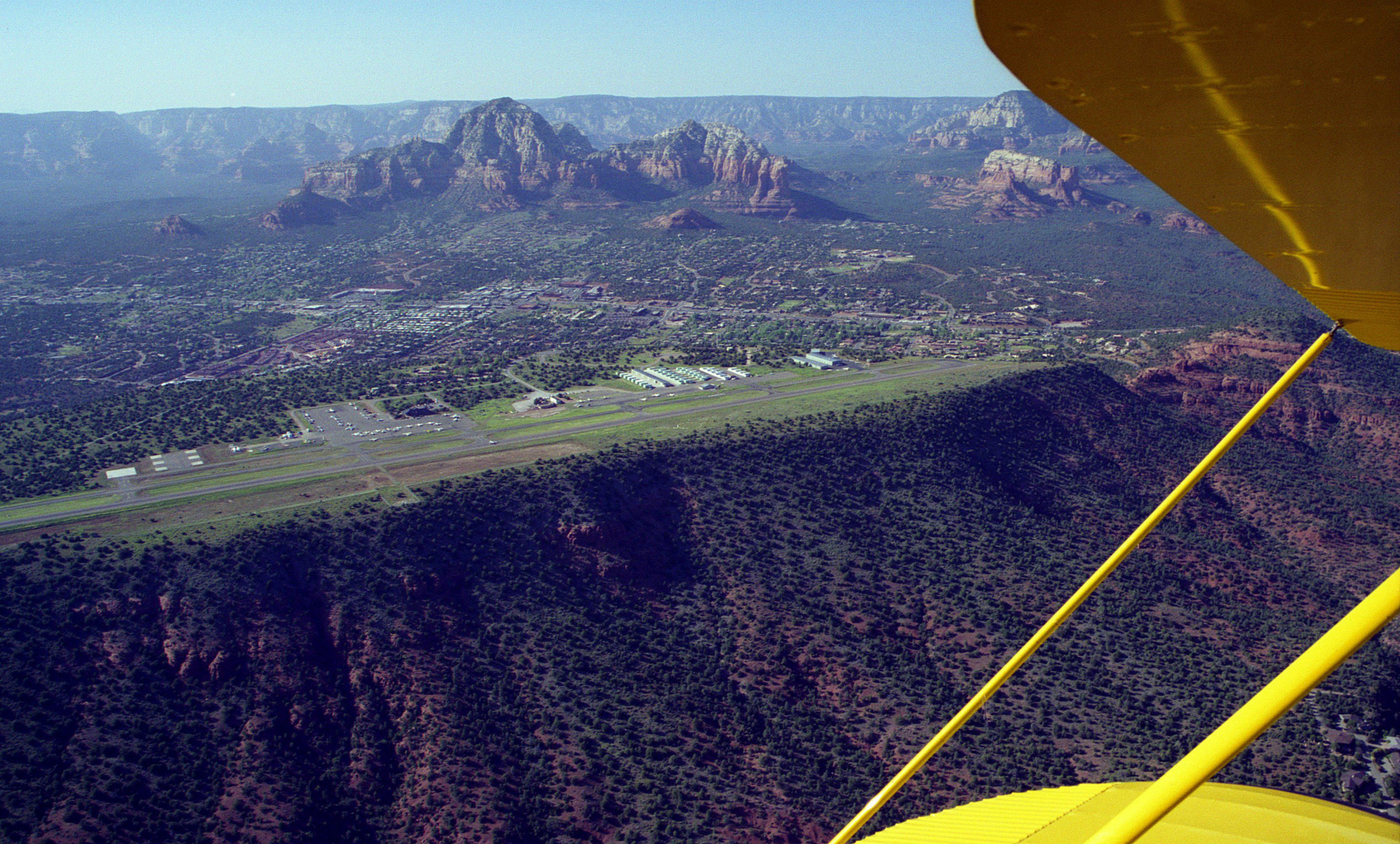
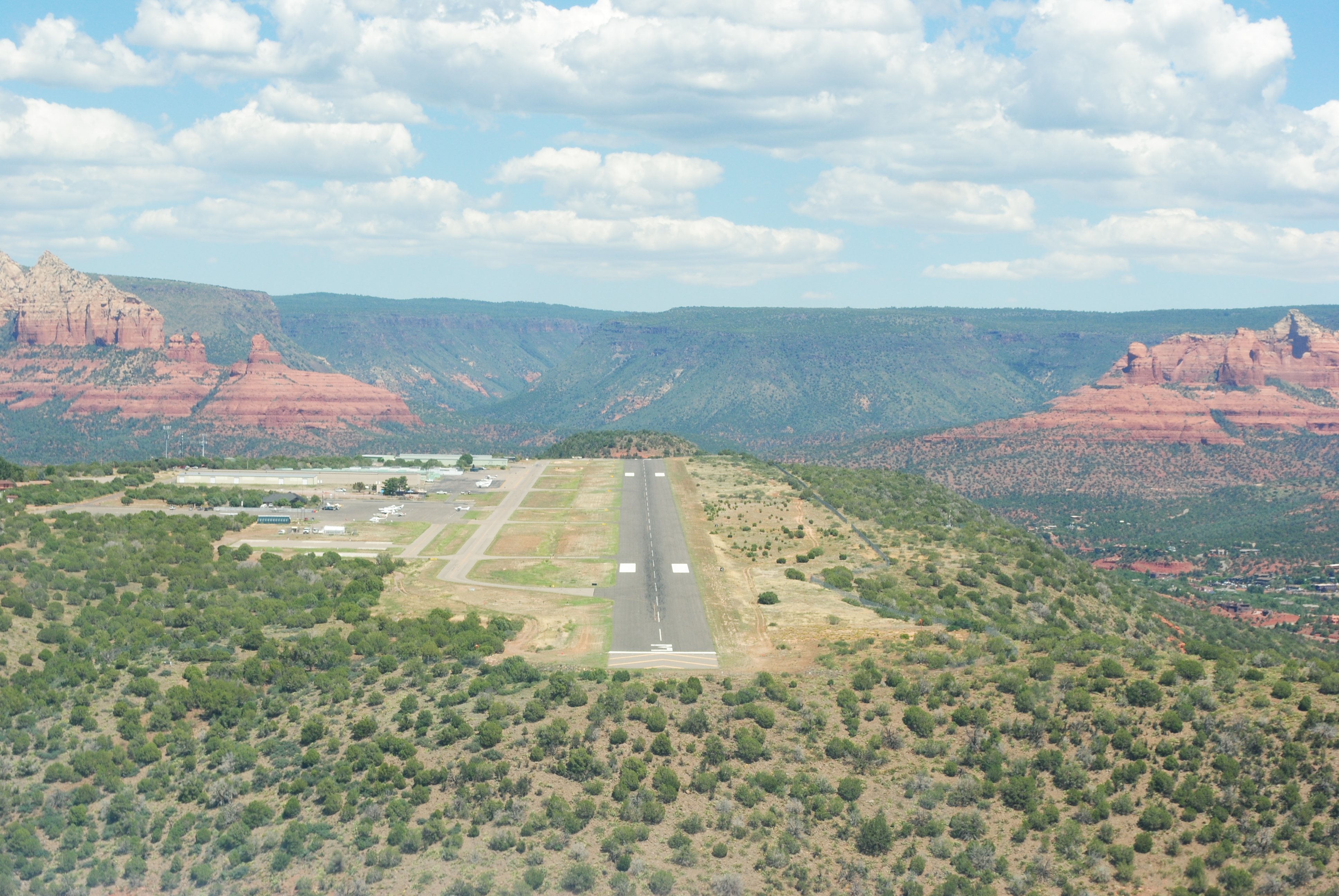
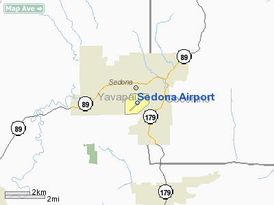
Sedona Airport (IATA: SDX, ICAO: KSEZ, FAA LID: SEZ) is a small non-towered airport located two miles (3 km) southwest of the central business district of Sedona, a city in Yavapai County, Arizona, United States. The airport covers 220 acres (89 ha) and has one runway and one helipad. Although most U.S. airports use the same three-letter location identifier for the FAA and IATA, Sedona Airport is assigned SEZ by the FAA and SDX by the IATA (which assigned SEZ to Seychelles International Airport in Mahé, Seychelles). Sedona is a very popular destination among Arizona tourists, especially with those who are interested in the New Age movement or those seeking to be close to nature. The airport is located on top of a high mesa overlooking a major portion of the city; it is not uncommon for tourists or locals driving around downtown Sedona to see an approaching airplane fly overhead and then suddenly disappear into the mountains without ever appearing to land. The airport is also located very close to the Red Rocks of Sedona. History
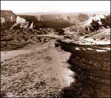
The airport was inaugurated in 1955. At that time it had no paved runway, and animals such as coyotes could be seen walking around the air-strip. This proved dangerous to pilots arriving at Sedona. By 1960, a small, paved runway had been built, practically eliminating the animal residents problem. By 1990, the airport's runway had been improved and it had begun to receive service from smaller scheduled airlines. It was the hub of Air Sedona, which served it from such places as Sky Harbor International Airport in Phoenix, Las Vegas, the nearby Grand Canyon airport and others. Sedona's airport is not able to accommodate commercial jets of the size of the Boeing 727 or larger. It does, however, attract a large number of smaller business jets and aircraft such as Cessna and Beech airplanes and helicopters. Scenic Airlines discontinued service at Sedona in April 1997. The above content comes from Wikipedia and is published under free licenses – click here to read more.
The History of Sedona Airport by Dr. David Allen On October 31, 1956, E. L. Peterson, the Acting Secretary of Agriculture, deeded the 230 acres on top of the Mesa and the easement for the road right of way to Yavapai County as a public airport in perpetuity. The transfer was approved by the Attorney General of the United States on February 6th, 1957. Later that year, the first Civil Aeronautics Administration (CAA) grant of $13,420 paved a 3,700-foot runway in a north-east to south-west direction, along with some aircraft parking space.
By 1963, Sedona had 10 churches, 14 restaurants, 21 motels and three private art galleries. The Forest Service welcomed 665,838 visitors that year. Along Grasshopper Flats (today’s West Sedona), the drilling of the first well by Carl Williams in 1953 had led to a real estate boom and the development of homes where there had been only ranches. Big Park had begun to open up when water was found there. On the Mesa, the runway was extended in 1968 to its present length of 5,130 feet. There was a lot of community bickering about the airport. Some citizens felt taxpayers money should not be used to run an airport that might diminish their property values; some were worried about the noise; and some pilots felt that the airport was not being managed properly. In his memoirs, “Red Rocks and Blue Skies,” Harner Selvidge describes coming to Sedona in 1969 and seeing on a motel TV screen a notice written by Jim Geary, a pilot and real estate broker who owned the Sedona TV cable system. “THERE WILL BE A MEETING ABOUT THE FUTURE OF THE AIRPORT, WEDNESDAY NIGHT, AT THE MASONIC TEMPLE. ALL THE KOOKS WILL BE OUT, SO BE SURE AND ATTEND.” Selvidge, an electronics engineer, real estate developer and pilot of repute, moved to Sedona later in 1969. He writes: “The county Supervisors were tired of constant bickering about the airport, and those of us who were pilots using it were apprehensive that they might chuck the whole thing in disgust.” So Selvidge, John Carruthers, and Mel Arthur incorporated the Sedona Oak Creek Airport Authority (SOCCA) and, according to Selvidge, “went to the Yavapai County Supervisors with a proposal that if they gave us a long-term lease for the Sedona Airport property, we would take this thorn out of their sides. They fell on our shoulders, and on January 18, 1971, enthusiastically signed the 25-year lease we drew up.”
Fourteen aircraft were based there permanently, as were numerous deer, coyotes, and occasionally cattle, which broke through the surrounding fence. According to Selvidge, SOCCA decided that the Airport Authority’s objective would be to provide a “quasi-governmental mechanism to permit private business to operate at the airport supplying services to local and transient aircraft owners. The Authority would not compete with them or operate any business itself.” John Carruthers started a Fixed Base Operation (FBO), whose income came from the sale of fuel, rental of parking spaces, maintenance of aircraft and sale of parts and supplies. Selvidge became President of SOCCA and tried to get some local business persons who were not pilots to be members of the group, but none had any continuing interest. So, then as now, the airport was run by pilots. Through the 1970’s, improvements were made in the airport facilities and hangars were built. Runway resurfacing, taxiway paving and enlarged apron parking areas for aircraft were financed by grants from the Federal Aviation Administration trust funds with much smaller matching funds from the State and from the local Airport Authority. By 1978, 35 planes were based at the airport and there was an average of 40 flight operations (landings + take-offs) per day (more than 12,000 operations a year), of which some 500 were charter flights. Carl Bliss had taken over Carruthers’ FBO. His Sedona Air Services, provided fuel, maintenance and car rentals. Robert Jackson rented space from him and provided charter service and flight instruction as Northern Arizona Aircraft. Jack Seeley operated Sedona Aircraft Center providing aircraft services, charters and flight instruction. In 1980, the population of Sedona was 5,319 and a lot of homes had been built in the Grasshopper Flats area. A Prescott man flew his Cessna into Sedona Airport at weekends, put a notice in the parking lot at the Overlook offering airplane rides for $9.50 per person and flew his tour passengers up the Canyon to Midgely Bridge and around the back of Thunder Mountain before returning to the airport. Jack Seeley recognized that 80% of his charter business was to and from Phoenix. In 1981, he started Air Sedona and flew three round trips to Phoenix, seven days a week. By 1983, he was carrying an average of 300 passengers per month in winter and about twice that number per month the rest of the year. In 1980, Peter McKiernan and Bert Blume arrived in Sedona from Hollywood, where they had been providing the helicopter action for the TV series “Air Wolf.” When the series wound down, they brought a Bell Jet Ranger helicopter to Sedona and started selling tours. They bought Carl Bliss’ FBO and marketed their helicopter tours from the Hollywood glamour perspective with little success. Their tour operation folded in 1984. The Airport Restaurant opened in 1981 as Stretch Madden’s Airport Restaurant, serving Mexican food. The opening of the restaurant began the tradition of the pilots’ coffee and tea tables, which still goes on today. Every morning at 7 a.m., a group of pilots gathers for morning coffee. Some fly in from Montezuma and Rimrock airports. In the afternoon at 3.30 p.m. an overlapping group gathers for iced tea. They shoot the breeze about airplanes and flying and aviation in general. Sky Ranch Lodge and Motel, with 35 units, opened for business in 1982 and has provided significant revenue for the Airport Authority ever since. It has now expanded to 94 units. As it is built on County owned land, the Lodge, in common with all other businesses on the Mesa, pays no property taxes. In 1982, Selvidge, now 74, decided to get into the FBO business because, as he describes in his book, “ I am tired of unpaved parking and taxiing areas, pavement with chuck holes, weeds and junk around the buildings, rickety hangars with unpaved floors, water getting in the fuel supply. The whole area is beginning to look like a slum.” Selvidge and Chuck Turek, a pilot, real estate developer and general contractor, formed a partnership called Sky Mountain Aviation and in March 1983 built an FBO facility with paved hangars, modern fuel facilities and paved access to paved taxiways. Because the County Supervisors signed their approval of the lease, they avoided paying sales taxes on their building materials and avoided county property taxes. Their operation was profitable until February 1, 1989 when the facility went up in flames. It was reconstructed by September 1989, this time with automatic sprinklers. In 1985, Prescott-based Golden Pacific Airlines joined in the commuter business. In 1986 and 1987, figures from the Sedona Airport Master Plan show almost 7,000 annual passenger enplanements from Sedona. Golden Pacific bowed out of Sedona in 1988. While this was going on in Sedona, Mingus Constructors of Cottonwood were working in the Grand Canyon to pipe water from Roaring Springs on the North Rim to the South Rim Village. The company used helicopters to take equipment, pipes and crew into and out of the Canyon each day. As the Grand Canyon project began to wind down in 1985 and the helicopters were needed less, Ray Bluff Jr., who was running the project, saw an opportunity in Sedona and began to operate helicopter tours at weekends, using the restaurant lobby as his box office. He called his company Arizona Helicopter Adventures.
In 1991, a barnstorming pilot, Steve Bowen, parked his Waco biplane at Red Rock Aviation and began selling tours. He did well, but left after a year. A young man named Eric Brunner, who worked for Bluff, became enamoured with biplanes and shortly afterwards he and his father, Larry, started Red Rock Biplanes and have expanded into most areas of aircraft services. The Sedona Airport Master Plan of 1992 gives examples of daily logs of aircraft operations. In February 1991, there were three helicopter take-offs and landings on a Saturday, eight on a Sunday and none during the week. In November 1991, there were five landings and take-offs on a Saturday, eight on a Sunday and one or two each weekday. In 1992, Bluff’s interests changed dramatically. He lost two helicopters, one in Deer Valley where he had a pilot school and one in Lake Powell, fortunately without fatalities. He decided to go back into the family business and went to work in Southern California, leaving one Jet Ranger in Sedona to carry on the tours. In California, he met Mel Cane, who operated a helicopter business out of Gillespie Field near San Diego. He talked to Cane about his helicopter operation in Sedona, hoping that Cane would buy him out. Cane looked around Sedona and made a business decision to start his own helicopter tour company. He called it Skydance Helicopters. In February 1993, Jack Seeley needed a break from the high stress commuter business and sold Air Sedona to Lake Powell Air Services, which was owned by Scenic Air, an arm of Sky West. Seeley had been using four- and six- passenger planes. The new management brought in nine-seater twin Piper Navahos and cut the number of round-trip flights to four daily. For whatever reasons, the number of passengers dwindled and, in August 1995, commuter service ended. In 1993–94, Sedona Oak Creek Airport Authority began doing business as Sedona Airport Administration and decided to take full control of the aviation fuel and hangar businesses on the Mesa. This was a radical change from their original objectives. They first bought out Bert Blume’s Sedona Air Services. Then they purchased Bluff’s FBO, continued the fueling facilities as Red Rock Aviation, and made an agreement with pilot Rich Geiger for him to keep on the Arizona Adventure Helicopter operations. Finally, they bought out Sky Mountain Aviation.
Sedona Airport began in 1955 through the incredible entrepreneurial spirit and determination of two men, Joe Moser and Ray Steele. With each decade since then, there have been significant changes in the services the airport provides to the aviation and local communities. Next month’s article will discuss these changes and the airport’s impact economically and environmentally on the communities. The author acknowledges the following who gave so generously and freely of their time and knowledge: The Sedona Historical Scociety and Edith Denton; Ray Bluff, Jr.; Dave Cobb; Lawrence ‘Bo’ Fox; Mac McCall; Geoffrey Roth; Jack Seeley; Ray Steele, and Harner Selvidge, through his memoirs “Red Rocks and Blue Skies.” Location & QuickFacts
Owner & Manager
Airport Operations and Facilities
Airport Communications
Airport Services
Runway InformationRunway 03/21
Helipad H1
Radio Navigation Aids
Remarks
Based Aircraft
Operational Statistics
Address:
Yavapai County,
AZ E-Mail: saa1@commspeed.net URL: http://airport.sedona.net/
Images and information placed above are from http://www.airport-data.com/airport/SEZ/ http://www.dot.state.az.us/aviation/airports/airports_list.asp?FAA=SEZ
http://www.redrockreview.com/august01/1story_aug.html
We don't guarantee the information is fresh and accurate. The data may be wrong or outdated. For more up-to-date information please refer to other sources. |
|||||||||||||||||||||||||||||||||||||||||||||||||||||||||||||||||||||||||||||||||||||||||||||||||||||||||||||||||||||||||||||||||||||||||||||||||||||||||||||||||||||||||||||||||||||||||||||||||||||||||||||||||||||||||||||||||||||||||||||||||||||||||||||||||||||||||||||||||||||||||||||||||||||||||||||||||||||||||||||||||||||||||||||||||

 |
|
Copyright 2004-2026 © by Airports-Worldwide.com, Vyshenskoho st. 36, Lviv 79010, Ukraine Legal Disclaimer |
 In 1958, four
aircrafts were based on the strip, including two Cessna 180’s of
Oak Creek Flying Services. The airport had one small hangar, runway lights
and a small rotating light beacon. A phone booth was set up with a dime
and the gas station phone number taped to it. Fishermen and hunters began
to fly in and several deer hunters got their bucks right smack on the
runway.
In 1958, four
aircrafts were based on the strip, including two Cessna 180’s of
Oak Creek Flying Services. The airport had one small hangar, runway lights
and a small rotating light beacon. A phone booth was set up with a dime
and the gas station phone number taped to it. Fishermen and hunters began
to fly in and several deer hunters got their bucks right smack on the
runway.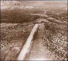 For a dollar
a year, SOCCA took control of the 230 acres on top of the Mesa. The airport
consisted of a paved runway, a paved parking area with two fuel pumps
and a shack for the attendant, the old decrepit hangar built in 1956 with
a low-power rotating beacon on top of it, a cloth wind sock, some cheap
runway lights, and a small radio transmitter and receiver for communicating
with aircraft in the vicinity. No more county funds would be available
and all income was to be used for airport improvements.
For a dollar
a year, SOCCA took control of the 230 acres on top of the Mesa. The airport
consisted of a paved runway, a paved parking area with two fuel pumps
and a shack for the attendant, the old decrepit hangar built in 1956 with
a low-power rotating beacon on top of it, a cloth wind sock, some cheap
runway lights, and a small radio transmitter and receiver for communicating
with aircraft in the vicinity. No more county funds would be available
and all income was to be used for airport improvements.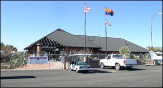 When the Grand
Canyon project finished in 1986, Bluff committed to a full-time service.
In 1987, he set up Red Rock Aviation as an FBO providing Exxon fuel and
aircraft services. In 1987, he was selling 30-40,000 gallons of aviation
fuel a year and by 1992 was selling 30-40,000 gallons each month. In 1991,
Private Pilot magazine named Red Rock Aviation as the second best FBO
in the nation because of its high quality service.
When the Grand
Canyon project finished in 1986, Bluff committed to a full-time service.
In 1987, he set up Red Rock Aviation as an FBO providing Exxon fuel and
aircraft services. In 1987, he was selling 30-40,000 gallons of aviation
fuel a year and by 1992 was selling 30-40,000 gallons each month. In 1991,
Private Pilot magazine named Red Rock Aviation as the second best FBO
in the nation because of its high quality service. 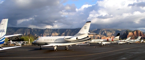 At the present
time on the Mesa, there are 11 different names of companies providing
flights, tours, charters, flight instruction and aviation services.
At the present
time on the Mesa, there are 11 different names of companies providing
flights, tours, charters, flight instruction and aviation services.