|
|
| Unalakleet Airport |
 |
| IATA: UNK – ICAO: PAUN – FAA LID: UNK |
| Summary |
| Airport type |
Public |
| Owner |
State of Alaska DOT&PF |
| Serves |
Unalakleet, Alaska |
| Elevation AMSL |
21 ft / 6 m |
| Coordinates |
63°53′18″N 160°47′56″W / 63.88833°N 160.79889°W / 63.88833; -160.79889 |
| Runways |
| Direction |
Length |
Surface |
| ft |
m |
| 14/32 |
6,004 |
1,830 |
Gravel |
| 8/26 |
2,000 |
610 |
Gravel |
| Source: Federal Aviation Administration |
Unalakleet Airport (IATA: UNK, ICAO: PAUN, FAA LID: UNK) is a state-owned public-use airport located one nautical mile (2 km) north of the central business district of Unalakleet, a city in the Nome Census Area of the U.S. state of Alaska. Facilities and aircraft
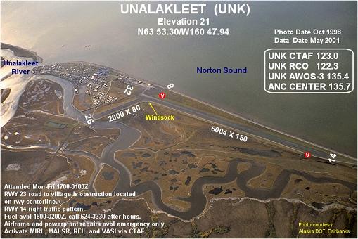
Unalakleet Airport covers an area of 5,837 acres (2,362 ha) at an elevation of 21 feet (6 m) above mean sea level. It has two gravel surfaced runways: 14/32 measuring 6,004 x 150 ft (1,830 x 46 m) and 8/26 measuring 2,000 x 80 ft (610 x 24 m).
Airlines and non-stop destinations
- Bering Air (Elim, Golovin, Koyuk, Nome, St. Michael, Shaktoolik, Stebbins, White Mountain)
The above content comes from Wikipedia and is published under free licenses – click here to read more.
Location
& QuickFacts
|
FAA
Information Effective: |
2006-06-08 |
|
Airport
Identifier: |
UNK |
|
Longitude/Latitude: |
160-47-56.2260W/63-53-18.0930N
-160.798952/63.888359 (Estimated) |
|
Elevation: |
21 ft / 6.40 m (Surveyed) |
|
Land: |
5837 acres |
|
From
nearest city: |
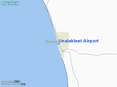
1 nautical miles N of Unalakleet, AK |
|
Location: |
Nome County, AK |
|
Magnetic
Variation: |
20E (1980) |
Owner
& Manager
|
Ownership: |
Publicly owned |
|
Owner: |
State Of Alaska Dot |
|
Address: |
2301 Peger Rd
Fairbanks, AK 99701 |
|
Phone
number: |
907-452-1911 |
|
Manager: |
Harry Johnson |
|
Address: |
Box 192
Unalakleet, AK 99684 |
|
Phone
number: |
907-624-3261 |
Airport
Operations and Facilities
|
Airport
Use: |
Open to public |
|
Wind
indicator: |
Yes |
|
Segmented
Circle: |
Yes |
|
Control
Tower: |
No |
|
Attendance
Schedule: |
ALL/MON-FRI/0800-1600 |
|
Lighting
Schedule: |
DUSK-DAWN
ACTVT MIRL RYS 08/26 & 14/32; VASI RYS 14 & 32;
MALSR RY 14; REIL RY 32 - CTAF. |
|
Beacon
Color: |
Clear-Green (lighted land airport) |
|
Landing
fee charge: |
No |
|
Sectional
chart: |
Mc Grath |
|
Region: |
AAL - Alaska |
|
Boundary
ARTCC: |
ZAN - Anchorage |
|
Tie-in
FSS: |
OME - Nome |
|
FSS
on Airport: |
No |
|
FSS
Phone: |
LC 443-2291 |
|
FSS
Toll Free: |
1-800-478-8400 |
|
Alternate
FSS: |
FAI - Fairbanks |
|
Alt.
FSS Toll Free: |
1-866-248-6516 |
|
NOTAMs
Facility: |
UNK (NOTAM-d service avaliable) |
|
Certification
type/date: |
?? ??/???? |
|
Federal
Agreements: |
N |
Airport
Communications
Airport
Services
|
Fuel
available: |
100LLA
FUEL AVBL 0900-1700; AFT HRS CALL 624-3330. |
|
Bottled
Oxygen: |
NONE |
|
Bulk
Oxygen: |
NONE |
|
Runway Information
Runway 08/26
|
Dimension: |
2000 x 80 ft / 609.6 x 24.4 m |
|
Surface: |
GRAVEL, Good Condition |
|
Edge
Lights: |
Medium |
|
|
Runway 08 |
Runway 26 |
|
Longitude: |
160-47-56.4910W |
160-47-12.3010W |
|
Latitude: |
63-53-00.4280N |
63-52-57.5490N |
|
Elevation: |
16.00 ft |
9.00 ft |
|
Alignment: |
98 |
127 |
|
Traffic
Pattern: |
Left |
Left |
|
Obstruction: |
8 ft fence, 249.0 ft from runway, 31:1 slope to
clear |
, 50:1 slope to clear |
|
Runway 14/32
|
Dimension: |
6004 x 150 ft / 1830.0 x 45.7 m |
|
Surface: |
GRAVEL, Good Condition |
|
Edge
Lights: |
Medium |
|
|
Runway 14 |
Runway 32 |
|
Longitude: |
160-48-21.8260W |
160-47-45.1820W |
|
Latitude: |
63-53-52.8820N |
63-52-56.0330N |
|
Elevation: |
21.00 ft |
16.00 ft |
|
Alignment: |
127 |
127 |
|
ILS
Type: |
LOC/DME |
|
|
Traffic
Pattern: |
Right |
Left |
|
Crossing
Height: |
39.00 ft |
48.00 ft |
|
VASI: |
4-box on left side |
4-box on left side |
|
Visual
Glide Angle: |
3.00� |
3.00� |
|
Approach
lights: |
MALSR |
|
|
Runway
End Identifier: |
|
Yes |
|
Radio Navigation
Aids
|
ID |
Type |
Name |
Ch |
Freq |
Var |
Dist |
|
JNR |
NDB |
North River |
|
382.00 |
20E |
1.2 nm |
|
UNK |
VOR/DME |
Unalakleet |
116X |
116.90 |
20E |
3.0 nm |
Remarks
- 299'
TWR 2.4 EAST.
- NO
SNOW REMOVAL OR DEICING BETWEEN 2100-0700.
- HEIGHT
RWY LGTS 30 INCHES.
- NWS
OBSERVATIONS 0545-1345 MON THROUGH FRI.
- RY
CONDITION NOT MONITORED; RECOMMEND VISUAL INSPECTION PRIOR TO LANDING.
- A
ROAD RUNS ALONG THE WEST SIDE OF RYS BUT IS CLOSED TO TRAFFIC.
- UNLIGHTED
TOWER (100 AGL) .4N AER 14.
- ESTABD
PRIOR TO 1959.
Based Aircraft
|
Aircraft
based on field: |
14 |
|
Single
Engine Airplanes: |
12 |
|
Multi
Engine Airplanes: |
2 |
Unalakleet Airport
Address: Nome County, AK
Tel:
907-452-1911, 907-624-3261
Images
and information placed above are from
http://www.airport-data.com/airport/UNK/
We
thank them for the data!
| General
Info |
| Country |
United
States |
| State |
ALASKA
|
| FAA ID |
UNK
|
| Latitude |
63-53-18.093N
|
| Longitude |
160-47-56.226W
|
| Elevation |
21 feet
|
| Near City |
UNALAKLEET
|
We don't guarantee the information is fresh and accurate. The data may
be wrong or outdated.
For more up-to-date information please refer to other sources.
|
|