 |
|
| Port Graham Airport |
 |
| IATA: PGM – ICAO: none – FAA LID: PGM |
| Summary |
| Airport type |
Public |
| Owner |
Alaska DOT&PF - Central Region |
| Serves |
Port Graham, Alaska |
| Elevation AMSL |
93 ft / 28 m |
| Coordinates |
59°20′54″N 151°49′54″W / 59.34833°N 151.83167°W / 59.34833; -151.83167 |
| Runways |
| Direction |
Length |
Surface |
| ft |
m |
| 12/30 |
1,975 |
602 |
Gravel/Dirt |
| Statistics |
| Enplanements (2008) |
2,916 |
| Aircraft operations (2005) |
950 |
| Source: Federal Aviation Administration |
Port Graham Airport (IATA: PGM, FAA LID: PGM) is a state-owned public-use airport located in Port Graham, in the Kenai Peninsula Borough of the U.S. state of Alaska.
This airport is included in the FAA's National Plan of Integrated Airport Systems for 2009–2013, where it is listed as commercial service - non-primary, an FAA category for airports with 2,500 to 10,000 passenger boardings (enplanements) per year. As per Federal Aviation Administration records, the airport had 2,916 enplanements in calendar year 2008, a decrease of 1.3% from the 2,953 enplanements in 2007.
Facilities and aircraft
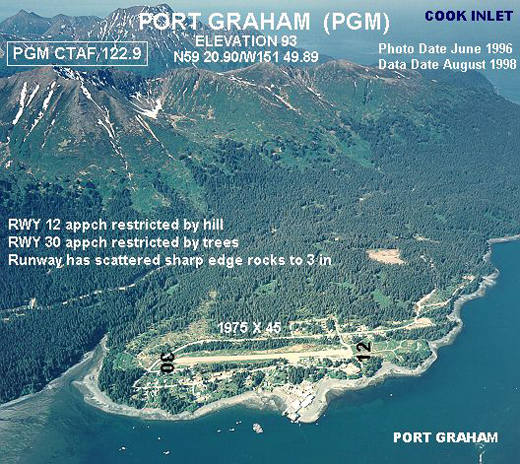
Port Graham Airport covers an area of 31 acres (13 ha) at an elevation of 93 feet (28 m) above mean sea level. It has one runway designated 12/30 with a gravel and dirt surface measuring 1,975 by 45 feet (602 x 14 m). For the 12-month period ending December 31, 2005, the airport had 950 aircraft operations, an average of 79 per month: 79% air taxi and 21% general aviation.
The above content comes from Wikipedia and is published under free licenses – click here to read more.
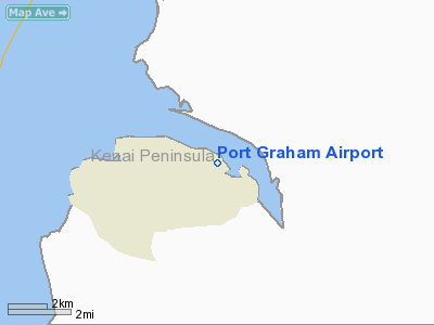
Location
& QuickFacts
|
FAA
Information Effective: |
2006-02-16 |
|
Airport
Identifier: |
PGM |
|
Longitude/Latitude: |
151-49-53.5400W/59-20-53.7340N
-151.831539/59.348259 (Estimated) |
|
Elevation: |
93 ft / 28.35 m (Estimated) |
|
Land: |
31 acres |
|
From
nearest city: |
0 nautical miles W of Port Graham, AK |
|
Location: |
Kenai-cook Inlet County, AK |
|
Magnetic Variation: |
23E (1985) |
Owner
& Manager
|
Ownership: |
Publicly owned |
|
Owner: |
St Of Ak Dotpf/c Rgn |
|
Address: |
Po Box 196900
Anchorage, AK 99519-6900 |
|
Phone number: |
907-266-0780 |
|
Manager: |
Kevin Jones |
|
Address: |
2336 Kachemak Dr
Homer, AK 99603 |
|
Phone number: |
907-235-8872
ALSO 907-235-5217. |
Airport
Operations and Facilities
|
Airport
Use: |
Open to public |
|
Wind
indicator: |
Yes |
|
Segmented
Circle: |
No |
|
Control
Tower: |
No |
|
Attendance
Schedule: |
UNATNDD |
|
Landing
fee charge: |
No |
|
Sectional
chart: |
Kodiak |
|
Region: |
AAL - Alaska |
|
Boundary
ARTCC: |
ZAN - Anchorage |
|
Tie-in
FSS: |
HOM - Homer |
|
FSS
on Airport: |
No |
|
FSS
Phone: |
907-235-8588 |
|
FSS
Toll Free: |
LC235-8588 |
|
Alternate
FSS: |
ENA - Kenai |
|
Alt.
FSS Toll Free: |
1-800-WX-BRIEF |
|
NOTAMs
Facility: |
SOV (NOTAM-d service avaliable) |
|
Federal Agreements: |
NS1 |
Airport
Communications
Airport
Services
|
Airframe
Repair: |
NONE |
|
Power
Plant Repair: |
NONE |
|
Bottled
Oxygen: |
NONE |
|
Bulk
Oxygen: |
NONE |
|
Runway Information
Runway 12/30
|
Dimension: |
1975 x 45 ft / 602.0 x 13.7 m |
|
Surface: |
GRVL-DIRT, Good Condition
SCATTERED SHARP EDGE ROCKS TO 3 INCHES ON RY. |
|
|
Runway 12 |
Runway 30 |
|
Traffic
Pattern: |
Left |
Left |
|
Obstruction: |
33 ft trees, 300.0 ft from runway, 100 ft left
of centerline, 9:1 slope to clear |
94 ft trees, 705.0 ft from runway, 7:1 slope
to clear |
|
Radio Navigation
Aids
|
ID |
Type |
Name |
Ch |
Freq |
Var |
Dist |
|
ACE |
NDB |
Kachemak |
|
277.00 |
24E |
20.3 nm |
|
HOM |
VOR/DME |
Homer |
093X |
114.60 |
24E |
24.5 nm |
Remarks
- RY
NOT REGULARLY ATNDD BY MAINT PSNL; RECOMMEND VISUAL INSPECTION PRIOR
TO USE.
- WATCH
FOR CHILDREN AND DOGS ON RWY.
- TREES
PENETRATE PART-77 TRANSITIONAL & APCH SURFACES.
- PILOTS
ARE REQUESTED TO SELF-ANNOUNCE ON CTAF PRIOR TO TAXIING ON RWY FOR DEPARTURE;
LEAVING THE RWY AND WITHIN 10 NM OF THE ARPT WHEN APPROACHING TO LAND.
Operational Statistics
|
Aircraft
Operations: |
19/Week |
|
Air Taxi: |
78.9% |
|
General
Aviation Itinerant: |
21.1% |
Port Graham Airport
Address:
Kenai-cook Inlet County, AK
Tel:
907-266-0780, 907-235-8872
Images
and information placed above are from
http://www.airport-data.com/airport/PGM/
We
thank them for the data!
| General
Info |
| Country |
United
States |
| State |
ALASKA
|
| FAA ID |
PGM
|
| Latitude |
59-20-53.734N
|
| Longitude |
151-49-53.540W
|
| Elevation |
93 feet
|
| Near City |
PORT GRAHAM
|
We don't guarantee the information is fresh and accurate. The data may
be wrong or outdated.
For more up-to-date information please refer to other sources.
|
|


