 |
|
Merle K (mudhole) Smith Airport |
| Merle K. (Mudhole) Smith Airport |
 |
| IATA: CDV – ICAO: PACV – FAA LID: CDV |
| Summary |
| Airport type |
Public |
| Owner |
State of Alaska DOT&PF - Northern Region |
| Serves |
Cordova, Alaska |
| Elevation AMSL |
54 ft / 16 m |
| Coordinates |
60°29′30″N 145°28′39″W / 60.49167°N 145.4775°W / 60.49167; -145.4775 |
| Runways |
| Direction |
Length |
Surface |
| ft |
m |
| 9/27 |
7,500 |
2,286 |
Asphalt |
| 16/34 |
1,899 |
579 |
Gravel |
| Statistics (2007) |
| Aircraft operations |
13,990 |
| Based aircraft |
29 |
| Source: Federal Aviation Administration |
Merle K. (Mudhole) Smith Airport (IATA: CDV, ICAO: PACV, FAA LID: CDV) is a state-owned public-use airport located 11 nautical miles (20 km) southeast of the central business district of Cordova, in the Valdez-Cordova Census Area of the U.S. state of Alaska. Airline service is subsidized by the Essential Air Service program. Facilities and aircraft
Merle K. (Mudhole) Smith Airport covers an area of 2,959 acres (1,197 ha) at an elevation of 54 feet (16 m) above mean sea level. It has two runways: 9/27 with a 7,500 x 150 ft (2,286 x 46 m) asphalt pavement and 16/34 with a 1,899 x 30 ft (579 x 9 m) gravel surface.
For the 12-month period ending August 2, 2007, the airport had 13,990 aircraft operations, an average of 38 per day: 46% general aviation, 29% air taxi, 18% scheduled commercial and 7% military. At that time there were 29 aircraft based at this airport: 93% single-engine and 7% helicopter.
Airlines and destinations
| Airlines |
Destinations |
| Alaska Airlines |
Anchorage, Yakutat |
| Arctic Circle Air |
Anchorage |
| Era Aviation |
Anchorage |
The above content comes from Wikipedia and is published under free licenses – click here to read more.
Location
& QuickFacts
|
FAA
Information Effective: |
2006-02-16 |
|
Airport
Identifier: |
CDV |
|
Longitude/Latitude: |
145-28-39.2000W/60-29-30.4000N
-145.477556/60.491778 (Estimated) |
|
Elevation: |
47 ft / 14.33 m (Surveyed) |
|
Land: |
2959 acres |
|
From
nearest city: |
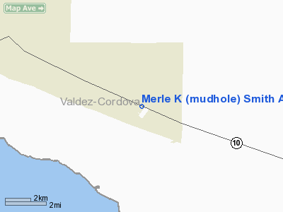
11 nautical miles SE of Cordova, AK |
|
Location: |
Cordova-mccarthy County, AK |
|
Magnetic Variation: |
22E (2005) |
Owner
& Manager
|
Ownership: |
Publicly owned |
|
Owner: |
Dot Nothern Region |
|
Address: |
2301 Peger Road
Fairbanks, AK 99709 |
|
Phone number: |
907-451-5250 |
|
Manager: |
Tom Justice |
|
Address: |
Box 598
Cordova, AK 99574 |
|
Phone number: |
907-424-3202 |
Airport
Operations and Facilities
|
Airport
Use: |
Open to public |
|
Wind
indicator: |
Yes |
|
Segmented
Circle: |
Yes |
|
Control
Tower: |
No |
|
Attendance
Schedule: |
ALL/MON-FRI/0700-1730,ALL/SAT-SUN/0700-1730 |
|
Lighting
Schedule: |
DUSK-DAWN
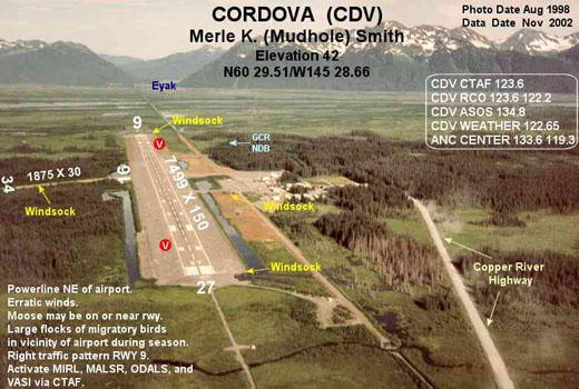
ACTVT MIRL RY 09/27 MALSR RY 27 ODALS RY 09 & VASI
RYS 09 & 27 - CTAF. |
|
Beacon
Color: |
Clear-Green (lighted land airport) |
|
Landing
fee charge: |
No |
|
Sectional
chart: |
Anchorage |
|
Region: |
AAL - Alaska |
|
Boundary
ARTCC: |
ZAN - Anchorage |
|
Tie-in
FSS: |
JNU - Juneau |
|
FSS
on Airport: |
No |
|
FSS
Phone: |
907-586-7380 |
|
FSS
Toll Free: |
1-800-WX-BRIEF |
|
NOTAMs
Facility: |
CDV (NOTAM-d service avaliable) |
|
Certification
type/date: |
I BS 5/1973
CLSD TO UNSKED ACR OPNS WITH MORE THAN 30 PSGR SEATS EXCP
PPR IN WRITING TO AMGR BOX 598 CORDOVA AK 99574. |
|
Federal Agreements: |
NGPSY |
Airport
Communications
Airport
Services
|
Airframe
Repair: |
NONE |
|
Power
Plant Repair: |
NONE |
|
Bottled
Oxygen: |
NONE |
|
Bulk
Oxygen: |
NONE |
|
Runway
Information
Runway 09/27
|
Dimension: |
7500 x 150 ft / 2286.0 x 45.7 m |
|
Surface: |
ASPH, Good Condition |
|
Surface
Treatment: |
Saw-cut or plastic Grooved |
|
Weight
Limit: |
Single wheel: 90000 lbs.
Dual wheel: 153000 lbs.
Dual
tandem wheel: 280000 lbs. |
|
Edge
Lights: |
Medium |
|
|
Runway 09 |
Runway 27 |
|
Longitude: |
145-29-48.2733W |
145-27-31.7470W |
|
Latitude: |
60-29-48.1412N |
60-29-17.8309N |
|
Elevation: |
36.00 ft |
37.00 ft |
|
Alignment: |
114 |
127 |
|
ILS
Type: |
|
ILS/DME |
|
Traffic
Pattern: |
Right |
Left |
|
Markings: |
Precision instrument, Good Condition |
Precision instrument, Good Condition |
|
Crossing
Height: |
41.00 ft |
58.00 ft |
|
VASI: |
4-box on left side |
4-box on left side |
|
Visual
Glide Angle: |
3.00� |
3.00� |
|
Approach
lights: |
ODALS |
MALSR |
|
Runway
End Identifier: |
No |
|
|
Obstruction: |
20 ft ant, 600.0 ft from runway, 250 ft
left of centerline, 20:1 slope to clear |
25 ft pole, 500.0 ft from runway, 450 ft
right of centerline, 12:1 slope to clear |
|
Runway 16/34
|
Dimension: |
1899 x 30 ft / 578.8 x 9.1 m |
|
Surface: |
GRVL, Fair Condition |
|
|
Runway 16 |
Runway 34 |
|
Longitude: |
145-28-35.6989W |
145-28-36.1437W |
|
Latitude: |
60-29-29.2888N |
60-29-10.5918N |
|
Elevation: |
45.00 ft |
34.00 ft |
|
Alignment: |
127 |
1 |
|
Traffic
Pattern: |
Left |
Left |
|
Obstruction: |
, 50:1 slope to clear |
140 ft trees, 2100.0 ft from runway, 150
ft left of centerline, 15:1 slope to clear |
|
Radio
Navigation Aids
|
ID |
Type |
Name |
Ch |
Freq |
Var |
Dist |
|
GCR |
NDB |
Glacier River |
|
404.00 |
22E |
0.4 nm |
|
HBK |
NDB |
Hinchinbrook |
|
362.00 |
27E |
19.1 nm |
|
ALJ |
NDB |
Orca Bay |
|
233.00 |
23E |
32.9 nm |
|
MNL |
NDB |
Mineral Creek |
|
524.00 |
27E |
45.9 nm |
|
JOH |
VOR/DME |
Johnstone Point |
114X |
116.70 |
27E |
33.2 nm |
Remarks
-
ERRATIC WINDS.
-
SNOW
REMOVAL ICE REMOVAL & ARPT HAZ RPRTNG ONLY PERFORMED DURG DUTY
HRS UNLESS BY PRIOR ARNGMT IN WRITING WITH MANAGEMENT.
-
NO
SNOW REMOVAL OR DEICING PERFORMED BTN 1600 & 0700 DAILY; RWY
COND REPORTS WILL REFLECT DAY OPNS ONLY.
-
MOOSE
OCNLY ON OR NEAR RWYS; LARGE FLOCKS OF MIGRATORY BIRDS IN VCNTY
DURG SEASON.
-
ARFF
EQUIP STAFFED DURG PERIODS OF ACR ACTVTY ONLY.
-
CORDOVA
WX REPORT AVBL LC 424-7614 OR 122.65.
-
RY
16/34 THR AND SIDE MARKINGS REMOVED IN WINTER.
-
TWY
DELTA LIMITED TO 12,500 LBS.
-
JOHNSTONE
POINT WX CAMERA AVBL ON INTERNET AT HTTP://AKWEATHERCAMS.FAA.GOV
Based
Aircraft
|
Aircraft
based on field: |
29 |
|
Single
Engine Airplanes: |
27 |
|
Helicopters: |
2 |
Major
Carriers Serving This Airport
Most
Popular Destinations
|
Ted Stevens Anchorage Intl (ANC) |
50.0% |
|
Yakutat (YAK) |
50.0% |
Most
Popular Aircraft
|
N778AS |
4.9% |
|
N763AS |
4.3% |
|
N703AS |
4.3% |
|
N709AS |
4.3% |
|
N706AS |
3.3% |
|
N793AS |
3.3% |
|
N795AS |
3.3% |
|
N788AS |
2.7% |
|
N774AS |
2.7% |
|
N776AS |
2.7% |
Operational
Statistics
|
Aircraft
Operations: |
46/Day |
|
Air
Carrier: |
15.1% |
|
Air
Taxi: |
24.3% |
|
General
Aviation Local: |
27.3% |
|
General
Aviation Itinerant: |
12.1% |
|
Military: |
6.1% |
Merle K (mudhole) Smith
Airport
Address:
Cordova-mccarthy County, AK
Tel:
907-451-5250, 907-424-3202
Images
and information placed above are from
http://www.airport-data.com/airport/CDV/
We
thank them for the data!
| General
Info |
| Country |
United
States |
| State |
ALASKA
|
| FAA
ID |
CDV
|
| Latitude |
60-29-30.602N
|
| Longitude |
145-28-39.541W
|
| Elevation |
42 feet
|
| Near
City |
CORDOVA
|
We don't guarantee the information is fresh and accurate. The data may
be wrong or outdated.
For more up-to-date information please refer to other sources.
|
|


