|
 |
|
||||
|
Cold Bay Airport (IATA: CDB, ICAO: PACD, FAA LID: CDB) is a public-use airport located in Cold Bay, a city in the Aleutians East Borough of the U.S. state of Alaska. It is owned by the state and is one of the main airports serving the Alaska Peninsula. Cold Bay's main runway is the fifth-largest in Alaska and was built during World War II. Today, it is used by scheduled cargo flights (Alaska Central Express and Evergreen International Airlines), and is sometimes used as an emergency diversion airport for passenger flights across the Pacific Ocean. CDB is also an alternate landing site for NASA Space Shuttles. There is also a National Weather Service office (which sends up radiosonde balloons twice a day) colocated with the FAA Flight Service Station. The NWS ranks Cold Bay as the cloudiest city in the United States. Air taxi operators fly in and out of the airport daily. Airline and destinations
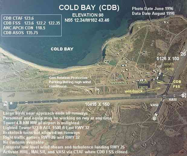
Facilities and aircraftCold Bay Airport has two asphalt paved runways: 14/32 is 10,415 by 150 feet (3,174 x 46 m) and 8/26 is 4,235 by 150 feet (1,291 x 46 m). For the 12-month period ending July 13, 2007, the airport had 3,794 aircraft operations, an average of 10 per day: 53% air taxi, 35% general aviation, 9% scheduled commercial and 4% military. HistoryThe airport was constructed during World War II as Fort Randall Army Airfield during the military buildup of Alaska in secret beginning in 1941. Disguised as civilian employees of the Blair Canning and Packing Company, Army personnel in civilian clothes were shipped to Cold Bay. Although construction began in December 1941, the airfield was ready for operation by March 1942. Because of the foresight of Alaska's military commanders, the new airfield, along with another new secret airfield Cape Field at Umnak, was ready to contribute during the Battle of Dutch Harbor in June 1942. The airfield at Cold Bay would continue to contribute throughout the war. Known units assigned to Fort Randal AAF were:
Fort Randall AAF was also used by the United States Navy during the Aleutian campaign. A two-gun 6-inch naval gun battery was located at Grant Point. One gun is on display near the town dump. A four-gun 155mm gun battery on Panama mounts was located at Mortensen's Lagoon at Thin Point. The HECP bunker still exists at Pride Lake. After the war, the airfield was named Thornbrough Air Force Base in 1948 for Captain George W. Thornbrough, a U.S. Army Air Corps B-26 pilot. Captain Thornbrough fought during the Battle of Dutch Harbor in June 1942, bravely attacking a Japanese aircraft carrier that was launching strike aircraft at Dutch Harbor. Although his torpedo struck the carrier, it failed to explode. Captain Thornbrough returned to his airfield to refuel and rearm and then took off to rejoin the fight. The aircraft and entire crew were lost during their return from this mission, when they were unable to land back at Cold Bay. The wreckage of Captain Thornbrough's aircraft was found fifty miles from Cold Bay on the north side of the Alaskan Peninsula the following month. It was redesignated from Army Air Base (AAB) to an Air Force Base (AFB) on 28 March 1948 along with seven other Army Air Bases in Alaska. It's chief assets were a 10,000 ft. runway and a deep water dock. Both the runway and dock have continued in service to this day serving as transportation hubs for airlines and shipping. Thornbrough Air Force Base was active from 1946 until 1953. IncidentsOn September 8, 1973 World Airways Flight 802 a Military Airlift Command cargo flight crashed into Mount Dutton when on approach to Cold Bay. All six people on board were killed. The above content comes from Wikipedia and is published under free licenses – click here to read more.
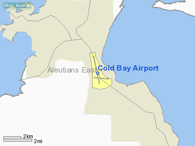
Cold Bay is one of the main commercial centers of the Alaska Peninsula, and is home to Cold Bay Airport. Cold Bay is located at 55°12'33" North, 162°42'51" West (55.209038, -162.714298)GR1. According to the U.S. Census Bureau, the city has a total area of 183.7 km² (70.9 mi²). 140.8 km² (54.4 mi²) of it is land and 42.9 km² (16.6 mi²) of it is water. The total area is 23.34% water. Cold Bay Airport (IATA: CDB, ICAO: PACD) is an airport in Cold Bay, Alaska. It is one of the main airports serving the Alaska Peninsula. Cold Bay's main runway is the fifth-largest in Alaska and was built during World War II. Today, it is used by scheduled cargo flights (Alaska Central Express and Evergreen International Airlines), and is sometimes used as an emergency diversion airport for passenger flights across the Pacific Ocean. Six aircraft are based permanently at the airport. Although there is no scheduled passenger service, air taxi operators fly in and out of the airport daily. Location & QuickFacts
Owner & Manager
Airport Operations and Facilities
Airport Communications
Airport Services
Runway InformationRunway 08/26
Runway 14/32
Radio Navigation Aids
Remarks
Based Aircraft
Operational Statistics
Cold Bay Airport Address: Aleutian Islands County, AK Tel: 907-269-0747 Images
and information placed above are from We thank them for the data!
We don't guarantee the information is fresh and accurate. The data may be wrong or outdated. For more up-to-date information please refer to other sources. |
||||||||||||||||||||||||||||||||||||||||||||||||||||||||||||||||||||||||||||||||||||||||||||||||||||||||||||||||||||||||||||||||||||||||||||||||||||||||||||||||||||||||||||||||||||||||||||||||||||||||||||||||||||||||||||||||||||||||||||||||||||||||||||||||||||||||||||||||||||||||||||||||||||||||||||||||||||||||||||||||||||

 |
|
Copyright 2004-2026 © by Airports-Worldwide.com, Vyshenskoho st. 36, Lviv 79010, Ukraine Legal Disclaimer |