|
|
| Anaktuvuk Pass Airport |
 |
| IATA: AKP – ICAO: PAKP – FAA LID: AKP |
| Summary |
| Airport type |
Public |
| Owner |
North Slope Borough |
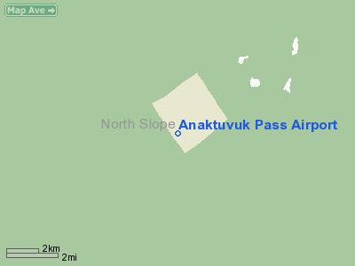
| Location |
Anaktuvuk Pass, Alaska |
| Elevation AMSL |
2,103 ft / 641 m |
| Coordinates |
68°08′01″N 151°44′36″W / 68.13361°N 151.74333°W / 68.13361; -151.74333 |
| Runways |
| Direction |
Length |
Surface |
| ft |
m |
| 1/19 |
4,800 |
1,463 |
Gravel |
| Statistics |
| Enplanements (2007) |
3,749 |
| Aircraft operations (2005) |
3,600 |
| Source: Federal Aviation Administration |
Anaktuvuk Pass Airport (IATA: AKP, ICAO: PAKP, FAA LID: AKP) is a public-use airport located in Anaktuvuk Pass, a city in the North Slope Borough of the U.S. state of Alaska. The airport is owned by North Slope Borough.
As per Federal Aviation Administration records, this airport had 3,749 passenger boardings (enplanements) in calendar year 2007, an increase of 9% from the 3,444 enplanements in 2006. Facilities and aircraft
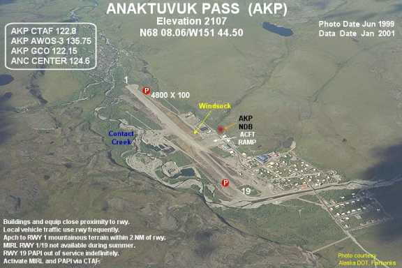
Anaktuvuk Pass Airport has one runway designated 1/19 with a 4,800 x 100 ft (1,463 x 30 m) gravel surface. For 12-month period ending December 31, 2005, the airport had 3,600 aircraft operations, an average of 300 per month: 89% air taxi and 11% general aviation.
Airlines and non-stop destinations
- Arctic Circle Air (Fairbanks)
- Everts Air (Allakaket)
- Warbelow's Air Ventures (Allakaket, Bettles, Fairbanks)
- Wright Air Service (Bettles, Fairbanks)
The above content comes from Wikipedia and is published under free licenses – click here to read more.
Location & QuickFacts
|
FAA
Information Effective: |
2005-10-27 |
|
Airport Identifier: |
AKP |
|
Longitude/Latitude: |
151-44-36.0300W/68-08-00.9500N
-151.743342/68.133597 (Estimated) |
|
Elevation: |
2103 ft / 640.99
m (Surveyed) |
|
Land: |
0
acres |
|
From nearest city: |
0 nautical miles
SE of Anaktuvuk Pass, AK |
|
Location: |
Yukon-koyukuk
County, AK |
|
Magnetic Variation: |
27E (1985) |
Owner & Manager
|
Ownership: |
Publicly
owned |
|
Owner: |
North Slope Borough |
|
Address: |
Box
69
Barrow, AK 99723 |
|
Phone number: |
907-852-2611 |
|
Manager: |
Eddie
Bodfish |
|
Address: |
Box 69
Barrow, AK 99723 |
|
Phone number: |
907-852-2611
X 342 |
Airport Operations and Facilities
|
Airport
Use: |
Open
to public |
|
Wind indicator: |
Yes |
|
Segmented Circle: |
Yes |
|
Control Tower: |
No |
|
Attendance Schedule: |
ALL/ALL/ALL |
|
Lighting Schedule: |
RDO-CTL
ACTVT MIRL RY 01/19 - 122.8. |
|
Landing fee charge: |
No |
|
Sectional chart: |
Point
Barrow |
|
Region: |
AAL - Alaska |
|
Boundary ARTCC: |
ZAN
- Anchorage |
|
Tie-in FSS: |
FAI - Fairbanks |
|
FSS on Airport: |
No |
|
FSS Phone: |
907-474-0788 |
|
FSS Toll Free: |
1-866-248-6516 |
|
NOTAMs Facility: |
AKP (NOTAM-d service
avaliable) |
|
Federal Agreements: |
NGY |
Airport Communications
Airport Services
|
Fuel
available: |
B |
|
Airframe
Repair: |
NONE |
|
Power
Plant Repair: |
NONE |
|
Bottled Oxygen: |
NONE |
|
Bulk Oxygen: |
NONE |
Runway Information
Runway 01/19
|
Dimension: |
4800
x 100 ft / 1463.0 x 30.5 m |
|
Surface: |
GRAVEL, Good Condition |
|
Edge Lights: |
Medium |
|
|
Runway 01 |
Runway 19 |
|
Longitude: |
151-45-15.3300W |
151-43-56.7200W |
|
Latitude: |
68-07-42.4400N |
68-08-19.4700N |
|
Elevation: |
2048.00 ft |
2102.00 ft |
|
Alignment: |
38 |
127 |
|
Traffic Pattern: |
Left |
Left |
|
Crossing Height: |
41.00 ft |
40.00 ft |
|
VASI: |
2-light PAPI on left side
PAPI OTS INDEFLY. |
2-light PAPI on left side
PAPI ALIGNED 20 DEG W OF EXTNDD CNTRLN. ON APCH TO RY 01 MOUNTAINOUS
TERRAIN LCTD WITHIN 2 NM OF THE RY. |
|
Visual Glide Angle: |
3.00� |
3.00� |
|
Obstruction: |
12 ft brush, 300.0 ft from runway, 100 ft left of centerline,
25:1 slope to clear |
145 ft hill, 5000.0 ft from runway, 34:1 slope to clear |
|
Radio Navigation Aids
|
ID |
Type |
Name |
Ch |
Freq |
Var |
Dist |
|
AKP |
NDB |
Anaktuvuk Pass |
|
348.00 |
27E |
0.2
nm |
Remarks
-
RY 01/19 RECOMMEND VISUAL
INSPECTION PRIOR TO USE.
-
MIRL RY 01/19 NOT AVBL
DURING SUMMER.
-
BLDGS & EQUIPMENT
IN CLOSE PROXIMITY TO RY; LOCAL VEH TRAFFIC USE RY FREQUENTLY.
-
BRUSH TO 10' WITHIN 90'
EACH SIDE OR RY CENTERLINE.
-
NSTD GCO 122.15 4 CLICKS
FOR DEADHORSE FSS. GCO UNAVBL WHEN DEADHORSE FSS CLSD.
Operational Statistics
|
Aircraft
Operations: |
70/Week |
|
Air Taxi: |
88.9% |
|
General Aviation
Itinerant: |
11.1% |
Anaktuvuk Pass Airport
Address:Yukon-koyukuk
County, AK
Tel:
907-852-2611
Images
and information placed above are from
http://www.airport-data.com/airport/AKP/
We thank them for the
data!
| General
Info |
| Country |
United
States |
| State |
ALASKA
|
| FAA ID |
AKP
|
| Latitude |
68-08-00.950N
|
| Longitude |
151-44-36.030W
|
| Elevation |
2103 feet
|
| Near City |
ANAKTUVUK
PASS |
We don't guarantee the information is fresh and accurate. The data may be wrong or outdated.
For more up-to-date information please refer to other sources.
|
|