 |
|
| Ambler Airport |
 |
| IATA: ABL – ICAO: PAFM – FAA LID: AFM |
| Summary |
| Airport type |
Public |
| Owner |
Alaska DOT&PF - Northern Region |
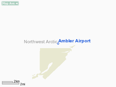
| Serves |
Ambler, Alaska |
| Elevation AMSL |
334 ft / 102 m |
| Coordinates |
67°06′23″N 157°51′27″W / 67.10639°N 157.8575°W / 67.10639; -157.8575 |
| Runways |
| Direction |
Length |
Surface |
| ft |
m |
| 9/27 |
2,400 |
732 |
Gravel |
| 18/36 |
3,000 |
914 |
Gravel |
| Statistics (2008) |
| Enplanements |
2,357 |
| Source: Federal Aviation Administration |
Ambler Airport (IATA: ABL, ICAO: PAFM, FAA LID: AFM) is a state-owned public-use airport located one nautical mile (1.85 km) north of the central business district of Ambler, a city in the Northwest Arctic Borough of the U.S. state of Alaska.
As per Federal Aviation Administration records, the airport had 2,357 passenger boardings (enplanements) in calendar year 2008, an increase of 0.13% from the 2,354 enplanements in 2007. This airport is included in the FAA's National Plan of Integrated Airport Systems for 2009–2013, which categorizes it as a general aviation facility.
Although most U.S. airports use the same three-letter location identifier for the FAA and IATA, this airport is assigned AFM by the FAA and ABL by the IATA. The airport's ICAO identifier is PAFM. Facilities
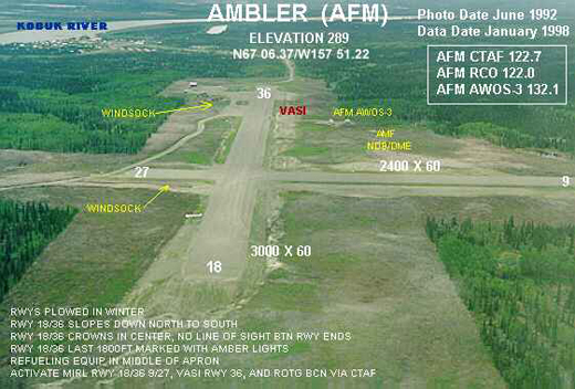
Ambler Airport covers an area of 272 acres (110 ha) at an elevation of 334 feet (102 m) above mean sea level. It has two runways with gravel surfaces: 9/27 measures 2,400 by 60 feet (732 x 18 m) and 18/36 is 3,000 by 60 feet (914 x 18 m).
Airline and destinations
- Bering Air (Shungnak [non stop], Kobuk [1 stop], Kotzebue [2 stops])
- Hageland Aviation Services
The above content comes from Wikipedia and is published under free licenses – click here to read more.
Location & QuickFacts
|
FAA
Information Effective: |
2005-10-27 |
|
Airport Identifier: |
AFM |
|
Longitude/Latitude: |
157-51-26.9000W/67-06-22.7300N
-157.857472/67.106314 (Estimated) |
|
Elevation: |
334 ft / 101.80 m
(Estimated) |
|
Land: |
272
acres |
|
From nearest city: |
1 nautical miles
N of Ambler, AK |
|
Location: |
Northwest
Arctic County, AK |
|
Magnetic Variation: |
23E (1985) |
Owner & Manager
|
Ownership: |
Publicly
owned |
|
Owner: |
State Of Ak Dotpf/n
Rgn |
|
Address: |
2301
Peger Road
Fairbanks, AK 99709 |
|
Phone number: |
907-451-5250 |
|
Manager: |
Kenny
Gallahorn |
|
Address: |
Box 55
Kotzebue, AK 99752 |
|
Phone number: |
907-442-3147 |
Airport Operations and Facilities
|
Airport
Use: |
Open
to public |
|
Wind indicator: |
Yes |
|
Segmented Circle: |
Yes |
|
Control Tower: |
No |
|
Attendance Schedule: |
UNATNDD |
|
Lighting Schedule: |
DUSK-DAWN
ACTVT VASI RY 36 & MIRL RYS 18/36 & 09/27; ROTG BCN &
WINDSOCK LIGHTS - CTAF. |
|
Beacon Color: |
Clear-Green (lighted
land airport) |
|
Landing fee charge: |
No |
|
Sectional chart: |
Fairbanks |
|
Region: |
AAL
- Alaska |
|
Boundary ARTCC: |
ZAN - Anchorage |
|
Tie-in FSS: |
OTZ
- Kotzebue |
|
FSS on Airport: |
No |
|
FSS Phone: |
907-442-3310 |
|
FSS Toll Free: |
1-478-7460 |
|
Alternate FSS: |
FAI
- Fairbanks |
|
Alt. FSS Toll Free: |
1-866-248-6516 |
|
NOTAMs Facility: |
AFM
(NOTAM-d service avaliable) |
|
Federal Agreements: |
NGY |
Airport Communications
Airport Services
|
Airframe
Repair: |
NONE |
|
Power
Plant Repair: |
NONE |
|
Bottled Oxygen: |
NONE |
|
Bulk Oxygen: |
NONE |
Runway Information
Runway 09/27
|
Dimension: |
2400
x 60 ft / 731.5 x 18.3 m |
|
Surface: |
GRVL,
Good Condition |
|
Edge Lights: |
Medium
LAST 1800 FT RY 36 MARKED WITH AMBER LGTS. |
|
|
Runway 09 |
Runway 27 |
|
Longitude: |
157-52-04.8700W |
157-51-08.8100W |
|
Latitude: |
67-06-33.6200N |
67-06-24.6100N |
|
Elevation: |
334.00 ft |
310.00 ft |
|
Alignment: |
112 |
127 |
|
Traffic Pattern: |
Left |
Left |
|
Obstruction: |
50 ft trees, 1200.0 ft from runway, 24:1 slope to clear |
,
50:1 slope to clear |
|
Runway 18/36
|
Dimension: |
3000
x 60 ft / 914.4 x 18.3 m |
|
Surface: |
GRVL,
Good Condition |
|
Edge Lights: |
Medium
LAST 1800 FT RY 36 MARKED WITH AMBER LGTS. |
|
|
Runway 18 |
Runway 36 |
|
Longitude: |
157-51-04.4900W |
157-51-33.4100W |
|
Latitude: |
67-06-31.2700N |
67-06-03.9800N |
|
Elevation: |
310.00 ft |
292.00 ft |
|
Alignment: |
127 |
22 |
|
Traffic Pattern: |
Left |
Left |
|
Crossing Height: |
0.00 ft |
25.00 ft |
|
VASI: |
|
4-box on left side |
|
Visual Glide Angle: |
0.00� |
3.00� |
|
Radio Navigation Aids
|
ID |
Type |
Name |
Ch |
Freq |
Var |
Dist |
Remarks
-
RY 18/26 SLOPES DOWN
N TO S. RY 18 THR 52 FT HIGHER.
-
CARIBOU INVOF RY.
-
ACTVT AWOS - 125.5.
-
RY CONDITIONS NOT MONITORED;
RECOMMEND VISUAL INSPECTION PRIOR TO LANDING.
Based Aircraft
|
Aircraft
based on field: |
2 |
|
Single Engine Airplanes: |
2 |
Operational Statistics
|
Aircraft
Operations: |
97/Week |
|
Air Taxi: |
80.0% |
|
General Aviation
Itinerant: |
20.0% |
Ambler Airport
Address: Northwest
Arctic County, AK
Tel:
907-451-5250.
907-442-3147
Images
and information placed above are from
http://www.airport-data.com/airport/AFM/
We thank them for the data!
| General
Info |
| Country |
United
States |
| State |
ALASKA
|
| FAA ID |
AFM
|
| Latitude |
67-06-21.977N
|
| Longitude |
157-51-13.033W
|
| Elevation |
289 feet
|
| Near City |
AMBLER
|
We don't guarantee the information is fresh and accurate. The data may be wrong or outdated.
For more up-to-date information please refer to other sources.
|
|


