|
|
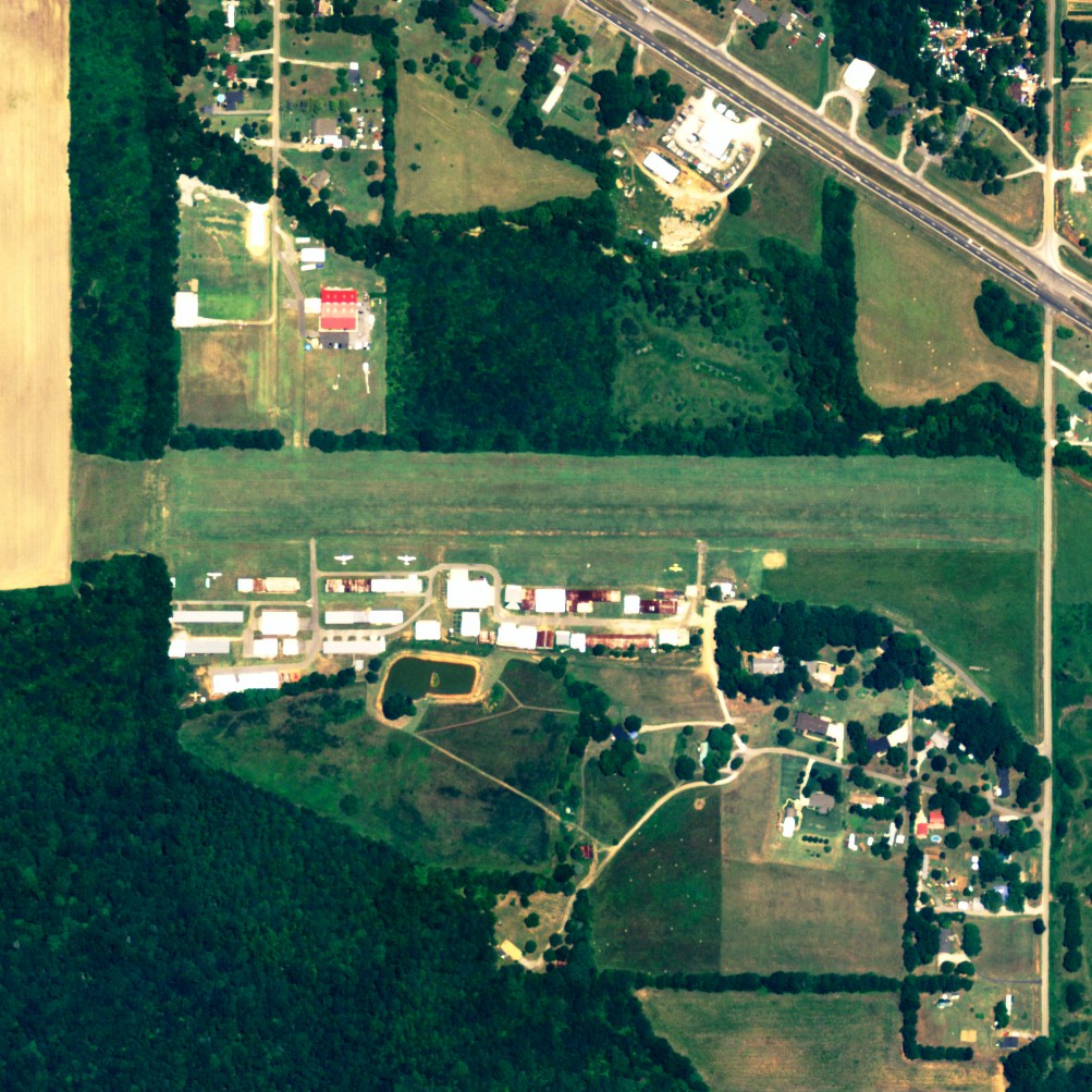
| Moontown Airport |
 |
| NAIP aerial image, 15 June 2006 |
| IATA: none – ICAO: none – FAA LID: 3M5 |
| Summary |
| Airport type |
Public |
| Owner/Operator |
George Myers |
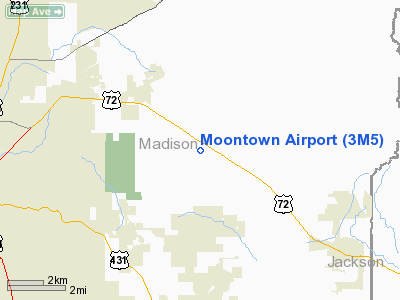
| Location |
Huntsville, Alabama |
| Elevation AMSL |
650 ft / 198 m |
| Coordinates |
34°44′50″N 086°27′41″W / 34.74722°N 86.46139°W / 34.74722; -86.46139 |
| Website |
MoontownAirport.com |
| Runways |
| Direction |
Length |
Surface |
| ft |
m |
| 9/27 |
2,180 |
664 |
Turf |
| Statistics (2009) |
| Aircraft operations |
15,784 |
| Based aircraft |
96 |
| Source: Federal Aviation Administration |
Moontown Airport (FAA LID: 3M5) is a privately-owned public-use airport located seven nautical miles (13 km) east of the central business district of Huntsville, a city in Madison County, Alabama, United States. It is 16 miles (26 km) miles east of Huntsville International Airport (HSV).
Facilities and aircraft
Moontown Airport covers an area of 17 acres (7 ha) at an elevation of 650 feet (198 m) above mean sea level. It has one runway designated 9/27 with a turf surface measuring 2,180 by 160 feet (664 x 49 m).
For the 12-month period ending April 22, 2009, the airport had 15,784 general aviation aircraft operations, an average of 43 per day. At that time there were 96 aircraft based at this airport: 86% single-engine, 2% multi-engine, 10% glider and 1% ultralight.
The above content comes from Wikipedia and is published under free licenses – click here to read more.
Location
& QuickFacts
|
FAA Information Effective: |
2007-01-18 |
|
Airport
Identifier: |
3M5 |
|
Airport
Status: |
Operational |
|
Longitude/Latitude: |
086-27-40.9590W/34-44-50.3250N
-86.461377/34.747312 (Estimated) |
|
Elevation: |
650 ft / 198.12 m (Estimated) |
|
Land: |
17
acres |
|
From
nearest city: |
7 nautical miles E of Huntsville, AL |
|
Location: |
Madison County, AL |
|
Magnetic Variation: |
01W (1985) |
Owner
& Manager
|
Ownership: |
Privately owned |
|
Owner: |
George Myers |
|
Address: |
200 Airport Dr
Brownsboro, AL 35741 |
|
Phone
number: |
256-852-9781 |
|
Manager: |
George Myers |
|
Address: |
200 Airport Drive
Brownsboro, AL 35741 |
|
Phone number: |
256-852-9781 |
Airport
Operations and Facilities
|
Airport Use: |
Open to public |
|
Wind
indicator: |
Yes |
|
Segmented
Circle: |
No |
|
Control
Tower: |
No |
|
Lighting
Schedule: |
RDO-CTL
ACTVT ROTG BCN - CTAF. |
|
Beacon
Color: |
Clear-Green (lighted land airport)
BCN SHIELDED ON SOUTH. |
|
Landing
fee charge: |
No |
|
Sectional
chart: |
Atlanta |
|
Region: |
ASO - Southern |
|
Boundary
ARTCC: |
ZME - Memphis |
|
Tie-in
FSS: |
ANB - Anniston |
|
FSS
on Airport: |
No |
|
FSS
Toll Free: |
1-800-WX-BRIEF |
|
NOTAMs
Facility: |
ANB (NOTAM-d service avaliable) |
Airport
Communications
|
CTAF: |
122.700 |
|
Unicom: |
122.700 |
Airport
Services
|
Fuel available: |
100LLMOGAS |
|
Airframe Repair: |
MINOR |
|
Power Plant Repair: |
MINOR |
|
Bottled
Oxygen: |
NONE |
|
Bulk
Oxygen: |
NONE |
|
Runway Information
Runway 09/27
|
Dimension: |
2180 x 160 ft / 664.5 x 48.8 m |
|
Surface: |
TURF, Good Condition |
|
Edge
Lights: |
Low |
|
|
Runway 09 |
Runway 27 |
|
Traffic
Pattern: |
Left |
Right |
|
Obstruction: |
60 ft trees, 1700.0 ft from runway, 28:1 slope
to clear |
45 ft tree, 570.0 ft from runway, 80 ft left
of centerline, 12:1 slope to clear |
|
Radio Navigation
Aids
|
ID |
Type |
Name |
Ch |
Freq |
Var |
Dist |
|
SYI |
FAN MARKER |
Bomar |
|
|
01W |
44.3 nm |
|
HUA |
NDB |
Redstone |
|
287.00 |
00W |
11.6 nm |
|
CWH |
NDB |
Capshaw |
|
350.00 |
01W |
15.8 nm |
|
TNY |
NDB |
Kelso |
|
358.00 |
01W |
23.6 nm |
|
CPP |
NDB |
Cole Spring |
|
230.00 |
01W |
29.0 nm |
|
ARF |
NDB |
Saratoga |
|
296.00 |
02W |
32.0 nm |
|
BGF |
NDB |
Boiling Fork |
|
263.00 |
02W |
32.3 nm |
|
GZS |
NDB |
Giles/dcmsnd |
|
375.00 |
00E |
38.1 nm |
|
UOS |
NDB |
Sewanee |
|
275.00 |
02E |
39.1 nm |
|
FTP |
NDB |
Fort Payne |
|
426.00 |
01W |
41.3 nm |
|
ULH |
NDB |
Burwi |
|
332.00 |
03W |
44.3 nm |
|
APT |
NDB |
Jasper |
|
382.00 |
02W |
47.2 nm |
|
LUG |
NDB |
Verona |
|
251.00 |
00W |
48.4 nm |
|
LRT |
NDB |
Lawrenceburg |
|
269.00 |
00E |
49.1 nm |
|
UXM |
VOR |
Tullahoma Regional |
|
109.65 |
03W |
39.5 nm |
|
DCU |
VOR/DME |
Decatur |
075X |
112.80 |
01W |
24.4 nm |
|
SYI |
VOR/DME |
Shelbyville |
027X |
109.00 |
01W |
49.0 nm |
|
GAD |
VOR/DME |
Gadsden |
070X |
112.30 |
02E |
50.0 nm |
|
RQZ |
VORTAC |
Rocket |
059X |
112.20 |
02E |
9.0 nm |
|
HSV |
VOT |
Huntsville |
|
111.00 |
|
20.8 nm |
Based
Aircraft
|
Aircraft
based on field: |
92 |
|
Single
Engine Airplanes: |
81 |
|
Gliders: |
10 |
|
Ultralights: |
1 |
Operational Statistics
Time Period: 1998-10-02
- 1999-10-01
|
Aircraft
Operations: |
44/Day |
|
General
Aviation Local: |
36.6% |
|
General
Aviation Itinerant: |
63.4% |
Moontown Airport
Address:
Madison County, AL
Tel:
256-852-9781
Images
and information placed above are from
http://www.airport-data.com/airport/3M5/
We
thank them for the data!
| General
Info |
| Country |
United
States |
| State |
ALABAMA
|
| FAA ID |
3M5
|
| Latitude |
34-44-50.325N
|
| Longitude |
086-27-40.959W
|
| Elevation |
650 feet
|
| Near City |
HUNTSVILLE
|
We don't guarantee the information is fresh and accurate. The data may
be wrong or outdated.
For more up-to-date information please refer to other sources.
|
|