 |
|
|
|
|
|
Location
& QuickFacts
|
FAA Information Effective: |
2007-01-18 |
|
Airport
Identifier: |
25A |
|
Airport
Status: |
Operational |
|
Longitude/Latitude: |
085-49-31.8760W/33-44-23.3640N
-85.825521/33.739823 (Estimated) |
|
Elevation: |
680 ft / 207.26 m (Estimated) |
|
Land: |
20
acres |
|
From
nearest city: |
1 nautical miles SW of Weaver, AL |
|
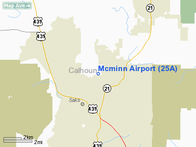
Location: |
Calhoun County, AL |
|
Magnetic Variation: |
01W (1985) |
Owner
& Manager
|
Ownership: |
Privately owned |
|
Owner: |
Pat Mc Minn |
|
Address: |
75 Mc Minn Rd.
Anniston, AL 36201 |
|
Phone
number: |
205-820-1954 |
|
Manager: |
Pat Mc Minn
CAROL MC MINN (ASST MANAGER) 205-820-1954. |
|
Address: |
75 Mc Minn Rd.
Anniston, AL 36201 |
|
Phone number: |
205-820-9750 |
Airport
Operations and Facilities
|
Airport Use: |
Open to public |
|
Wind
indicator: |
Yes |
|
Segmented
Circle: |
No |
|
Control
Tower: |
No |
|
Landing
fee charge: |
No |
|
Sectional
chart: |
Atlanta |
|
Region: |
ASO - Southern |
|
Boundary
ARTCC: |
ZTL - Atlanta |
|
Tie-in
FSS: |
ANB - Anniston |
|
FSS
on Airport: |
No |
|
FSS
Toll Free: |
1-800-WX-BRIEF |
|
NOTAMs
Facility: |
ANB (NOTAM-d service avaliable) |
Airport
Communications
|
CTAF: |
122.800 |
|
Unicom: |
122.800
UNICOM NOT ATTENDED REGULARLY. |
Airport
Services
|
Fuel available: |
100LLMOGAS |
|
Airframe Repair: |
MAJOR |
|
Power Plant Repair: |
MAJOR |
|
Bottled
Oxygen: |
NONE |
|
Bulk
Oxygen: |
NONE |
|
Runway Information
Runway 08/26
|
Dimension: |
2650 x 30 ft / 807.7 x 9.1 m |
|
Surface: |
ASPH, Fair Condition |
|
|
Runway 08 |
Runway 26 |
|
Traffic
Pattern: |
Right |
Left |
|
Markings: |
Basic, Good Condition
/26 CNTRLN MARKINGS FADED. |
Basic, Good Condition |
|
Displaced
threshold: |
0.00 ft |
300.00 ft
NSTD DSPLCD THR; 1 FT WIDE WHITE BAR - NO LGTS; DSPLCD DAY
OPNS ONLY. |
|
Obstruction: |
30 ft trees, 200.0 ft from runway, 65 ft left
of centerline
15 FT BRUSH 50 FT L OF THLD. |
105 ft trees, 1800.0 ft from runway, 200 ft
left of centerline, 15:1 slope to clear
APCH RATIO 20:1 FROM DSPLCD THR.
+3
FT FENCE 25 FT DISTANCE; +6 FT BRUSH 40 FT FM THLD. |
|
Radio Navigation
Aids
|
ID |
Type |
Name |
Ch |
Freq |
Var |
Dist |
|
PLR |
NDB |
Pell City |
|
257.00 |
01E |
23.8 nm |
|
GPQ |
NDB |
Carrollton |
|
278.00 |
02W |
36.3 nm |
|
ARF |
NDB |
Saratoga |
|
296.00 |
02W |
36.7 nm |
|
SCD |
NDB |
Sylacauga |
|
284.00 |
03W |
42.0 nm |
|
OYD |
NDB |
Floyd |
|
388.00 |
02W |
47.1 nm |
|
FTP |
NDB |
Fort Payne |
|
426.00 |
01W |
47.6 nm |
|
TDG |
VOR/DME |
Talladega |
025X |
108.80 |
02E |
14.7 nm |
|
GAD |
VOR/DME |
Gadsden |
070X |
112.30 |
02E |
19.2 nm |
|
RMG |
VORTAC |
Rome |
101X |
115.40 |
01E |
43.4 nm |
|
BHM |
VOT |
Birmingham Muni |
|
110.00 |
|
47.7 nm |
Remarks
Based
Aircraft
|
Aircraft
based on field: |
24 |
|
Single
Engine Airplanes: |
24 |
Operational Statistics
Time Period: 1997-05-13
- 1998-05-12
|
Aircraft
Operations: |
124/Week |
|
General
Aviation Local: |
25.2% |
|
General
Aviation Itinerant: |
74.8% |
Mcminn Airport
Address:
Calhoun County, AL
Tel:
205-820-1954,
205-820-9750
Images
and information placed above are from
http://www.airport-data.com/airport/25A/
We
thank them for the data!
| General
Info |
| Country |
United
States |
| State |
ALABAMA
|
| FAA ID |
25A
|
| Latitude |
33-44-23.364N
|
| Longitude |
085-49-31.876W
|
| Elevation |
680 feet
|
| Near City |
WEAVER
|
We don't guarantee the information is fresh and accurate. The data may
be wrong or outdated.
For more up-to-date information please refer to other sources.
|
|


