 |
|
Mac Crenshaw Memorial Airport |
| Mac Crenshaw Memorial Airport |
 |
| IATA: none â ICAO: KPRN â FAA LID: PRN |
| Summary |
| Airport type |
Public |
| Owner |
City of Greenville |
| Serves |
Greenville, Alabama |
| Elevation AMSL |
451 ft / 137.5 m |
| Coordinates |
31°50â²44â³N 086°36â²38â³W / 31.84556°N 86.61056°W / 31.84556; -86.61056 |
| Runways |
| Direction |
Length |
Surface |
| ft |
m |
| 14/32 |
5,500 |
1,676 |
Asphalt |
| Statistics (2006) |
| Aircraft operations |
4,274 |
| Source: Federal Aviation Administration |
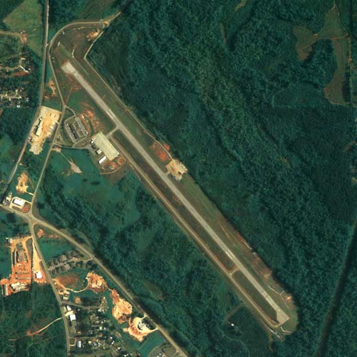
Mac Crenshaw Memorial Airport (ICAO: KPRN, FAA LID: PRN) is a city-owned public-use airport located 2 nautical miles (4 km) northeast of the central business district of Greenville, a city in Butler County, Alabama, United States.
Although most U.S. airports use the same three-letter location identifier for the FAA and IATA, this airport is assigned PRN by the FAA but has no designation from the IATA.
Facilities and aircraft
Mac Crenshaw Memorial Airport covers an area of 89 acres (36 ha) at an elevation of 451 feet (137 m) above mean sea level. It has one asphalt paved runway designated 14/32 which measures 5,500 by 80 ft. (1,676 by 24 m). For the 12-month period ending September 13, 2006, the airport had 4,274 aircraft operations, an average of 11 per day: 88% general aviation and 12% military.
The above content comes from Wikipedia and is published under free licenses – click here to read more.
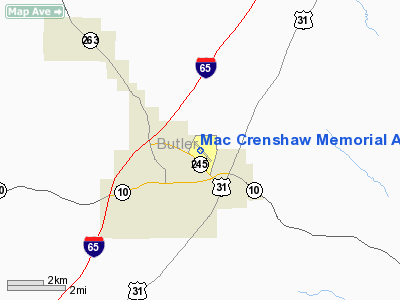
Location
& QuickFacts
|
FAA Information Effective: |
2007-01-18 |
|
Airport
Identifier: |
PRN |
|
Airport
Status: |
Operational |
|
Longitude/Latitude: |
086-36-38.6560W/31-50-44.4980N
-86.610738/31.845694 (Estimated) |
|
Elevation: |
451 ft / 137.46 m (Surveyed) |
|
Land: |
89
acres |
|
From
nearest city: |
2 nautical miles NE of Greenville, AL |
|
Location: |
Butler County, AL |
|
Magnetic Variation: |
00E (1985) |
Owner
& Manager
|
Ownership: |
Publicly owned |
|
Owner: |
City Of Greenville |
|
Address: |
Po Box 158
Greenville, AL 36037 |
|
Phone number: |
334-382-2647 |
|
Manager: |
Travis Capps |
|
Address: |
117 Commander Drive
Greenville, AL 36037 |
|
Phone number: |
334-382-8166 |
Airport
Operations and Facilities
|
Airport Use: |
Open to public |
|
Wind
indicator: |
Yes |
|
Segmented
Circle: |
Yes |
|
Control
Tower: |
No |
|
Lighting
Schedule: |
DUSK-DAWN
ACTVT MIRL RY 14/32 AND PAPI AND REIL RYS 14 & 32 -
CTAF. |
|
Beacon
Color: |
Clear-Green (lighted land airport) |
|
Landing
fee charge: |
No |
|
Sectional
chart: |
New Orleans |
|
Region: |
ASO - Southern |
|
Boundary
ARTCC: |
ZTL - Atlanta |
|
Tie-in
FSS: |
ANB - Anniston |
|
FSS
on Airport: |
No |
|
FSS
Toll Free: |
1-800-WX-BRIEF |
|
NOTAMs
Facility: |
ANB (NOTAM-d service avaliable) |
|
Federal Agreements: |
NGY |
Airport
Communications
|
CTAF: |
122.800 |
|
Unicom: |
122.800 |
Airport
Services
|
Fuel available: |
100LLA
FOR FUEL AFTER HRS CALL 334-382-2809 OR 334-335-5950; SVC
CHARGE. |
|
Airframe Repair: |
MAJOR |
|
Power Plant Repair: |
MAJOR |
|
Bottled
Oxygen: |
NONE |
|
Bulk
Oxygen: |
NONE |
|
Runway Information
Runway 14/32
|
Dimension: |
5500 x 80 ft / 1676.4 x 24.4 m |
|
Surface: |
ASPH, Good Condition |
|
Weight
Limit: |
Single wheel: 15000 lbs. |
|
Edge
Lights: |
Medium |
|
|
Runway 14 |
Runway 32 |
|
Longitude: |
086-36-59.2883W |
086-36-18.0239W |
|
Latitude: |
31-51-05.2499N |
31-50-23.7469N |
|
Elevation: |
452.00
ft |
424.00
ft |
|
Alignment: |
127 |
127 |
|
Traffic
Pattern: |
Left |
Left |
|
Markings: |
Non-precision instrument, Good Condition |
Non-precision instrument, Good Condition |
|
Crossing
Height: |
40.00
ft |
40.00
ft |
|
Displaced
threshold: |
0.00 ft |
300.00
ft |
|
VASI: |
2-light PAPI on left side |
2-light PAPI on left side |
|
Visual
Glide Angle: |
3.00° |
3.00° |
|
Runway
End Identifier: |
Yes |
Yes |
|
Obstruction: |
25 ft tree, 1059.0 ft from runway, 10 ft left
of centerline, 33:1 slope to clear |
18 ft trees, 255.0 ft from runway, 39 ft right
of centerline, 3:1 slope to clear
RY 32 OBSTN CLNC SLOPE 30:1 FM DISP THLD. |
|
Decleard
distances: |
Take off run available 5200.00 ft
Take off distance available 5500.00 ft
Actual stop distance available 5200.00 ft
Landing distance available 5200.00 ft |
Take off run available 5500.00 ft
Take off distance available 5500.00 ft
Actual stop distance available 5500.00 ft
Landing distance available 5200.00 ft |
|
Radio Navigation
Aids
|
ID |
Type |
Name |
Ch |
Freq |
Var |
Dist |
|
PRN |
NDB |
Persimmon/dcmsnd |
|
359.00 |
00E |
0.4 nm |
|
XBR |
NDB |
Brantley |
|
410.00 |
00E |
23.6 nm |
|
TO |
NDB |
Blood |
|
365.00 |
01W |
25.8 nm |
|
SE |
NDB |
Pollk |
|
344.00 |
01W |
30.2 nm |
|
XNE |
NDB |
Spring Hill |
|
281.00 |
00E |
33.9 nm |
|
JUY |
NDB |
Judd |
|
264.00 |
02W |
34.4 nm |
|
BVG |
NDB |
Boll Weevil |
|
352.00 |
03E |
44.4 nm |
|
MXF |
TACAN |
Maxwell |
097X |
|
03E |
34.4 nm |
|
UIA |
VOR |
Andalusia |
|
110.20 |
00E |
34.1 nm |
|
EDN |
VOR |
Enterprise |
|
116.60 |
03W |
49.0 nm |
|
JYU |
VOR/DME |
Junior |
083X |
113.60 |
01W |
35.7 nm |
|
MGM |
VORTAC |
Montgomery |
058X |
112.10 |
03E |
27.1 nm |
|
MVC |
VORTAC |
Monroeville |
115X |
116.80 |
04E |
44.5 nm |
Remarks
- PAEW
ADJ RY 14/32 INDEFLY.
- ARPT
BUILT BEFORE FAA ACT
Based
Aircraft
|
Aircraft
based on field: |
7 |
|
Single
Engine Airplanes: |
6 |
|
Multi
Engine Airplanes: |
1 |
Operational Statistics
Time Period: 2005-09-14
- 2006-09-13
|
Aircraft
Operations: |
83/Week |
|
General
Aviation Local: |
13.3% |
|
General
Aviation Itinerant: |
75.0% |
|
Military: |
11.7% |
Mac Crenshaw Memorial Airport
Address:
Butler County, AL
Tel:
334-382-2647, 334-382-8166
Images
and information placed above are from
http://www.airport-data.com/airport/PRN/
We
thank them for the data!
| General
Info |
| Country |
United
States |
| State |
ALABAMA
|
| FAA ID |
PRN
|
| Latitude |
31-50-43.448N
|
| Longitude |
086-36-37.605W
|
| Elevation |
449 feet
|
| Near City |
GREENVILLE
|
We don't guarantee the information is fresh and accurate. The data may
be wrong or outdated.
For more up-to-date information please refer to other sources.
|
|


