 |
|
|
|
|
|
Location
& QuickFacts
| FAA Information Effective: |
2005-10-27 |
| Airport Identifier: |
3AL4 |
| Longitude/Latitude: |
086-16-05.0000W/32-24-49.0000N
-86.268056/32.413611 (Estimated) |
| Elevation: |
221
ft / 67.36 m (Estimated) |
| Land: |
1
acres |
| From nearest city: |
2
nautical miles NE of Montgomery, AL |
| Location: |
Montgomery
County, AL |
| Magnetic Variation: |
01W
(1995) |
Owner
& Manager
| Ownership: |
Privately
owned |
| Owner: |
Alabama
Dept Of Transportation |
| Address: |
1525
Coliseum Blvd.
Montgomery, AL 36110 |
| Phone number: |
334-242-6333 |
| Manager: |
William
H. Sherlock, Jr.
SAFETY DIRECTOR. |
| Address: |
1409
Coliseum Blvd.
Montgomery, AL 36130-3050 |
| Phone number: |
334-242-6333 |
Airport
Operations and Facilities
| Airport Use: |
Private |
| Segmented Circle: |
No |
| Control Tower: |
No |
| Attendance Schedule: |
UNATNDD |
| Sectional chart: |
Atlanta |
| Region: |
ASO
- Southern |
| Boundary ARTCC: |
ZTL
- Atlanta |
| Tie-in FSS: |
ANB
- Anniston |
| FSS Phone: |
256-832-2100 |
| FSS Toll Free: |
1-800-WX-BRIEF |
Runway
Information
Helipad
H1
| Dimension: |
22
x 22 ft / 6.7 x 6.7 m |
| Surface: |
CONC,
|
| |
Runway
H1 |
Runway
|
| Traffic Pattern: |
Left |
Left |
|
Radio
Navigation Aids
| ID |
Type |
Name |
Ch |
Freq |
Var |
Dist |
| GGY |
NDB |
Gragg-wade |
|
338.00 |
01E |
31.6
nm |
| DER |
NDB |
Alexander
City |
|
382.00 |
01W |
32.0
nm |
| SE |
NDB |
Pollk |
|
344.00 |
01W |
34.6
nm |
| TO |
NDB |
Blood |
|
365.00 |
01W |
36.0
nm |
| PRN |
NDB |
Persimmon/dcmsnd |
|
359.00 |
00E |
38.1
nm |
| SCD |
NDB |
Sylacauga |
|
284.00 |
03W |
45.8
nm |
| XNE |
NDB |
Spring
Hill |
|
281.00 |
00E |
46.3
nm |
| MXF |
TACAN |
Maxwell |
097X |
|
03E |
5.5
nm |
| TGE |
VOR/DME |
Tuskegee |
120X |
117.30 |
02E |
30.7
nm |
| JYU |
VOR/DME |
Junior |
083X |
113.60 |
01W |
36.9
nm |
| MGM |
VORTAC |
Montgomery |
058X |
112.10 |
03E |
11.8
nm |
Remarks
50 FT POWER LINE 165 FT NORTHWEST, 30 FT TREES 65 FT SOUTHWEST OF
HELIPAD.
PRVDD ALL OPNS ARE CONDUCTED IN VFR WEATHER CONDITIONS AND LNDG AREA
IS LIMITED TO PVT USE ONLY.
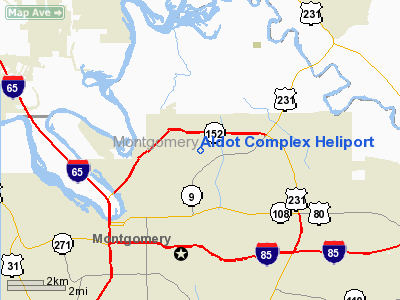
Aldot Complex Heliport
Montgomery
County, AL
Tel: 334-242-6333
Images and information placed above are from
http://www.airport-data.com/airport/3AL4/
We thank them for the data!
| General Info
|
| Country |
United States
|
| State |
ALABAMA
|
| FAA ID |
3AL4
|
| Latitude |
32-24-49.000N
|
| Longitude |
086-16-05.000W
|
| Elevation |
221 feet
|
| Near City |
MONTGOMERY
|
We don't guarantee the information is fresh and accurate. The data may be wrong or outdated.
For more up-to-date information please refer to other sources.
|
|


