 |
|
|
|
 |
|
 Description
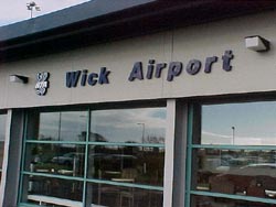
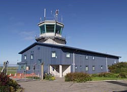
Located on the northern edge of the town, Wick airport supports vital business and leisure travel for the Caithness community. It regularly attracts oil-related helicopter operations and a large number of ferry flights which use Wick as a stop-over en route to and from Europe via Iceland. Aircraft operations are supported by an Air Traffic Control Service while on call services to air ambulance and search and rescue flights are assisted by a Flight Information Service Officer. An Airport Fire Service is provided on the basis of a Rescue and Fire Fighting Service category 4 airport as detailed in Civil Aviation Publication 168.
Cafe
Flight Bite serves light meals, tea, coffee, home baking, newspapers, stamps and cigarettes with a drinks licence available from 11.00 o'clock.
Disabled Facilities
There are two designated car park spaces for disabled parking and one drop off bay. There is a disabled toilet with an alert fitted to attract assistance if necessary.
 Nursing Room
There is a nappy changing unit, nappy disposal unit, a bottle warmer and wash hand basin available at the terminal building.
Post Box
There is a post box at the airport with mail collected once daily.
Public Transportation
The bus station and train station are situated near Wick town centre, approximately 1.5 miles from the airport. Trains are available to Thurso and Inverness (and all intermediate stations). Buses are available to most towns and villages in Caithness as well as Scottish Citylink services to Inverness.
Airport Tel No +44 (0) 1955 602294
Airport Address - Wick Airport, Wick, Caithness
Ticket Sales - British Airways Ticket Desk
Check-in - British Airways
Car Hire - Practical Car Hire +44 (0)1955 604125
Taxi Services - Details are available at the airport terminal
Train Services - The train station is 1.5 miles from the airport, and there are services to Thurso and Inverness
Wick Airport
Wick
Caithness
KW1 4QP
Enquiry Desk 01955 602215
Airport code - WIC
WWW: http://www.hial.co.uk/wick-airport.html
Images and information placed above are from
http://www.photo-tech.co.uk/travel_air_wick/P5266377.html
http://www.loganair.co.uk/wick_airport.htm
http://www.scottishflightguide.co.uk/wickairport.htm
We thank them for the data!
| General Info
|
| Country |
United Kingdom
|
| ICAO ID |
EGPC
|
| Time |
UTC 0(+1DT)
|
| Latitude |
58.458756
58° 27' 31.52" N
|
| Longitude |
-3.092964
003° 05' 34.67" W
|
| Elevation |
126 feet
38 meters
|
| Magnetic Variation |
005° W (01/05)
|
| Operating Agency |
CIVIL GOVERNMENT, (LANDING FEES AND DIPLOMATIC CLEARANCE MAY BE REQUIRED)
|
| Operating Hours |
SEE REMARKS FOR OPERATING HOURS OR COMMUNICATIONS FOR POSSIBLE HOURS
|
| Daylight Savings Time |
Last Sunday in March to last Sunday in October
|
| Communications
|
| TWR |
119.7
|
ATIS
Opr 0650-1830Z++Mon-Fri; 0820-1445Z++Sat.
|
113.6
|
| APP |
119.7
|
| INFO |
119.7
|
| Runways
|
| ID |
Dimensions |
Surface |
PCN |
ILS
|
| 08/26 |
3399 x 148 feet
1036 x 45 meters |
ASPHALT |
- |
NO
|
| 13/31 |
5988 x 148 feet
1825 x 45 meters |
ASPHALT |
016FAWT |
NO
|
| Navaids
|
| Type |
ID |
Name |
Channel |
Freq |
Distance From Field |
Bearing From Navaid
|
| VOR-DME |
WIK |
WICK |
083X |
113.6 |
At Field |
-
|
| NDB |
WIK |
WICK |
- |
344 |
1.2 NM |
313.2
|
| Supplies/Equipment
|
| Fuel |
Jet A1, without icing nhibitor.
100/130 MIL Spec, low lead, aviation gasoline (BLUE)
|
| Oil |
O-123, 1065,(Dispersant)Reciprocating Engine Oil(MIL L 22851 Type III)
O-133, 1010, jet Engine Oil (MIL l 6081)
|
| Remarks
|
| CAUTION |
Rwy 08-26 may be slippery due to moss growth. Road cros apch end Rwy 31.
|
| FUEL |
(NC-100LL, A1) Avbl dur opr hr, OT by arng to FAR NORTH WICK. Call FARNOR 130.375.
|
| JASU |
1(E12)
|
| LGT |
PAPI Rwy 08 GS 4 MEHT 32', PAPI Rwy 26 GS 4 MEHT 27', PAPI Rwy 13-31 MEHT 25'.
|
| OIL |
O-117-123-128-133-149-156
|
| OPR HOURS |
Opr 0745-1830++ Mon-Fri, 0845-1030 and 1100-1445Z++Sat, OT by arng.
|
| RSTD |
3 hr PPR rqr.
|
| RWY |
Fst 2000' of Rwy 08 has 1 upslope. Rpt LDA for Rwy 13 is 4593'. Rpt LDA for Rwy31 is 4587'.
|
Runway 08/26
3399 x 148 feet
1036 x 45 meters
| Runway 08
|
| Surface |
ASPHALT
|
| True Heading |
076.0
|
| Latitude |
58.455817
58° 27' 20.94" N
|
| Longitude |
-3.101606
003° 06' 05.78" W
|
| Elevation |
99.0 feet
30 meters
|
| Slope |
0.4°
|
| Landing Distance |
3399 feet
1036 meters
|
| Takeoff Distance |
3399 feet
1036 meters
|
| Lighting System |
LIRL
PAPI
PORTABLE
LIGHTS |
| Runway 26
|
| Surface |
ASPHALT
|
| True Heading |
256.0
|
| Latitude |
58.458150
58° 27' 29.34" N
|
| Longitude |
-3.084417
003° 05' 03.90" W
|
| Elevation |
113.0 feet
34 meters
|
| Slope |
-0.4°
|
| Landing Distance |
3399 feet
1036 meters
|
| Takeoff Distance |
3399 feet
1036 meters
|
| Lighting System |
LIRL
PAPI
PORTABLE
LIGHTS |
Runway 13/31
5988 x 148 feet
1825 x 45 meters
| Runway 13
|
| Surface |
ASPHALT
|
| True Heading |
127.0
|
| Latitude |
58.463689
58° 27' 49.28" N
|
| Longitude |
-3.105469
003° 06' 19.69" W
|
| Elevation |
114.0 feet
35 meters
|
| Slope |
0.0°
|
| Landing Distance |
5168 feet
1575 meters
|
| Takeoff Distance |
5988 feet
1825 meters
|
| Displaced Threshold Length |
820 feet
250 meters
|
| Lighting System |
HIRL
S
PAPI |
| Runway 31
|
| Surface |
ASPHALT
|
| True Heading |
307.0
|
| Latitude |
58.453808
58° 27' 13.71" N
|
| Longitude |
-3.080433
003° 04' 49.56" W
|
| Elevation |
114.0 feet
35 meters
|
| Slope |
0.0°
|
| Landing Distance |
4971 feet
1515 meters
|
| Takeoff Distance |
5988 feet
1825 meters
|
| Displaced Threshold Length |
1017 feet
310 meters
|
| Lighting System |
HIRL
S
PAPI |
Navaids
| WICK
|
| Type |
ID |
Channel |
Freq |
Country |
State
|
| VOR-DME |
WIK |
083X |
113.6 |
United Kingdom |
-
|
| Latitude |
Longitude |
Airport
|
58.458889
58° 27' 32.00" N |
-3.100278
003° 06' 01.00" W |
EGPC
|
Navaids
| WICK
|
| Type |
ID |
Channel |
Freq |
Country |
State
|
| NDB |
WIK |
- |
344 |
United Kingdom |
-
|
| Latitude |
Longitude |
Airport
|
58.446731
58° 26' 48.23" N |
-3.063119
003° 03' 47.23" W |
EGPC
|
The content above was published at Airports-Worldwide.com in 2005.
We don't guarantee the information is fresh and accurate. The data may be wrong or outdated.
For more up-to-date information please refer to other sources.
|
|


