 |
 |
|
||||
|
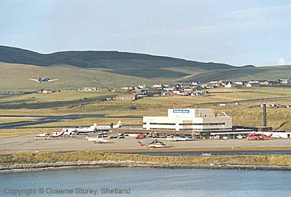
Sumburgh Airport is located at the southern tip of the Shetland Islands and is made easily accessible through regular flights to/from main connecting Scottish cities. You can travel via Edinburgh, Glasgow, Inverness or Aberdeen - with connections available throughout the UK and international airport network. Aircraft operations are supported by an Air Traffic Control service while on call services to air ambulance and search and rescue flights are assisted by a Flight Information Officer. An Airport Fire Service is provided on the basis of a Rescue and Fire Fighting Service category 5 airport as detailed in Civil Aviation Publication 168. Shop and Cafe There is a combined shop and cafe situated in the main terminal building which offers a selection of local souvenirs, confectionery, hot and cold food and beverages and alcoholic drinks. Facilities BT payphones are available throughout the terminal building and the Tourist Information Point provides a computer for internet and Email access. A wide-screen television is located in the main lounge area. Facilities for the Disabled Disabled toilets are provided within the main terminal building and wheelchairs are available. If you require assistance please make arrangements prior to arrival through the flight operator or by contacting airport administration staff who will be happy to assist on tel: +44 (0) 1950 461000. Ambulift facilities are available to assist passengers with impaired mobility during embarkation and disembarkation from aircraft. There are ramp facilities at the entrance. Meeting Rooms and Lounge Facilities Various conference facilities are available for hire within the main terminal building. Please contact the airport administration office for details on tel: +44 (0) 1950 461000. A prayer room and separate quiet room are located in the main termainl building. Please contact the airport administration office for details on tel: +44 (0) 1950 461000. Helicopter and Charter Flights
Helicopter Charter
Images and information placed above are from http://www.azworldairports.com/cfm/frame.cfm?src=http://www.azworldairports.com/airports/p2720lsi.htm http://www.shetlandtourism.com/pages/getting_to_shetland.htm http://www.worldtour-of-scotland.com/tour/31jul-arrival-shetland.shtml http://www.shetland.gov.uk/splan/tra.htm We thank them for the data!
Runway 06/241804 x 148 feet
Effective 17 February 2005 to 16 March 2005
|
|||||||||||||||||||||||||||||||||||||||||||||||||||||||||||||||||||||||||||||||||||||||||||||||||||||||||||||||||||||||||||||||||||||||||||||||||||||||||||||||||||||||||||||||||||||||||||||||||||||||||||||||||||||||||||||||||||||||||||||||||||||||||||||||||||||||||||||||||||||||||||||
| Runway 06 | |
|---|---|
| Surface | ASPHALT |
| True Heading | 055.0 |
| Latitude | 59.875556 59° 52' 32.00" N |
| Longitude | -1.288056 001° 17' 17.00" W |
| Elevation | 9.0 feet 3 meters |
| Slope | 0.6° |
| Landing Distance | 1804 feet 550 meters |
| Takeoff Distance | 1804 feet 550 meters |
| Lighting System | LIRL |
| Runway 24 | |
|---|---|
| Surface | ASPHALT |
| True Heading | 235.0 |
| Latitude | 59.878056 59° 52' 41.00" N |
| Longitude | -1.280833 001° 16' 51.00" W |
| Elevation | 19.0 feet 6 meters |
| Slope | -0.6° |
| Landing Distance | 1804 feet 550 meters |
| Takeoff Distance | 1804 feet 550 meters |
| Lighting System | LIRL |
| Runway 09 | |
|---|---|
| Surface | ASPHALT |
| True Heading | 084.0 |
| Latitude | 59.880822 59° 52' 50.96" N |
| Longitude | -1.305261 001° 18' 18.94" W |
| Elevation | 20.0 feet 6 meters |
| Slope | -0.1° |
| Landing Distance | 3848 feet 1173 meters |
| Takeoff Distance | 3871 feet 1180 meters |
| Displaced Threshold Length | 23 feet 7 meters |
| Lighting System | HIRL
M PAPI |
| Runway 27 | |
|---|---|
| Surface | ASPHALT |
| True Heading | 264.0 |
| Latitude | 59.882014 59° 52' 55.25" N |
| Longitude | -1.284325 001° 17' 03.57" W |
| Elevation | 15.0 feet 5 meters |
| Slope | 0.1° |
| Landing Distance | 3766 feet 1148 meters |
| Takeoff Distance | 3871 feet 1180 meters |
| Displaced Threshold Length | 105 feet 32 meters |
| Lighting System | HIRL
M PAPI |
| Runway 15 | |
|---|---|
| Surface | ASPHALT |
| True Heading | 144.0 |
| Latitude | 59.881864 59° 52' 54.71" N |
| Longitude | -1.300489 001° 18' 01.76" W |
| Elevation | 7.0 feet 2 meters |
| Landing Distance | 4064 feet 1239 meters |
| Takeoff Distance | 4678 feet 1426 meters |
| Displaced Threshold Length | 614 feet 187 meters |
| Lighting System | HIRL
PAPI |
| Runway 33 | |
|---|---|
| Surface | ASPHALT |
| True Heading | 324.0 |
| Latitude | 59.871589 59° 52' 17.72" N |
| Longitude | -1.285303 001° 17' 07.09" W |
| Elevation | 8.0 feet 2 meters |
| Landing Distance | 4064 feet 1239 meters |
| Takeoff Distance | 4678 feet 1426 meters |
| Displaced Threshold Length | 614 feet 187 meters |
| Lighting System | HIRL |
| SUMBURGH | |||||
|---|---|---|---|---|---|
| Type | ID | Channel | Freq | Country | State |
| VOR-DME | SUM | 120Y | 117.35 | United Kingdom | - |
| Latitude | Longitude | Airport |
| 59.878889 59° 52' 44.00" N |
-1.286667 001° 17' 12.00" W |
EGPB |
The content above was published at Airports-Worldwide.com in 2005.
We don't guarantee the information is fresh and accurate. The data may be wrong or outdated.
For more up-to-date information please refer to other sources.

 |
|
Copyright 2004-2024 © by Airports-Worldwide.com, Vyshenskoho st. 36, Lviv 79010, Ukraine Legal Disclaimer |
 Car Parking
 Sumburgh Airport