 |
|
Erkilet Havaalani
Kayseri Erkilet Airport
Erkilet International Airport |
 |
IATA: ASR – ICAO: LTAU
+
Kayseri Erkilet Airport
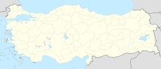
Location of airport in Turkey
|
| Summary |
| Airport type |
Military/Public |
| Operator |
DHMİ (State Airports Administration)
 Turkish Air Force Turkish Air Force |
| Location |
Kayseri, Turkey |
| Elevation AMSL |
3,506 ft / 1,069 m |
| Coordinates |
38°46′13″N 035°29′43″E / 38.77028°N 35.49528°E / 38.77028; 35.49528 (Erkilet International Airport)Coordinates: 38°46′13″N 035°29′43″E / 38.77028°N 35.49528°E / 38.77028; 35.49528 (Erkilet International Airport) |
| Runways |
| Direction |
Length |
Surface |
| m |
ft |
| 07/25 |
3,000 |
9,841 |
Concrete |
| Sources: DHMİ,Turkish AIP at EUROCONTROL |
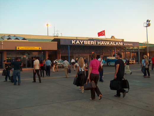
Erkilet terminal from the apron Erkilet Airport or Kayseri Erkilet Airport (Turkish: Kayseri Erkilet Havaalanı) (IATA: ASR, ICAO: LTAU) is a military airbase and public airport located 5 km (3.1 mi) north of Kayseri in the Kayseri Province of Turkey.
The airport is able to accommodate jets the size of the Boeing 747. However, smaller jets like the Boeing 737 and Boeing 757 are more commonly seen there.
The prior capacity of the airport was 600,000 passengers per year. With the opening of the new international terminal in March 2007, its total capacity increased up to 1 million passengers per year.
A number of cargo airlines operate to and from Erkilet. As a passenger airport, Erkilet serves a culturally and historically rich part of Turkey.
Airlines and destinations
| Airlines |
Destinations |
| Amsterdam Airlines |
Amsterdam, Maastricht |
| Anadolujet |
Izmir |
| Arkefly |
Amsterdam |
| Corendon Airlines |
Amsterdam, Billund, Copenhagen, Rotterdam |
| Freebird Airlines |
Stuttgart |
| Germania |
Berlin-Tegel |
| Hamburg International |
Munich |
| Pegasus Airlines |
Düsseldorf, Istanbul-Sabiha Gökçen, Stuttgart, Vienna |
| Sky Airlines |
Antalya, Hamburg |
| SunExpress |
Izmir, Istanbul-Sabiha Gökçen |
| Turkish Airlines |
Amsterdam, Düsseldorf, Istanbul-Atatürk |
| XL Airways Germany |
Hannover, Frankfurt |
The above content comes from Wikipedia and is published under free licenses – click here to read more.
| General Info
|
| Country |
Turkey
|
| ICAO ID |
LTAU
|
| Time |
UTC+2(+3DT)
|
| Latitude |
38.770386
38° 46' 13.39" N
|
| Longitude |
35.495428
035° 29' 43.54" E
|
| Elevation |
3463 feet
1056 meters
|
| Type |
Joint (Civil and Military)
|
| Magnetic Variation |
004° E (01/06)
|
| Beacon |
Yes
|
| Operating Agency |
MILITARY - CIVIL JOINT USE AIRPORT
|
| Near City |
Kayseri
|
| Communications
|
| TWR |
122.1
257.8
|
| GND |
121.95
251.25
|
| APP |
122.1
362.3
|
| Runways
|
| ID |
Dimensions |
Surface |
PCN |
ILS
|
| 07/25 |
9841 x 145 feet
3000 x 44 meters |
CONCRETE. |
- |
YES
|
| Navaids
|
| Type |
ID |
Name |
Channel |
Freq |
Distance From Field |
Bearing From Navaid
|
| TACAN |
KSR |
KAYSERI |
116X |
- |
At Field |
-
|
| VOR-DME |
KSR |
KAYSERI |
110X |
116.3 |
1.3 NM |
251.5
|
| Supplies/Equipment
|
| Fuel |
JP-4, Wide cut turbine fuel MIL Spec T-5624
115/145 octane gasoline, leaded, MIL-L-5572F (PURPLE)
|
| Oil |
O-128, 1100,(Dispersant)Reciprocating Engine Oil(MIL L 22851 Type II)
O-148, MIL L 7808 (Synthetic Base), Turboprop/Turboshaft Engine
|
| Other Fluids |
LPHOX, Low pressure oxygen servicing
LOX, Liquid oxygen servicing
|
| JASU |
MA-1A
82lb/min (1123cfm) at 130 deg air inlet temp,45psia(min) air outlet
MD-3A
AC:115/208v, 400 cycle, 3 phase, 60 kva, 0.75 pf, 4 wire, DC:28v, 1500 amp, 45 kw, split bus
U-1000
DC 600 1200 amp 28v
|
| Remarks
|
| FLUID |
LPOX LOX
|
| FUEL |
(N/C J4, J8)
|
| JASU |
1(A-1) 1(MA-1A) 1(MD-3) 1(MD-3A) 1(U-1000)
|
| OIL |
O-128-148
|
| OPR HOURS |
Opr by NOTAM.
|
| RSTD |
48 PPR due ltd prk avbl.
|
| TRAN ALERT |
Svc avbl.
|
The content above was published at Airports-Worldwide.com in 2010.
We don't guarantee the information is fresh and accurate. The data may be wrong or outdated.
For more up-to-date information please refer to other sources.
|
|


