|
|
Svalbard Airport, Longyear
Svalbard lufthavn, Longyear |
 |
| IATA: LYR – ICAO: ENSB |
| Summary |
| Airport type |
Public |
| Owner/Operator |
Avinor |
| Serves |
Svalbard |
| Location |
Longyearbyen, Norway |
| Elevation AMSL |
88 ft / 27 m |
| Coordinates |
78°14′46″N 15°27′56″E / 78.24611°N 15.46556°E / 78.24611; 15.46556 |
| Runways |
| Direction |
Length |
Surface |
| m |
ft |
| 10/28 |
2,323 |
7,621 |
Asphalt |
| Statistics (2009) |
| Passengers |
138,934 |
Svalbard Airport, Longyear (IATA: LYR, ICAO: ENSB) (Norwegian: Svalbard lufthavn, Longyear) is the main airport serving Svalbard in Norway. It is located 1.6 nautical miles (3 km) northwest of Longyearbyen, and it is the northernmost airport in the world with public scheduled flights. The first airport near Longyearbyen was constructed during World War II. In 1959, it was first taken into use for occasional flights, but could only be used a few months a year. Construction of the new airport at Hotellneset started in 1973, and the airport was opened on 2 September 1975. It is owned and operated by state-owned Avinor.
In 2009, the airport had 138,934 passengers. Scandinavian Airlines System operates daily flights to Tromsø and Oslo on mainland Norway. Lufttransport provides services to the two other airports on Svalbard: Ny-Ålesund and Svea, using Dornier Do 228 turboprop aircraft. There are also regular charter flights. History
Adventdalen
The first air strip on Svalbard was constructed in Adventdalen, near Longyearbyen, by the Luftwaffe during World War II. This was not used after the war; during the summer the archipelago was served by ships, but was completely isolated from November to May. In the early 1950s, the Norwegian Air Force started postal flights using a Catalina aircraft that departed from Tromsø and dropped postal parcels at Bear Island and at Longyearbyen. However, these aircraft never landed until 9 February 1959, when a resident had become seriously ill, and needed to be flown to mainland Norway for treatment. The mining company Store Norske Spitsbergen Kullkompani cleared the runway at Adventsdalen and the 14-hour flight and landing was successful. A second landing, this time for delivery of post, was made on 11 March.
While the Catalina was suitable for postal flights, it was not suitable for a permanent solution for transporting passengers and freight, mainly due to its small size. Store Norske contacted the domestic airline Braathens SAFE for a regular service. The first trial flight was made on 2 April 1959 with a Douglas DC-4 with 54 passengers from Bardufoss Airport. Store Norske cleared a 1,800 by 40 metres (5,900 by 130 ft) runway for the aircraft. The next flight was done in 1962, followed by one in 1963 and two in 1964. Due to lack of runway lights, flights could only be done during daylight, thus hindering flights during parts of December and January, when the sun never rises. By April, the runway could melt, and no flights could be done during summer. Navigation was conducted using radio signals from Bear Island and Isfjord.
The first night landing was made on 8 December 1965. The DC-4 took off from the new Tromsø Airport and dropped mail at Bear Island before continuing to Longyearbyen. The runway was lit up using paraffin lamps and lights from cars parked along the runway. A radio sender was also installed at Hotellneset. During the 1965–66 season, Braathens SAFE made 16 flights to Svalbard. The following two seasons, the contract was awarded to Scandinavian Airlines System (SAS), but after that they reverted back to Braathens SAFE. Fred Olsen Air Transport made its first flight to Svalbard in 1966. By 1969, a total of 50 flights had been made to Svalbard, and by 1972, the 100th was made. By then, Braathens SAFE had started using Douglas DC-6B aircraft. During these years, Store Norske also installed permanent lights. The first jet plane, a Fokker F-28, landed on 29 April 1972. From 1974, Boeing 737-200C aircraft were taken into use. It had a side cargo door, allowing easy loading of cargo into the main cabin. Braathens SAFE built a small depot with spare parts and up to 90,000 litres (20,000 imp gal; 24,000 US gal) fuel. Aeroflot started flights to Adventdalen in 1973 to serve the neighboring Russian community of Barentsburg.
Hotellneset
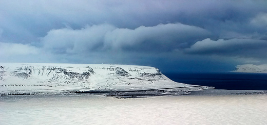 | |
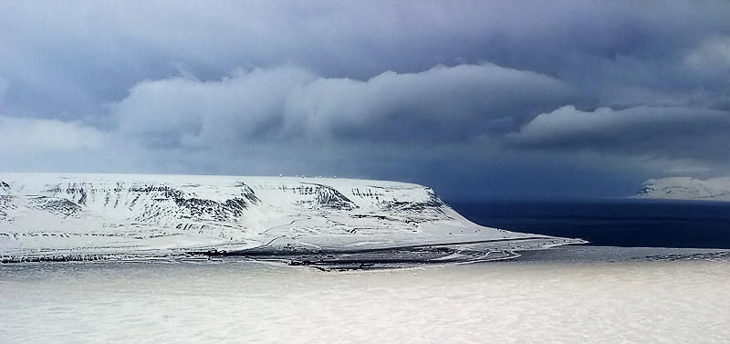
View of Svalbard Airport |
The Svalbard Treaty specifies that no military installations are permitted on the archipelago. The Soviet authorities were concerned that a permanent civilian airport could also be used by Norwegian and NATO forces. But the Soviets also needed an airport to serve their settlements at Barentsburg and Pyramiden, and by the early 1970s, an understanding was reached between the two countries.
Construction started in 1973. The airport needed to be built on permafrost. The runway is insulated against the ground, so it will not melt during the summer. The hanger is frozen into the ground, with the pillars being melted into place and then being frozen stuck. The runway was plagued with frost heave due to an incorrect construction method, forcing the airport to regularly have to re-asphalt the runway. In 1989, parts of the runway were re-insulated, giving these areas that previously had been the worst an acceptable solution. In 2006, this measure was conducted on the remaining parts of the runway. An upgrade to the terminal building to allow larger capacity was completed in 2007.
Services
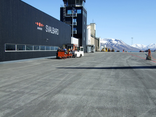 | |
The newest part of the airport, which opened in 2007 |
Both Braathens SAFE and SAS applied for the concession to fly from the mainland to Norway. This was granted to SAS, who would have one weekly service. From the airport was taken into use until the official opening, Braathens SAFE continued to fly charter flights for Store Norske. The first landing at the new airport was made on 14 September 1974 with a Fokker F-28, and Braathens SAFE continued to fly until 1 September 1975. Russian authorities granted a concession for a semi-weekly service by Aeroflot from Murmansk Airport. The first attempt to officially open the airport was made with a SAS Douglas DC-9 on 14 August 1975. Among the guests on board was King Olav V, but thick fog at Longyearbyen forced the airplane to return. On 1 September, a Fokker F-27 from Braathens SAFE was used to calibrate the runways; on board were pilots from SAS and Aeroflot to learn about the landing conditions. The following day, the second attempt to open the airport was successful. In addition to the scheduled services, Store Norske chartered cargo flights from Fred Olsen Air Transport.
Lufttransport has been at the airport since 1976. In 1984, two Bell 212 helicopters were stationed at the airport on contract with the Governor of Svalbard. The company signed an agreement with the Norwegian Coast Guard to have a Partenavia Spartacus planes stationed at Longyearbyen for fishery surveillance. Since 1994, the company has had a Dornier Do 228 stationed at the airport, and two since 2001.
On 14 August 1987, Braathens SAFE re-entered the market, flying in parallel with SAS to Tromsø and Oslo. For the first time, the scheduled flights to Oslo were offered as day flights instead of the night flights offered by SAS. In 2002, after SAS bought Braathens, the subsidiary took over all flights to Longyearbyen for the group. From May 2004, they merged to SAS Braathens, that again became SAS from 1 June 2007. From 1 April to 1 November 2004, Norwegian Air Shuttle introduced three weekly services to Longyearbyen to Tromsø and Oslo, using Boeing 737-300 aircraft, but the service was terminated due to low loads. A new service was started on 27 March 2008, with two direct services to Oslo, using larger Boeing 737-800 aircraft., but again the route was terminated later the same year.
Facilities
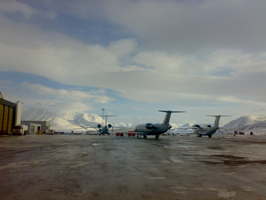 | |
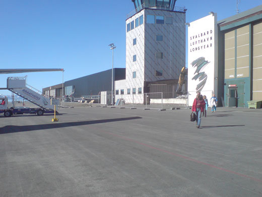
Aircraft parked at the airport |
The airport is located 1.6 nautical miles (3.0 km; 1.8 mi) northwest of Longyearbyen, the largest settlement on Svalbard. The airport also serves the near-by Russian settlement of Barentsburg. Although mainland Norway is part of the Schengen Area, while Svalbard is excluded, there is no passport control.
There are 200 free outdoor parking spaces at the airport. There are taxis, rental cars and airport coaches available at the airport. Scandinavian Airlines provides handling services through SAS Ground Services.
The runway is 2,323 metres (7,621 ft) long and aligned 10/28 (roughly east–west), equipped with instrument landing system, but there are no taxiways. The 45 metres (148 ft) wide runway has two culverts that allow water from the mountain Platåberget to drain under it. About one third of the runway is dug into the terrain, while about two-thirds is built on an embankment. A layer of frost-stable fill, varying from 1 to 4 metres (3 ft 3 in to 13 ft 1 in) is under the runway to hinder the soil from unfreezing during summer.
Airlines and destinations
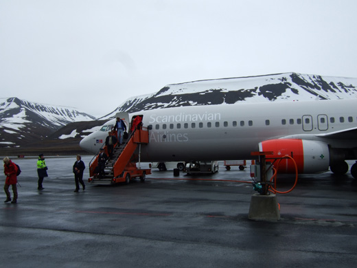 | |
Passengers disembarking a Scandinavian Airlines Boeing 737-800 |
| Airlines |
Destinations |
| Lufttransport |
Ny-Ålesund, Svea [corporate charter] |
| Scandinavian Airlines |
Oslo-Gardermoen, Tromsø |
Lufttransport has a base at Svalbard Airport with two 19-seat Dornier Do 228-202K aircraft and 15 employees. The airline flies two weekly trips to Ny-Ålesund Airport, Hamnerabben on behalf of Kings Bay with research personnel and about thirty trips per week to Svea Airport on behalf of Store Norske Spitsbergen Kullkompani with mining personnel. These routes involve transport of 21,000 passengers and 500 tonnes of cargo per year. On behalf of the Norwegian Coast Guard, Lufttransport flies about 400 hours annual of aerial surveillance. Scandinavian Airlines flies six times a week to Tromsø Airport and onwards to Oslo Airport, Gardermoen.
Accidents and incidents
On 10 October 1986, a Cessna 185 from Antarctax crashed immediately after leaving Svalbard Airport on route to Ny-Ålesund, killing all six on board. On 29 August 1996, Vnukovo Airlines Flight 2801 from Vnukovo Airport, Moscow, crashed into a mountain about 14 kilometres (8.7 mi) from the airport. All 141 people on board the Tupolev Tu-154M died. It is the worst air crash in Norwegian history.
The above content comes from Wikipedia and is published under free licenses – click here to read more.
| General Info
|
| Country |
Svalbard
|
| ICAO ID |
ENSB
|
| Time |
UTC+1(+2DT)
|
| Latitude |
78.246111
78° 14' 46.00" N
|
| Longitude |
15.465556
015° 27' 56.00" E
|
| Elevation |
88 feet
27 meters
|
| Type |
Civil
|
| Magnetic Variation |
005° E (01/06)
|
| Operating Agency |
CIVIL GOVERNMENT, (LANDING FEES AND DIPLOMATIC CLEARANCE MAY BE REQUIRED)
|
| Alternate Name |
SVALBARD LONGYEAR
|
| Near City |
Svalbard
|
| Communications
|
| INFO |
118.1
119.85
3023
4666
5680
(5680 SAR)
|
| Runways
|
| ID |
Dimensions |
Surface |
PCN |
ILS
|
| 10/28 |
7608 x 148 feet
2319 x 45 meters |
ASPHALT |
040FBXU |
YES
|
| Navaids
|
| Type |
ID |
Name |
Channel |
Freq |
Distance From Field |
Bearing From Navaid
|
| NDB |
LON |
LONGYEAR |
- |
350 |
At Field |
-
|
| Supplies/Equipment
|
| Fuel |
Jet A1, without icing nhibitor.
100/130 MIL Spec, low lead, aviation gasoline (BLUE)
|
| Remarks
|
| CAUTION |
Extv WIP on rwy, twy, and apron areas til 31 Dec 07. Windshear/eddies may occuron short final Rwy 10 and 28. Wind 16 -27 abv 20 Kt. Mod and severe turb mayalso occur blw FL 100 same wind cond.
|
| FUEL |
Avbl by prior arng (NC-100LL,A1)
|
| LGT |
Rwy 28 RT hand bar is drct 8 S of RCL. Rstd to max 8 NM fr thrd.
|
| MISC |
Ldg and svc fees.
|
| OPR HOURS |
Opr HO, PPR 48 hr PN to C47 2331 7800..
|
| RWY |
LDA both rwy 7014'. TORA Rwy 10 7221', Rwy 28 7415'.
|
The content above was published at Airports-Worldwide.com in 2010.
We don't guarantee the information is fresh and accurate. The data may be wrong or outdated.
For more up-to-date information please refer to other sources.
|
|