 |
|
| Munda Airport |
| IATA: MUA – ICAO: AGGM |
| Summary |
| Location |
Munda, New Georgia island |
| Elevation AMSL |
10 ft / 3 m |
| Coordinates |
08°19′40.69″S 157°15′47.13″E / 8.3279694°S 157.2630917°E / -8.3279694; 157.2630917 |
| Runways |
| Direction |
Length |
Surface |
| ft |
m |
| 07/25 |
4593 |
1400 |
Asphalt |
| Source: World Aero Data [1] |
Munda Airport is an airport in Munda on New Georgia Island in the Solomon Islands (IATA: MUA, ICAO: AGGM). Airlines and destinations
- Solomon Airlines (Gatokae, Honiara)
History
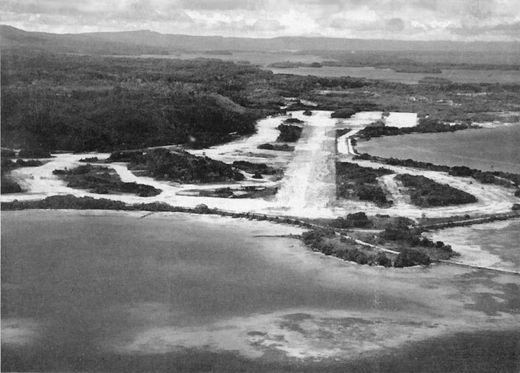 | |
Looking eastward, over Munda Field, toward the scene of battle, this post-war picture shows how the jungle has already begun to encroach on what was the busiest Allied airstrip in the Solomons. Within a year dense vegetation had already obscured Bibilo Hill, while once bare Kokengolo (to the center left of the photograph) sprouts a thick growth. |
A Japanese directive in late October 1942 called for an air base to be built at Munda Point, about 150 miles northwest of Guadalcanal and Henderson Field.
Construction began in mid-November with a great emphasis on keeping the forward airfield secret. The majority of airfield work done before clearing the main runway and surfacing it with crushed coral. By wiring the tops of palm trees to keep them in place, allowing work to initially escape detection. Finally the trunks were cut away, and runway completed.
Despite these efforts, reports of the strip were relayed to Guadalcanal via coastwatcher Danny Kennedy and aerial reconnaissance spotted increased barge traffic and evidence of crushed coral being prepared at the strip, but the Japanese succeeded in buying enough time to complete a single 1094 x 44 yard all weather runway for fighters operational on 17 December 1942.
Opened on 1 December 1942, it was used by the Japanese Navy and Japanese Army Air Force as a forward operating base. As soon as it was operational, the airfield was hampered by the observation of coastwatchers in the area, including Kennedy and D.C. Horton who was observing the airffield from Rendova. It was heavily bombed from the air by the Allies prior to the American landing.
Munda airfield was the principal objective of the Central Solomons campaign, also known as Munda or Munda Point Airfield. It was captured by the US Army XIV Corps forces after 12 continuous days of fierce fighting in the jungle area. The high ground around the airfield fell on August 5, 1943.
Once seized, the Americans improved and expanded the airbase for their own operations. The first American aircraft landed at Munda on August 14, 1943 with landings by F4U Corsairs piloted by Robert Owen of VMF-215, a 44th Fighter Squadron (44th FS) P-40 Warhawk and a J2F Duck with Marine Brigadier General Francis P. Mulcahy aboard.
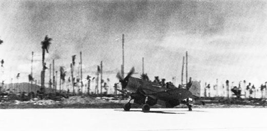 | |
The first fighter plane to land on Munda was a VMF-215 Corsair flown by Maj Robert G. Owens, Jr., on August 14, 1943. |
Known American air units stationed at Munda Airfield were: After the war, the airfield was turned into a commercial airport, used for regional flights by Solomon Airlines.
The above content comes from Wikipedia and is published under free licenses – click here to read more.
| General Info
|
| Country |
Solomon Island
|
| ICAO ID |
AGGM
|
| Time |
UTC+11
|
| Latitude |
-8.327969
08° 19' 40.69" S
|
| Longitude |
157.263092
157° 15' 47.13" E
|
| Elevation |
10 feet
3 meters
|
| Magnetic Variation |
008° E (05/06)
|
| Operating Agency |
CIVIL GOVERNMENT, (LANDING FEES AND DIPLOMATIC CLEARANCE MAY BE REQUIRED)
|
| Island Group |
New Georgia I
|
| Operating Hours |
SUNRISE TO SUNSET (SR-SS)
|
| International Clearance Status |
Airport of Entry
|
| Communications
|
| RDO |
118.1
|
INFO
Mon-Fri 2100-0530Z. OT ctc Honiara AFIS 6553 or 8846 for rdo grd and tfc info.
|
118.1
|
| Runways
|
ID
(Click for details.) |
Dimensions |
Surface |
PCN |
ILS
|
| 07/25 |
4593 x 98 feet
1400 x 30 meters |
ASPHALT |
- |
NO
|
| Supplies/Equipment
|
| Fuel |
Jet A1, without icing nhibitor.
100/130 octane gasoline, leaded, MIL-L-5572F (GREEN)
|
| Remarks
|
| FUEL |
Ltd fuel avbl O/R. (NC-100 - Small stock; A1)
|
| OPR HOURS |
Opr SR-SS.
|
We don't guarantee the information is fresh and accurate. The data may
be wrong or outdated.
For more up-to-date information please refer to other sources.
|
|


