 |
|
Rabaul Airport
Tokua Airport |
| IATA: RAB – ICAO: AYTK
Location of airport in Papua New Guinea
|
| Summary |
| Airport type |
Public |
| Operator |
Government |
| Location |
Rabaul, Papua-New Guinea |
| Elevation AMSL |
32 ft / 10 m |
| Coordinates |
04°20′25″S 152°22′46″E / 4.34028°S 152.37944°E / -4.34028; 152.37944 (Rabaul Airport (new)) |
| Runways |
| Direction |
Length |
Surface |
| ft |
m |
| 10/28 |
5,643 |
1,720 |
Asphalt |
| Source: DAFIF |
Rabaul Airport, also called Tokua Airport, (IATA: RAB, ICAO: AYTK) is an airport serving Kokopo and Rabaul, the current and former capitals of East New Britain Province on New Britain island in Papua New Guinea.
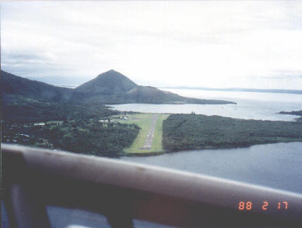 | |
Old Rabaul Airport (17 Feb 1988) |
Prior to the 1994 volcanic eruption that destroyed the town of Rabaul, the airport was located at the foot of Tavurvur volcano, near Matupit island. The airport was destroyed by the eruption, and subsequently the new airport was built and opened at Tokua, on the opposite side of the Rabaul caldera. The former airport was located at 04°13′S 152°11′E / 4.217°S 152.183°E / -4.217; 152.183 (Rabaul Airport (old)).
A volcano eruption closed the airport for a day in 2006. Facilities
The airport resides at an elevation of 32 feet (10 m) above mean sea level. It has one runway designated 10/28 with an asphalt surface measuring 5,643 by 92 feet (1,720 × 28 m).
Airlines and destinations
- Air Niugini (Buka, Hoskins, Kavieng, Port Moresby)
The above content comes from Wikipedia and is published under free licenses – click here to read more.
| General Info
|
| Country |
Papua New Guinea
|
| ICAO ID |
AYTK
|
| Time |
UTC+10
|
| Latitude |
-4.340456
04° 20' 25.64" S
|
| Longitude |
152.379667
152° 22' 46.80" E
|
| Elevation |
32 feet
10 meters
|
| Magnetic Variation |
006° E (01/06)
|
| Beacon |
Yes
|
| Operating Agency |
CIVIL GOVERNMENT, (LANDING FEES AND DIPLOMATIC CLEARANCE MAY BE REQUIRED)
|
| Island Group |
New Britain I
|
| Operating Hours |
24 HOUR OPERATIONS
|
| Communications
|
| TWR |
118.2
|
| MTAF |
120.9
|
| LAE RDO |
127.1
5565
8861
11393
|
| Runways
|
| ID |
Dimensions |
Surface |
PCN |
ILS
|
| 10/28 |
5643 x 92 feet
1720 x 28 meters |
ASPHALT |
020FCYT |
NO
|
| Navaids
|
| Type |
ID |
Name |
Channel |
Freq |
Distance From Field |
Bearing From Navaid
|
| VOR-DME |
TOK |
TOKUA |
083X |
113.6 |
1.1 NM |
282.5
|
| NDB |
TOK |
TOKUA |
- |
227 |
1.1 NM |
285.7
|
| Remarks
|
| CAUTION |
Active volcanoes wi 15 NM of afld. Animal, Bird, pedestrain and vechicle haz. Slope 0.82 dwn to W
|
| FUEL |
Avbl 2000-0800Z dly. (NC-100LL, A1).
|
| LGT |
PCL 124.7Mhz, PAPI MEHT 44'.
|
| RSTD |
Rgt circuits Rwy 28.
|
The content above was published at Airports-Worldwide.com in 2010.
We don't guarantee the information is fresh and accurate. The data may be wrong or outdated.
For more up-to-date information please refer to other sources.
|
|


