 |
 |
|
||||
|
The Wanganui Aero Club has a long history in general aviation and aviation training activity in New Zealand and continues this fine tradition today. The Wanganui Aero Club was one of the first training establishments in New Zealand for training recreational and commercial pilots. The Wanganui Aero Club offers you professional training from ab-initio through to a Commercial Pilots License, Multi Engine Instrument Rating and Instructor Rating.
The aircraft available through the club are a Piper Tomahawk and Cessna 172. As well as a Beech Baron and Pressurized Piper Mojave for Multi Engine and ATPL training. Other aircraft types can also be utilized through our club members Operator: Wanganui District Council Address: PO Box 24 Wanganui New Zealand Phone: (06) 348 9217 Fax: (06) 348 9218 E-mail:
-
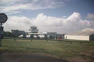
Images and information placed above are from http://www.integration.co.nz/wac/ We thank www.airportsnewzealand.com for the data.
Runway 08/26 2877 x 197 feet
|
||||||||||||||||||||||||||||||||||||||||||||||||||||||||||||||||||||||||||||||||||||||||||||||||||||||||||||||||||||||||||||||||||||||||||||||||||||||||||||||||||||||||||||||||||||||||||||||||||||||||||||||||||||||||||||||||||||||||||||||||||||||||||||||||||||||||||||||||||||||||||||||||||||||||||||||||||||||||||||||||||||||
| Runway 08 | |
|---|---|
| Surface | GRADED OR ROLLED EARTH, GRASS ON GRADED EARTH. |
| True Heading | 106.0 |
| Latitude | 0.000000 - |
| Longitude | 0.000000 - |
| Landing Distance | 2549 feet 777 meters |
| Takeoff Distance | 2877 feet 877 meters |
| Displaced Threshold Length | 328 feet 100 meters |
| Runway 26 | |
|---|---|
| Surface | GRADED OR ROLLED EARTH, GRASS ON GRADED EARTH. |
| True Heading | 286.0 |
| Latitude | 0.000000 - |
| Longitude | 0.000000 - |
| Landing Distance | 2517 feet 767 meters |
| Takeoff Distance | 2877 feet 877 meters |
| Displaced Threshold Length | 360 feet 110 meters |
| Runway 11C | |
|---|---|
| Surface | ASPHALT |
| True Heading | 131.0 |
| Latitude | -39.959642 39° 57' 34.71" S |
| Longitude | 175.017939 175° 01' 04.58" E |
| Elevation | 11.0 feet 3 meters |
| Slope | 0.4° |
| Landing Distance | 4442 feet 1354 meters |
| Takeoff Distance | 4521 feet 1378 meters |
| Displaced Threshold Length | 79 feet 24 meters |
| Lighting System | LIRL
M PAPI |
| Runway 29C | |
|---|---|
| Surface | ASPHALT |
| True Heading | 311.0 |
| Latitude | -39.967139 39° 58' 01.70" S |
| Longitude | 175.031011 175° 01' 51.64" E |
| Elevation | 27.0 feet 8 meters |
| Slope | -0.4° |
| Landing Distance | 4413 feet 1345 meters |
| Takeoff Distance | 4521 feet 1378 meters |
| Displaced Threshold Length | 108 feet 33 meters |
| Lighting System | LIRL
M PAPI |
| Runway 11R | |
|---|---|
| Surface | GRADED OR ROLLED EARTH, GRASS ON GRADED EARTH. |
| True Heading | 128.0 |
| Latitude | 0.000000 - |
| Longitude | 0.000000 - |
| Landing Distance | 2559 feet 780 meters |
| Takeoff Distance | 2756 feet 840 meters |
| Displaced Threshold Length | 197 feet 60 meters |
| Runway 29L | |
|---|---|
| Surface | GRADED OR ROLLED EARTH, GRASS ON GRADED EARTH. |
| True Heading | 308.0 |
| Latitude | 0.000000 - |
| Longitude | 0.000000 - |
| Landing Distance | 2756 feet 840 meters |
| Takeoff Distance | 2756 feet 840 meters |
| Runway 11L | |
|---|---|
| Surface | GRADED OR ROLLED EARTH, GRASS ON GRADED EARTH. |
| True Heading | 128.1 |
| Latitude | 0.000000 - |
| Longitude | 0.000000 - |
| Landing Distance | 1654 feet 504 meters |
| Takeoff Distance | 1654 feet 504 meters |
| Runway 29R | |
|---|---|
| Surface | GRADED OR ROLLED EARTH, GRASS ON GRADED EARTH. |
| True Heading | 308.1 |
| Latitude | 0.000000 - |
| Longitude | 0.000000 - |
| Landing Distance | 1654 feet 504 meters |
| Takeoff Distance | 1654 feet 504 meters |
| Runway 14 | |
|---|---|
| Surface | GRADED OR ROLLED EARTH, GRASS ON GRADED EARTH. |
| True Heading | 161.0 |
| Latitude | 0.000000 - |
| Longitude | 0.000000 - |
| Landing Distance | 2959 feet 902 meters |
| Takeoff Distance | 2959 feet 902 meters |
| Runway 32 | |
|---|---|
| Surface | GRADED OR ROLLED EARTH, GRASS ON GRADED EARTH. |
| True Heading | 341.0 |
| Latitude | 0.000000 - |
| Longitude | 0.000000 - |
| Landing Distance | 2959 feet 902 meters |
| Takeoff Distance | 2959 feet 902 meters |
| WANGANUI | |||||
|---|---|---|---|---|---|
| Type | ID | Channel | Freq | Country | State |
| NDB-DME | WU | 107X | 382 | New Zealand | - |
| Latitude | Longitude | Airport |
| -39.959378 39° 57' 33.76" S |
175.026503 175° 01' 35.41" E |
NZWU |
The content above was published at Airports-Worldwide.com in 2004.
We don't guarantee the information is fresh and accurate. The data may be wrong or outdated.
For more up-to-date information please refer to other sources.

 |
|
Copyright 2004-2026 © by Airports-Worldwide.com, Vyshenskoho st. 36, Lviv 79010, Ukraine Legal Disclaimer |
 The Wanganui Aero Club is situated in the regional City of Wanganui on the West Coast of the North Island of New Zealand. The Club provides various pilot training options including Private Pilot, Commercial and advanced instrument and multi engine training. The Club is located at Wanganui Airport, an uncontrolled airport situated near a large military airport and an international airport. As such it offers an ideal combination of controlled and uncontrolled environments for flying and training.
 By studying with us you will be exposed to a true Multi crew environment that is required of you for an Airline position.