|
|
Sandnessjøen Stokka Airport |
Sandnessjøen Airport, Stokka (Norwegian: Sandnessjøen
Lufthavn, Stokka) (IATA: SSJ, ICAO: ENST)
is a regional airport serving Sandnessjøen in Nordland, Norway. In 2005
Sandnessjøen Airport had 47,514 passengers. It is operated by Avinor.
Service
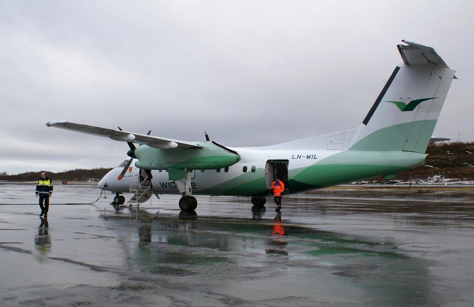
The airport is served by Wideroe with Dash 8 aircraft connecting the
community to Bodo and Trondheim. The routes are operated on public service
obligation with the Norwegian Ministry of Transportation and Communication.
Airlines and destinations
- Wideroe (Bodo, Bronnoysund, Trondheim)
Ground transportation
The airport is located approximately 20 km from town. One bus serves
the airport, but one must call the bus to get a ride, since there is no
scheduled route. The bus can pick you up at any location inside Sandnessjoen.
The phone number is +47 911 64 310. Taxis are also available.
Contact us
Airport service hours
Monday - Friday: 04:50 - 22:30
Saturday: 05:15 - 14:00
Sunday: 11:15 - 23:15
Inquiries about Avinor Sandnessjøen Airport
Phone : (+47) 67 03 33 50
Fax: (+47) 67 03 33 51
Visiting address
Avinor, Sandnessjøen Airport, Stokka, 8800 Sandnessjøen,
Norway
Mailing address
Avinor, Sandnessjøen Airport, Stokka, Postboks 150, 2061 Gardermoen,
Norway
URL:
http://www.avinor.no/en/airport/sandnessjoen
Images and information placed above are from
www.flickr.com
http://www.avinor.no/en/airport/sandnessjoen
http://en.wikipedia.org/wiki/Sandnessjoen_Airport
We thank them for the data!
Text from Wikipedia is available under the Creative
Commons Attribution/Share-Alike License; additional terms may apply.
| General Info
|
| Country |
Norway
|
| ICAO ID |
ENST
|
| Time |
UTC+1(+2DT)
|
| Latitude |
65.956828
65° 57' 24.58" N
|
| Longitude |
12.468944
012° 28' 08.20" E |
| Elevation |
56 feet
17 meters
|
| Type |
Civil
|
| Magnetic Variation |
002° E (01/06) |
| Operating Agency |
CIVIL GOVERNMENT, (LANDING FEES AND
DIPLOMATIC CLEARANCE MAY BE REQUIRED)
|
| Alternate Name |
SANDNESSJOEN STOKKA
|
| Near City |
Sandnessjoen
|
| Operating Hours |
SEE REMARKS FOR OPERATING HOURS OR
COMMUNICATIONS FOR POSSIBLE HOURS
|
| Daylight Saving Time |
Last Sunday in March to last Sunday
in October |
| Communications
|
| GND |
121.9
|
AFIS
Opr 0350-2115Z++ Mon-Fri, 0350-1300Z++ Sat, 1015-2200Z++ Sun.
|
120.3
|
| Runways
|
ID
|
Dimensions |
Surface |
PCN |
ILS
|
| 03/21
|
3563
x 98 feet
1086 x 30 meters |
ASPHALT |
015FCXU |
YES
|
| Navaids
|
| Type |
ID |
Name |
Channel |
Freq |
Distance
From Field |
Bearing
From Navaid
|
| VOR-DME |
STO |
STOKKA |
057X |
112 |
At
Field |
-
|
| Supplies/Equipment
|
| Fuel |
Jet
A1, without icing nhibitor.
100/130 MIL Spec, low lead, aviation gasoline (BLUE)
|
| Other
Fluids |
DE-ICE,
Anti-icing/De-icing/Defrosting Fluid (MIL A 8243) |
| Remarks
|
| CAUTION |
Severe
turb in E to SE wind. Windshear/eddies may occur on short final
Rwy 03 in20+ Kt SE winds and to Rwy 21 in 30+ Kt W-NW winds.
|
| FLUID |
De-Ice-avbl
dur fuel hr.
|
| FUEL |
Avbl
0430-2215Z++ Mon-Fri; 0500-1330Z++ Sat; 0930-1700Z++, 2000-2130Z++
Sun. (NC- A1)
|
| LGT |
ACTIVATE-Apch,
PVASI and strip lgt both rwy, press trans for 5 sec on 120.3. Both
rwy PVASI GS 4.5 , Rwy 21 PVASI area cntr 4 N RCL. |
The content above was published at Airports-Worldwide.com in 2009.
We don't guarantee the information is fresh and accurate. The data may be wrong or outdated.
For more up-to-date information please refer to other sources.
|
|