|
|
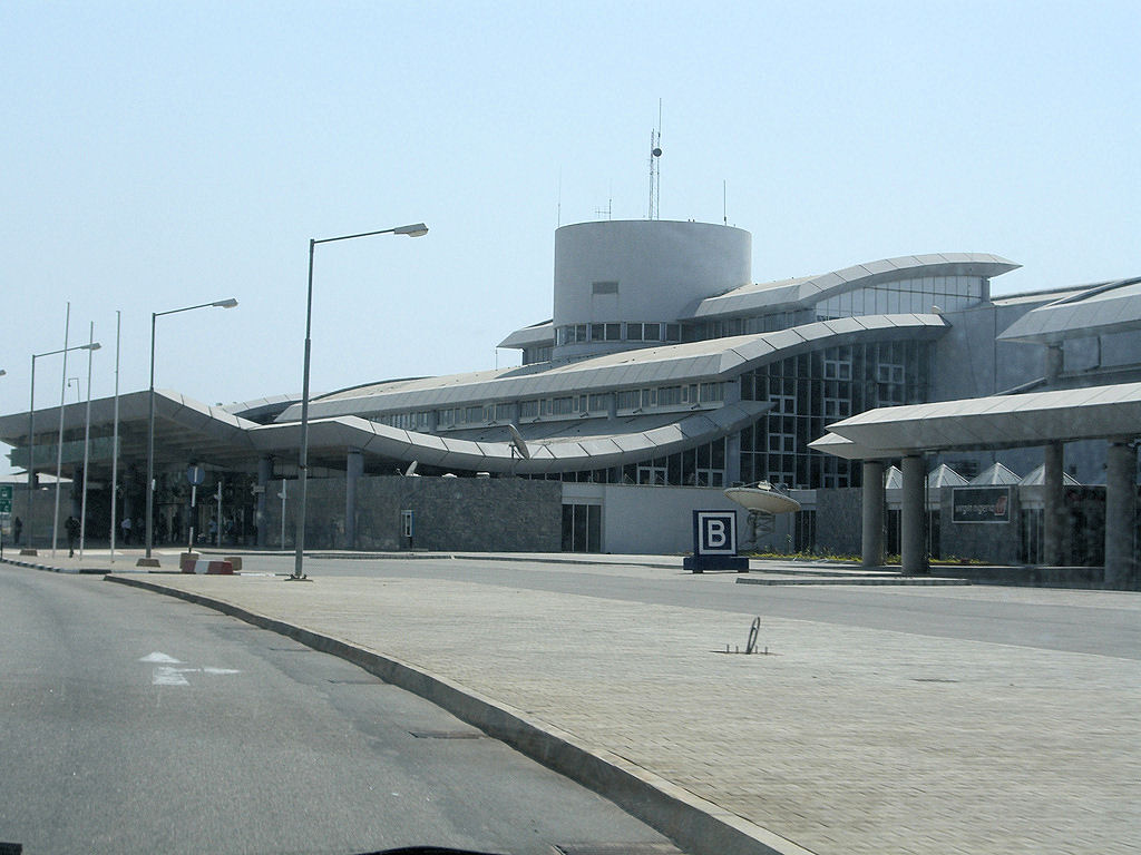
Nnamdi Azikiwe Intl Airport |
Coordinates: 09°00′24″N 007°15′47″E / 9.00667°N 7.26306°E / 9.00667; 7.26306
| Nnamdi Azikiwe International Airport |
 |
| IATA: ABV – ICAO: DNAA |
| Summary |
| Airport type |
Public |
| Owner/Operator |
Federal Airports Authority of Nigeria (FAAN) |
| Serves |
Abuja, Nigeria |
| Elevation AMSL |
1,123 ft / 342 m |
| Runways |
| Direction |
Length |
Surface |
| m |
ft |
| 04/22 |
3,609 |
11,842 |
Asphalt |
| Sources: FAAN and DAFIF |
Nnamdi Azikiwe International Airport (IATA: ABV, ICAO: DNAA) is located in Abuja, FCT, Nigeria, and is the main airport serving the Nigerian capital city. It was named after Nigeria's first President, Dr Nnamdi Azikiwe. It consists of an international and a domestic terminal. Both terminals share the same runway. In 2009, the airport handled 3,196,438 passengers.
The Abuja Gateway Consortium signed on November 13, 2006 an USD101.1 million contract for the management of the airport over the next 25 years. The contract includes the construction of an airport hotel, private car parks, shopping malls and a bonded warehouse, totalling USD50 million, during its first five years in addition to an upfront payment of USD10 million. Total investments will according to the business plan amount to USD371 million during the period of the contract. However, president Yar'Adua revoked the contract on April 2008.
The Nigerian Civil Aviation Authority has its head office on the airport grounds.
Plans call for construction of a second runway. The contract was awarded to Julius Berger for $423 million in April, but were revoked in June due to the high cost. The Federal Government approved fresh bids for construction of the second runway. Statistics
Statistics for Nnamdi Azikiwe International Airport
| Year |
Total Passengers |
% Increase |
Freight (tons) |
Total Aircraft Movements |
| 2002 |
1,441,734 |
-% |
|
|
| 2003 |
1,742,271 |
20.8% |
|
|
| 2004 |
2,194,512 |
26% |
|
|
| 2005 |
2,126,645 |
(3.1%) |
|
|
| 2006 |
2,011,320 |
5.4% |
|
|
| 2007 |
2,190,398 |
8.2% |
|
|
| 2008 |
2,651,282 |
17.4% |
|
|
| 2009 |
3,196,438 |
17.1% |
|
|
Airlines and destinations
| Airlines |
Destinations |
Termintal |
| Aero Contractors (Nigeria) |
Enugu, Lagos, Port Harcourt |
Domestic |
| Air Nigeria |
Lagos, Sokoto |
Domestic |
| Arik Air |
Akure, Benin City, Calabar, Gombe, Enugu, Ilorin, Kano, Katsina, Lagos, Maiduguri, Owerri, Port Harcourt, Sokoto, Uyo, Warri, Yola |
Domestic |
| Arik Air |
London-Heathrow |
International |
| Associated Aviation |
Benin City, Ibadan, Markudi |
Domestic |
| British Airways |
London-Heathrow |
International |
| Delta Air Lines |
New York-JFK |
International |
| Dana Air |
Kano, Lagos |
Domestic |
| EgyptAir |
Cairo |
Inernational |
| Ethiopian Airlines |
Addis Ababa |
International |
| IRS Airlines |
Kano, Lagos, Maiduguri, Yola, Kaduna |
Domestic |
| Kabo Air |
Kano |
Domestic |
| Kabo Air |
Dubai |
International |
| KLM |
Amsterdam |
International |
| Lufthansa |
Frankfurt |
International |
| Overland Airways |
Ibadan, Ilorin, Jos, Katsina, Minna |
Domestic |
Cargo airlines
| Airlines |
Destinations |
| Avient Aviation |
Liège |
| El Al Cargo |
Tel Aviv |
Incidents and accidents
- On 10 December 2005, Sosoliso Airlines Flight 1145 crashed at Port Harcourt Airport in Port Harcourt after flying from Abuja. Of the 105 passengers and 5 crew onboard, only 2 survived.
- On 29 October 2006, ADC Airlines Flight 53 crashed shortly after take-off from Nnamdi Azikiwe International Airport killing 96 onboard and 1 on the ground.
The above content comes from Wikipedia and is published under free licenses – click here to read more.
| General Info
|
| Country |
Nigeria
|
| ICAO ID |
DNAA
|
| Time |
UTC+1
|
| Latitude |
9.006792
09° 00' 24.45" N
|
| Longitude |
7.263172
007° 15' 47.42" E
|
| Elevation |
1123 feet
342 meters
|
| Type |
Civil
|
| Magnetic Variation |
002° W (01/06)
|
| Operating Agency |
CIVIL GOVERNMENT, (LANDING FEES AND DIPLOMATIC CLEARANCE MAY BE REQUIRED)
|
| Alternate Name |
ABUJA
|
| Near City |
Abuja
|
| Operating Hours |
24 HOUR OPERATIONS
|
| International Clearance Status |
Airport of Entry
|
| Communications
|
| TWR |
119.8
|
| ATIS |
123.9
127.5
127.05
|
APP
Opr 0600-1800Z.
|
127.9
119.8
|
| Runways
|
| ID |
Dimensions |
Surface |
PCN |
ILS
|
| 04/22 |
11842 x 197 feet
3609 x 60 meters |
ASPHALT |
- |
YES
|
| Navaids
|
| Type |
ID |
Name |
Channel |
Freq |
Distance From Field |
Bearing From Navaid
|
| VOR-DME |
ABC |
ABUJA |
110X |
116.3 |
2.3 NM |
217.1
|
| NDB |
AG |
ABUJA |
- |
321 |
1.5 NM |
215.0
|
| Supplies/Equipment
|
| Fuel |
Unknown fuel type or whether there is any fuel.
|
| Remarks
|
| FUEL |
A1 (Air Total Int'l)
|
The content above was published at Airports-Worldwide.com in 2010.
We don't guarantee the information is fresh and accurate. The data may be wrong or outdated.
For more up-to-date information please refer to other sources.
|
|