|
|
Deelen Air Base (Dutch: Luchtmachtbasis Deelen or Vliegbasis Deelen) is a military air base in the Netherlands in the province of Gelderland. Though once an active air base, it is now mostly used as a helicopter training site. Being one of the oldest airports in the Netherlands, many buildings on the airfield are now listed as monuments.
| Deelen Air Base |
|
| Map |
|
|
|
|
| Summary |
| Airport type |
Military |
| Operator |
Royal Netherlands Air Force |
| Location |
Deelen |
| Elevation AMSL |
158 ft / 48 m |
| Coordinates |
52°03′33″N
005°52′38″E |
| Runways |
| Direction |
Length |
Surface |
| ft |
m |
| 02/20 |
3,431 |
1,046 |
Concrete/Asphalt |
|
History
|
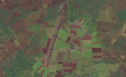
Map of Deelen, the airbase is the area under the red crossmarks. |
Deelen Air Base was founded in 1913 as a base for border patrol missions. When the Netherlands surrendered to Germany in World War II, the Luftwaffe started using the field, significantly expanding and upgrading the base. The Focke-Wulf Fw 190, Messerschmitt Bf 110 and Junkers Ju 88 were operated from the airfield, and anti-aircraft guns were installed. A railway from the nearby town of Wolfheze was constructed, initially to facilitate the transport of building materials for a Luftwaffe command bunker and later to supply the base with munitions. In 1944 in preparation for the Battle of Arnhem the airfield got bombed extensively by allied forces and flying activity from the base was suspended by the Germans. The base was reduced to an auxiliary airfield and turned into a depot for V-1 flying bombs. After the war, up until 1950, the Dutch military used Deelen as a storage facility. In 1950, the decision was made to restore Deelen back to an operational air base, and from 1957 to 1963 was the base for the Royal Netherlands Air Force Republic RF-84F Thunderflash photo reconnaissance aircraft. Between 1964 and 1995 the field was used by various lighter aircraft, such as the de Havilland Canada DHC-2 Beaver, Piper J-3, Hiller OH-23 Raven, Aérospatiale Alouette II / Alouette III and Bölkow 105. In June 1995 Deelen was used for the world premiere of Karlheinz Stockhausen’s Helikopter-Streichquartett.
|
Aérospatiale Alouette III in special markings for the 75th Anniversary of the Royal Netherlands Air Force at Deelen in 1988. |
There was less need for the air base after the end of the cold war and in 1995 it was closed as such. The top layer of the runway was removed making it no longer suitable for landings by heavy aircraft. Its designation was downgraded to Military Aviation Site Deelen (Dutch: Militair Luchtvaart Terrein Deelen). However, it has remained in use as a military site for helicopter training and for that reason is frequently visited by various military helicopters, such as the Boeing AH-64 Apache, Boeing CH-47 Chinook and Eurocopter AS532 Cougar. None of these helicopters are based at Deelen however and for that reason the base is only fully operational when exercises take place. The closure of Soesterberg Air Base resulted in a lot more helicopter movements at Gilze-Rijen Air Base, and in order to reduce traffic there it was decided to use Deelen more often as a training site. To facilitate this it was decided to resurface part of the runway and to create a slope for helicopters to practice sloped landings on. The increased importance of Deelen resulted in it once again receiving the designation of Air Base (Dutch: Vliegbasis).
There is also glider activity on the field and very nearby there is a second aerodrome used almost exclusively by gliders, Terlet Airfield.
The above content comes from Wikipedia and is published under free licenses – click here to read more.
* * *
| General Info
|
| Country |
Netherlands
|
| ICAO ID |
EHDL
|
| Time |
UTC+1(+2DT)
|
| Latitude |
52.060556
52° 03' 38.00" N
|
| Longitude |
5.873056
005° 52' 23.00" E
|
| Elevation |
158 feet
48 meters
|
| Type |
Military
|
| Magnetic Variation |
000° W (01/06)
|
| Operating Agency |
MILITARY
|
| Near City |
Arnhem
|
| Communications
|
TWR
Opr HO
|
122.1
371.475
257.8
|
RAPCON WEST MIL ATCC
Opr HO
|
123.575
375.875
|
| Runways
|
| ID |
Dimensions |
Surface |
PCN |
ILS
|
| 02/20 |
9678 x 164 feet
2950 x 50 meters |
PART CONCRETE, PART ASPHALT, OR PART BITUMEN-BOUND MACADAM. |
- |
NO
|
| Navaids
|
| Type |
ID |
Name |
Channel |
Freq |
Distance From Field |
Bearing From Navaid
|
| TACAN |
DLN |
DEELEN |
059X |
- |
At Field |
-
|
| Remarks
|
| CAUTION |
Gldr/model flying act Sat, Sun and hol SR-SS and O/R.
|
| CSTMS/IMG |
Avbl with 48 hr PN.
|
| RSTD |
Clsd to all acft exc preplanned RNLAF copter.
|
The content above was published at Airports-Worldwide.com in 2018.
We don't guarantee the information is fresh and accurate. The data may be wrong or outdated.
For more up-to-date information please refer to other sources.
|
|