|
|
Coordinates: 28°12′03″N 083°58′55″E / 28.20083°N 83.98194°E / 28.20083; 83.98194
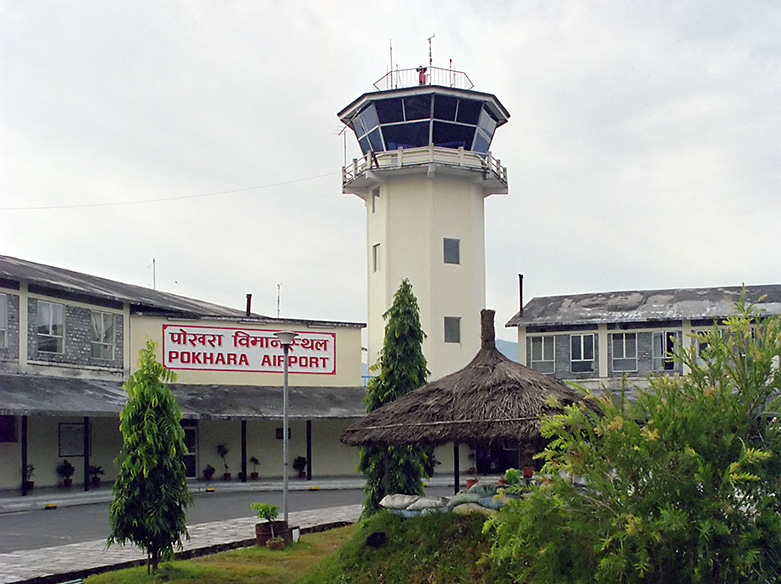
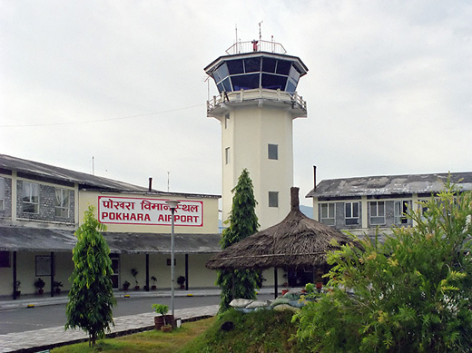
| Pokhara Airport |
 |
| IATA: PKR – ICAO: VNPK |
| Summary |
| Airport type |
Public |
| Operator |
Civil Aviation Authority of Nepal (CAAN) |
| Serves |
Pokhara, Nepal |
| Elevation AMSL |
2,712 ft / 827 m |
| Runways |
| Direction |
Length |
Surface |
| m |
ft |
| 04/22 |
1,433 |
4,701 |
Asphalt |
| Sources: CAAN and DAFIF |
Pokhara Airport (IATA: PKR, ICAO: VNPK), is a regional airport serving Pokhara in Nepal. The airport was established July 4, 1958 and is operated by the government (Civil Aviation Authority of Nepal). It offers regular connections to Kathmandu, Jomsom and seasonal connections to Manang. Airlines and destinations
- Agni Air (Jomsom, Kathmandu)
- Buddha Air (Kathmandu)
- Gorkha Airlines (Jomsom, Kathmandu)
- Nepal Airlines (Jomsom, Kathmandu, Manang)
- Sita Air (Jomsom, Kathmandu)
- Yeti Airlines (Kathmandu)
Incidents and accidents
- 6 November 1997 - A Necon Air Avro 748-100 (9N-ACM), after a flight from Kathmandu, suffered a hydraulic system failure after landing at Pokhara Airport and ran off the runway. The pilot steered the plane back on the runway after 100m, but it ran onto the ramp and struck another Avro 748 (9N-ACW) of Nepal Airlines), which was parked engineless. There were no fatalities among the 44 passengers and 4 crew.
- 22 August 2002 - A Shangri-La Air De Havilland Canada DHC-6 Twin Otter 300, on a flight from Jomsom to Pokhara, crashed into a hill which was under complete cloud cover following 3 days of continuous rain. All 3 crew and 15 passengers were killed.
Terminal
The structural design of the current terminal was designed by Shyam L. Sharma in the early 1990's.
The above content comes from Wikipedia and is published under free licenses – click here to read more.
| General Info
|
| Country |
Nepal
|
| ICAO ID |
VNPK
|
| Time |
UTC+5:45
|
| Latitude |
28.200881
28° 12' 03.17" N
|
| Longitude |
83.982056
083° 58' 55.40" E
|
| Elevation |
2712 feet
827 meters
|
| Magnetic Variation |
000° E (01/06)
|
| Operating Agency |
CIVIL GOVERNMENT, (LANDING FEES AND DIPLOMATIC CLEARANCE MAY BE REQUIRED)
|
| Communications
|
| TWR |
123.8
122.7
|
| Runways
|
| ID |
Dimensions |
Surface |
PCN |
ILS
|
| 04/22 |
4720 x 100 feet
1439 x 30 meters |
ASPHALT |
- |
NO
|
| Navaids
|
| Type |
ID |
Name |
Channel |
Freq |
Distance From Field |
Bearing From Navaid
|
| NDB-DME |
PHR |
POKHARA |
075X |
336 |
At Field |
-
|
| Supplies/Equipment
|
| Fuel |
Jet A1, without icing nhibitor.
|
| Remarks
|
| FUEL |
(NC-A1)
|
| OPR HOURS |
Opr 0100-1215Z Jan-Feb,Nov-Dec; 0030-1245Z Mar-Apr,Sep-Oct; 0015-1300Z May-Aug.
|
The content above was published at Airports-Worldwide.com in 2010.
We don't guarantee the information is fresh and accurate. The data may be wrong or outdated.
For more up-to-date information please refer to other sources.
|
|