 |
|
Sibu Airport
Lapangan Terbang Sibu
诗巫机场 |
 |
| IATA: SBW – ICAO: WBGS |
| Summary |
| Airport type |
Public |
| Owner |
Government of Malaysia |
| Operator |
Malaysia Airports Holdings Berhad |
| Serves |
Bintangor, Sarikei, Kapit, and Sibu, Sarawak, East Malaysia |
| Location |
Sibu, Sarawak, East Malaysia |
| Elevation AMSL |
122 ft / 37 m |
| Coordinates |
02°15′41″N 111°59′07″E / 2.26139°N 111.98528°E / 2.26139; 111.98528 |
| Runways |
| Direction |
Length |
Surface |
| m |
ft |
| 13/31 |
2,754 |
9,036 |
Asphalt |
| Statistics (2008) |
| Passengers |
831,772 |
| Aircraft movements |
14,672 |
| Cargo in tonnes |
735 |
| Sources: official web site and DAFIF |
Sibu Airport (IATA: SBW, ICAO: WBGS) is an airport located in Sibu, a town in the state of Sarawak in Malaysia. In 2008, the airport handled 831,772 passengers on 14,672 flights and also handled 735 metric tonnes of cargo.
In April 2009, the airport was given RM 150 million for an upgrade of the terminal building. Its terminal will be larger than Miri Airport and Bintulu Airport.On September 23 2010,Sarawak Minister of Finance and Public Health Dato Sri Wong Soon Koh had announced that the expansion project is now on.The expansion project,is estimated to be completed in 2012. History
Old Airport
The first airport in Sibu was built in Teku,during World War II by the Japanese as a basic air strip.However,the airstrip was heavily bombed by Allied Forces. After the war, the airport was further developed to house basic airport amenities such as departure lounge and public waiting area. The airport was capable to support Fokker 50 and Twin Otter flights.
On 15 August 1990, a Lockheed C-130H Hercules belonging to the Malaysian Royal Air Force skidded off the runway and the aircraft had been written off. It was believed that those on board are part of the royal entourage visit to Sibu.
On 2 September 1992, a Fokker 50 aircraft landing gear failed, causing the aircraft to veered off the runway and into the bushes.
The old airport has been demolished to make way for Laila Taib College (formerly known as UCS-United College of Sarawak) & Tun Zaidi Stadium. The runway of the old airport can still be seen and half of it is used as the connecting road for the stadium.
New Airport
The actual official date of operation of the new airport began 1 June 1994. On 31 May 1994 the inaugural landing of four Malaysia Airlines aircraft occurred. To be precise, the aircraft were 3 Fokker 50 and 1 Boeing 737. They were the pioneers to land on the Sibu New Airport Runway which at that time measured 1,981 metres in length and 45 metres wide.
On that remarkably historical night, the air traffic clearance “Clear to land” was issued from the Sibu Air Traffic Control Tower on the assigned frequency 122.6 MHZ to the first Boeing 737-500 to land on the asphalt surface of the designated Runway 13.
That night not only marked the first landing of a turbo-prop commercial aircraft on Sibu ground but subsequently it also commemorated the commencement of operation of the new airport located 23 kilometres East South-East of Sibu town.
Sibu New Airport was built with a single runway designated as Runway 13/Runway 31. It was previously 1,981 metres long and 45 metres wide but since the completion of the extension under the 7th Malaysian Plan (RMK7) for ‘Sibu Airport Development Plan’, the length was extended to 2,745 metres. And the new runway length was commissioned to be used on the 9 May 2006. The extended length is able to cater the landing of an Airbus A330 or other wide bodied jet aircraft.
Runway 13 is equipped with an approach lighting system called Precision Approach Lighting Category 1, whereas Runway 31 with Simple Approach Lighting System. The other airside areas such as the taxiways (‘A’ and ‘B’) and apron are also furnished with appropriate lighting aids. The maximum capacity of the parking apron is one Airbus, two Boeing 737-400s, two Fokker 50 and two Twin Otter or similar aircraft. Only bay 2 and 3 are equipped with aerobridges functioning on Visual Docking and Guidance System. The functional Runway is also equipped with landing aids such as the Middle Marker (MM), Glide Path (GP), the Localizer (LLZ) and the PAPI. All the stated instruments are installed to be utilized by aircraft to assist them during the final approach process and landing manoeuvres.
Source: [1]
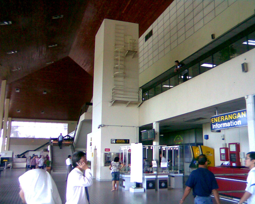
Airlines and destinations
Passenger terminals
Airlines operating in Sibu Airport
| Airlines |
Destinations |
| AirAsia |
Domestic: Johor Bahru, Kuala Lumpur, Kuching |
| Malaysia Airlines
|
Domestic: Kuala Lumpur, Kuching
- Domestic: Bintulu, Kota Kinabalu, Kuching, Miri,Limbang (via Miri)
|
Traffic and statistics
Overall Operational Statistics
| Years |
Passenger Movements |
Aircraft Movements |
Cargo Movements in Metric Tonnes |
| 1995 |
624,738 |
18,905 |
2,455 |
| 1996 |
654,785▲4.81% |
20,243 ▲7.08% |
1,758▼28.39% |
| 1997 |
631,701▼3.53% |
19,551 ▼3.42% |
1,904▲8.3% |
| 1998 |
555,483▼12.07% |
17,099 ▼12.54% |
1,499▼21.27% |
| 1999 |
620,830▲11.76% |
16,096 ▼5.87% |
1,745▲16.41% |
| 2000 |
657,375▲5.89% |
15,743 ▼2.19% |
1,874▲7.39% |
| 2001 |
725,449▲10.36% |
16,995 ▲7.95% |
2,006▲7.04% |
| 2002 |
759,704▲4.72% |
17,113 ▲0.69% |
1,916▼4.49% |
| 2003 |
817,687 ▲7.63% |
16,885 ▼1.33% |
1,701▼11.22% |
| 2004 |
903,108 ▲10.45% |
17,650 ▲4.53% |
1,567▼7.88% |
| 2005 |
920,930 ▲1.97% |
17,330 ▼1.81% |
1,377▼12.13% |
| 2006 |
898,923▼2.39% |
15,638 ▼9.76% |
1,040▼24.47% |
| 2007 |
809,955▼9.9% |
12,536 ▼19.84% |
892▼14.23% |
| 2008 |
831,772▲2.7% |
14,672 ▲17.00% |
735▼17.50% |
Busiest Domestic Flights of Sibu Airport by Frequency
| Rank |
Destinations |
Departure (Weekly) |
Arrival (Weekly) |
| 1 |
Kuching |
56 |
49 |
| 2 |
Kuala Lumpur |
28 |
28 |
| 3 |
Kota Kinabalu |
21 |
28 |
| 4 |
Miri |
21 |
21 |
| 5 |
Bintulu |
14 |
14 |
| 6 |
Johor Bahru |
4 |
4 |
The above content comes from Wikipedia and is published under free licenses – click here to read more.
| General Info
|
| Country |
Malaysia
|
| ICAO ID |
WBGS
|
| Time |
UTC+8
|
| Latitude |
2.261603
02° 15' 41.77" N
|
| Longitude |
111.985322
111° 59' 07.16" E
|
| Elevation |
122 feet
37 meters
|
| Type |
Civil
|
| Magnetic Variation |
000° E (01/06)
|
| Beacon |
Yes
|
| Operating Agency |
CIVIL GOVERNMENT, (LANDING FEES AND DIPLOMATIC CLEARANCE MAY BE REQUIRED)
|
| Operating Hours |
SEE REMARKS FOR OPERATING HOURS OR COMMUNICATIONS FOR POSSIBLE HOURS
|
| Communications
|
| TWR |
122.6
123.2
|
| GND |
121.9
|
| ATIS |
127.65
|
| APP |
122.6
123.2
|
| Runways
|
| ID |
Dimensions |
Surface |
PCN |
ILS
|
| 13/31 |
9036 x 148 feet
2754 x 45 meters |
ASPHALT |
032FBXT |
YES
|
| Navaids
|
| Type |
ID |
Name |
Channel |
Freq |
Distance From Field |
Bearing From Navaid
|
| VOR-DME |
VSI |
SIBU |
059X |
112.2 |
1.4 NM |
308.4
|
| NDB |
NIS |
SIBU |
- |
203 |
1.3 NM |
308.3
|
| Remarks
|
| CAUTION |
441' hill on final Rwy 31 427' fr thld. Pilots ldg use extreme caution.
|
| CSTMS/IMG |
Avbl.
|
| FUEL |
(NC-100, A1)
|
| OPR HOURS |
Opr 2230-1300Z, OT PPR fr KINABALU FIC before 0800Z.
|
| RSTD |
All acft to avoid flying at 500' or below over the ammunition depot 1.7NM fr Thld Rwy 13.
|
The content above was published at Airports-Worldwide.com in 2010.
We don't guarantee the information is fresh and accurate. The data may be wrong or outdated.
For more up-to-date information please refer to other sources.
|
|


