 |
|
| Osh Airport |
 |
| IATA: OSS – ICAO: UAFO |
| Summary |
| Airport type |
Public |
| Operator |
Government |
| Serves |
Osh, Kyrgyzstan |
| Elevation AMSL |
2,927 ft / 892 m |
| Coordinates |
40°36′32″N 072°47′35″E / 40.60889°N 72.79306°E / 40.60889; 72.79306 |
| Runways |
| Direction |
Length |
Surface |
| m |
ft |
| 12/30 |
2,614 |
8,576 |
Asphalt |
| Source: DAFIF |
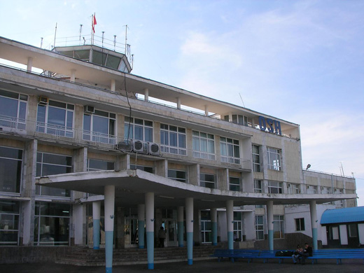
Marshrutka outside terminal Osh Airport (IATA: OSS, ICAO: UAFO) is an airport serving Osh, a city in the Osh province (oblast) of Kyrgyzstan.
International arrivals with questions concerning their entry into the country may call the border service's Southern Regional Administration at (0 3222) 7-25-25; 2-34-6 or border unit #2011 at (0 3222) 5-55-09; 3-89-38. Airlines and destinations
| Airlines |
Destinations |
| Avia Traffic Company |
Bishkek |
| China Southern Airlines |
Urumqi |
| Eastok Avia |
Bishkek |
| Itek Air |
Moscow-Domodedovo, Novosibirsk |
| Kyrgyzstan |
Bishkek, Moscow-Domodedovo |
| Kyrgyzstan Airlines |
Bishkek, Karavan |
| Osh-Avia |
Bishkek |
| S7 Airlines |
Moscow-Domodedovo |
| VIM Airlines |
Moscow-Domodedovo |
Ground transportation
Marshrutka route #107 serves the airport.
The above content comes from Wikipedia and is published under free licenses – click here to read more.
| General Info
|
| Country |
Kyrgyzstan
|
| ICAO ID |
UAFO
|
| Time |
UTC+5(+6DT)
|
| Latitude |
40.608989
40° 36' 32.36" N
|
| Longitude |
72.793269
072° 47' 35.77" E
|
| Elevation |
2927 feet
892 meters
|
| Type |
Civil
|
| Magnetic Variation |
004° E (01/06)
|
| Operating Agency |
CIVIL GOVERNMENT, (LANDING FEES AND DIPLOMATIC CLEARANCE MAY BE REQUIRED)
|
| Operating Hours |
24 HOUR OPERATIONS
|
| Daylight Saving Time |
1 April to 30 September
|
| Communications
|
TWR
Opr HO. Call Start.
|
118.3
|
METEO
Opr HO
|
134.2
|
GND
Opr HO. Call Taxiing.
|
121.8
|
GCA
Opr HO. Call Krug.
|
120.6
|
APP
Opr HO.
|
124.2
|
| Communications Remarks |
|
| APP |
(R)
|
| Runways
|
| ID |
Dimensions |
Surface |
PCN |
ILS
|
| 12/30 |
8576 x 164 feet
2614 x 50 meters |
ASPHALT |
032FCXT |
YES
|
| Navaids
|
| Type |
ID |
Name |
Channel |
Freq |
Distance From Field |
Bearing From Navaid
|
| NDB |
OU |
OSH |
- |
780 |
2.8 NM |
126.0
|
| Supplies/Equipment
|
| Fuel |
Jet A, without icing inhibitor.
|
| Remarks
|
| CAUTION |
Rwy 12/30 clsd 0500-1240 til 31 Dec 05 est.
|
| FUEL |
(NC-TS-1)
|
| OIL |
O-MK8P
|
| RSTD |
The first (100m) 328' of Rwy 12-30 unusable for tkof.
|
The content above was published at Airports-Worldwide.com in 2020.
We don't guarantee the information is fresh and accurate. The data may be wrong or outdated.
For more up-to-date information please refer to other sources.
|
|

![Kyrgyz
Kyrgyzstani[2] airports - Osh Airport](../img/air-fly-D2.gif)


