 |
 |
|
||||
|
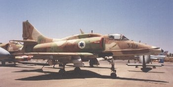
Nevatim Airbase An international airport at the Nevatim airbase should be developed. The Nevatim airfield is situated on a military base 20 minutes east of Beer-Sheva. Israel currently has only one international airport, Ben-Gurion Airport at Lod whose capacity no longer suits the growing needs. Expansion work done at Ben-Gurion Airport began in 1998 and should be completed no earlier than the end of 2003. This expansion was delayed for many years due to the objection of the nearby settlements. The Nevatim airfield has three major advantages: 1. A business inclination – The Negev’s authorities are very
interested in promoting an international airport in Nevatim. Images and information placed above are from
Runway 08C/26C10991 x 147 feet
|
|||||||||||||||||||||||||||||||||||||||||||||||||||||||||||||||||||||||||||||||||||||||||||||||||||||||||||||||||||||||||||||||||||||||||||||||||||||||||||||||||||||||||||||||||||||||||||||||||||||||||||||||||||||||||||||||||||||||||||||||||
| Runway 08C | |
|---|---|
| Surface | ASPHALT |
| True Heading | 077.0 |
| Latitude | 31.204417 31° 12' 15.90" N |
| Longitude | 34.995056 034° 59' 42.20" E |
| Elevation | 1295.0 feet 395 meters |
| Slope | 0.6° |
| Landing Distance | 10991 feet 3350 meters |
| Takeoff Distance | 11483 feet 3500 meters |
| Overrun Length | 492 feet 150 meters |
| Overrun Surface | ASPHALT |
| Lighting System | CL
LIRL A |
| Runway 26C | |
|---|---|
| Surface | ASPHALT |
| True Heading | 257.0 |
| Latitude | 31.211306 31° 12' 40.70" N |
| Longitude | 35.029278 035° 01' 45.40" E |
| Elevation | 1360.0 feet 415 meters |
| Slope | -0.6° |
| Landing Distance | 10991 feet 3350 meters |
| Takeoff Distance | 11838 feet 3608 meters |
| Overrun Length | 847 feet 258 meters |
| Overrun Surface | ASPHALT |
| Lighting System | CL
LIRL A |
| Runway 08R | |
|---|---|
| Surface | ASPHALT |
| True Heading | 077.1 |
| Latitude | 31.200000 31° 12' 00.00" N |
| Longitude | 34.996333 034° 59' 46.80" E |
| Landing Distance | 8395 feet 2559 meters |
| Takeoff Distance | 8395 feet 2559 meters |
| Runway 26L | |
|---|---|
| Surface | ASPHALT |
| True Heading | 257.1 |
| Latitude | 31.205167 31° 12' 18.60" N |
| Longitude | 35.022500 035° 01' 21.00" E |
| Landing Distance | 8395 feet 2559 meters |
| Takeoff Distance | 8395 feet 2559 meters |
| Runway 08L | |
|---|---|
| Surface | ASPHALT |
| True Heading | 077.0 |
| Latitude | 31.207472 31° 12' 26.90" N |
| Longitude | 34.994222 034° 59' 39.20" E |
| Elevation | 1290.0 feet 393 meters |
| Slope | 0.4° |
| Landing Distance | 8530 feet 2600 meters |
| Takeoff Distance | 9022 feet 2750 meters |
| Overrun Length | 492 feet 150 meters |
| Overrun Surface | ASPHALT |
| Lighting System | CL
LIRL A V |
| Runway 26R | |
|---|---|
| Surface | ASPHALT |
| True Heading | 257.0 |
| Latitude | 31.212833 31° 12' 46.20" N |
| Longitude | 35.020778 035° 01' 14.80" E |
| Elevation | 1320.0 feet 402 meters |
| Slope | -0.4° |
| Landing Distance | 8530 feet 2600 meters |
| Takeoff Distance | 9022 feet 2750 meters |
| Overrun Length | 492 feet 150 meters |
| Overrun Surface | ASPHALT |
| Lighting System | CL
LIRL A V |
| Runway 15 | |
|---|---|
| Surface | ASPHALT |
| True Heading | 146.9 |
| Latitude | 31.207889 31° 12' 28.40" N |
| Longitude | 35.031528 035° 01' 53.50" E |
| Landing Distance | 2806 feet 855 meters |
| Takeoff Distance | 2806 feet 855 meters |
| Runway 33 | |
|---|---|
| Surface | ASPHALT |
| True Heading | 326.9 |
| Latitude | 31.201417 31° 12' 05.10" N |
| Longitude | 35.036444 035° 02' 11.20" E |
| Landing Distance | 2806 feet 855 meters |
| Takeoff Distance | 2806 feet 855 meters |
The content above was published at Airports-Worldwide.com in 2005.
We don't guarantee the information is fresh and accurate. The data may be wrong or outdated.
For more up-to-date information please refer to other sources.

 |
|
Copyright 2004-2024 © by Airports-Worldwide.com, Vyshenskoho st. 36, Lviv 79010, Ukraine Legal Disclaimer |
 Nevatim
AB (LLNV) located between Arad and Beer-Sheeba, Israel.
Nevatim
AB (LLNV) located between Arad and Beer-Sheeba, Israel.