 |
 |
|
||||
|
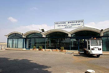
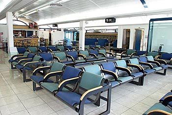
The airfield at Mahanaim, east of Rosh Pina, was constructed by the British Mandate administration in the years 1943-1945, during the time of King George VI of Britain. The airfield served the British as a forward airfield, serving the needs of the British Military, against the French army operating in Syria. Two intersecting runways were constructed for this purpose: 05 - 23 and 15 - 33 of a length of 1,080 meters and a width of 40 meters, surrounded by peripheral taxiways, in accordance with the British Standard. The paving method was rather interesting: Compressed aggregate for the covering of the runways, a layer of bitumen and on that an additional layer of gravel and asphalt. Since 1948 - with the establishment of the State, the airfield was taken over by the Air Force. Battle positions and cover from the time of the British Mandate remained at the airfield, but the control tower and passenger terminal were not yet erected. In the 1950s, Arkia began commercial activities at Rosh Pina, working from a hut, which served as the passenger terminal as well as the control tower. 1968 - The activities are transferred to the end of Runway 33, where a passenger Terminal was built. 1971 - A control tower and fire station are constructed at the airfield. The fire station is equipped with modern fire engines, replacing the firefighting services which were provided until that time by the Hatzor Haglilit Town Federation. 1994 - The Passenger Terminal is renovated and extended, in the wake
of the increase in passenger traffic and the activities of Arkia. Country Code: +972 ~ IDD Access Code: 00 ~ Domestic Prefix: 0 ~ Time Zone: GMT+2 Rosh Pina - Mahanaim Ben Yaakov Airport (RPN/LLIB) Airport Data: Position 32°58´52"N, 035°34´19"E, Elevation 281m (921ft) Airfield Data Address: Rosh Pina Airport, Tel: +972 (0)6 936478 WEB: http://www.iaa gov il/Rashat/en-US/Airports/RoshPina/ E-mail: telmas at iaa gov il Images and information placed above are from
Runway 05/233190 x 100 feet
|
|||||||||||||||||||||||||||||||||||||||||||||||||||||||||||||||||||||||||||||||||||||||||||||||||||||||||||||||||||||||||||||||||||||||||||||||||||||||||||||||||||||||||||||||||||||||||||||||||||||||||||||||||||||||||||||||||||||||||||||||||||||
| Runway 05 | |
|---|---|
| Surface | ASPHALT |
| True Heading | 054.1 |
| Latitude | 32.977742 32° 58' 39.87" N |
| Longitude | 35.566036 035° 33' 57.73" E |
| Landing Distance | 3190 feet 972 meters |
| Takeoff Distance | 3310 feet 1009 meters |
| Overrun Length | 120 feet 37 meters |
| Overrun Surface | ASPHALT |
| Runway 23 | |
|---|---|
| Surface | ASPHALT |
| True Heading | 234.1 |
| Latitude | 32.982883 32° 58' 58.38" N |
| Longitude | 35.574464 035° 34' 28.07" E |
| Landing Distance | 3190 feet 972 meters |
| Takeoff Distance | 3400 feet 1036 meters |
| Overrun Length | 210 feet 64 meters |
| Overrun Surface | ASPHALT |
| Runway 15 | |
|---|---|
| Surface | ASPHALT |
| True Heading | 151.0 |
| Latitude | 32.987161 32° 59' 13.78" N |
| Longitude | 35.568119 035° 34' 05.23" E |
| Landing Distance | 3565 feet 1087 meters |
| Takeoff Distance | 3655 feet 1114 meters |
| Displaced Threshold Length | 90 feet 27 meters |
| Lighting System | LIRL
V |
| Runway 33 | |
|---|---|
| Surface | ASPHALT |
| True Heading | 331.0 |
| Latitude | 32.978425 32° 58' 42.33" N |
| Longitude | 35.573989 035° 34' 26.36" E |
| Landing Distance | 3335 feet 1017 meters |
| Takeoff Distance | 3655 feet 1114 meters |
| Displaced Threshold Length | 320 feet 98 meters |
| Lighting System | LIRL
V |
| ROSH PINA | |||||
|---|---|---|---|---|---|
| Type | ID | Channel | Freq | Country | State |
| VOR-DME | ROP | 100X | 115.3 | Israel | - |
| Latitude | Longitude | Airport |
| 32.982572 32° 58' 57.26" N |
35.572744 035° 34' 21.88" E |
LLIB |
| ROSH PINA | |||||
|---|---|---|---|---|---|
| Type | ID | Channel | Freq | Country | State |
| NDB | RPN | - | 243 | Israel | - |
| Latitude | Longitude | Airport |
| 32.966944 32° 58' 01.00" N |
35.556667 035° 33' 24.00" E |
LLIB |
The content above was published at Airports-Worldwide.com in 2005.
We don't guarantee the information is fresh and accurate. The data may be wrong or outdated.
For more up-to-date information please refer to other sources.

 |
|
Copyright 2004-2026 © by Airports-Worldwide.com, Vyshenskoho st. 36, Lviv 79010, Ukraine Legal Disclaimer |
 History:
 Information: