 |
 |
|
||||
|
The development impetus of Eilat at the outset of the 1950s, and the distance of the settlement from the center of the country, brought about the development of a regular air service from Lod Airport (BGA of today) and later from Haifa. All the regular flights were undertaken by Arkia, and prior to that by Ilta, a subsidiary of El Al, and by Aviron. In 1964, the runway was extended to 1,500 meters, and a small passenger terminal was built. In 1969, the runway was extended to its current length of 1,900 meters.
In 1975, the first charter flight, by Sterling Airways of Denmark, landed in Eilat, and since then international charter flights have been landing regularly at the Airport. From the mid-80s, El Al also began operating regular flights to Europe. In 1990 – 1991, due to the Gulf War, the charter flight season was curtailed, which affected the international flights to Eilat. Eilat Airport today serves internal civilian flights, international charter flights, private flights and special flights. Country Code: +972 ~ IDD Access Code: 00 ~ Domestic Prefix: 0 ~ Time
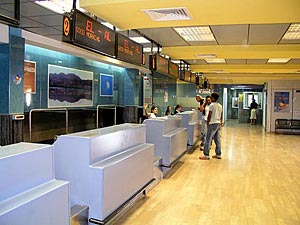
Zone: GMT+2 SITA: ETHELXH Airfield Data: Fire Category 6 Airlines Serving Airport: Arkia, El Al, Israir Customs Tel: +972 (0)8 637 5387Fax: +972 (0)8 631 5911 Passenger Facilities: 12 check-in desks, 4 gates, 2 baggage claim belts, short term parking spaces Additional Information: Recent addition of the elevators for disabled
access in the departures and in the arrival halls. Address: Eilat Airport, Israel, Tel: (Co-ordination Dir) +972 (0)8 636 3805, e-mail: teum_eilat at iaa.co.il WEB: http://www.iaa gov il/Rashat/en-US/Airports/Eilat/ Images and information placed above are from
Runway 03/216234 x 89 feet
|
||||||||||||||||||||||||||||||||||||||||||||||||||||||||||||||||||||||||||||||||||||||||||||||||||||||||||||||||||||||||||||||||||||||||||||||||||||||||||||||||||||||||||||||||||||||||||
| Runway 03 | |
|---|---|
| Surface | ASPHALT |
| True Heading | 028.0 |
| Latitude | 29.553703 29° 33' 13.33" N |
| Longitude | 34.955500 034° 57' 19.80" E |
| Elevation | 16.0 feet 5 meters |
| Slope | 0.4° |
| Landing Distance | 5289 feet 1612 meters |
| Takeoff Distance | 6234 feet 1900 meters |
| Displaced Threshold Length | 945 feet 288 meters |
| Lighting System | HIRL
PAPI |
| Runway 21 | |
|---|---|
| Surface | ASPHALT |
| True Heading | 208.0 |
| Latitude | 29.568833 29° 34' 07.80" N |
| Longitude | 34.964722 034° 57' 53.00" E |
| Elevation | 41.5 feet 13 meters |
| Slope | -0.4° |
| Landing Distance | 6234 feet 1900 meters |
| Takeoff Distance | 6359 feet 1938 meters |
| Overrun Length | 125 feet 38 meters |
| Overrun Surface | ASPHALT |
| Lighting System | HIRL
PAPI |
| EILOT | |||||
|---|---|---|---|---|---|
| Type | ID | Channel | Freq | Country | State |
| VOR-DME | LOT | 057X | 112 | Israel | - |
| Latitude | Longitude | Airport |
| 29.607778 29° 36' 28.00" N |
34.975556 034° 58' 32.00" E |
LLET |
The content above was published at Airports-Worldwide.com in 2005.
We don't guarantee the information is fresh and accurate. The data may be wrong or outdated.
For more up-to-date information please refer to other sources.

 |
|
Copyright 2004-2026 © by Airports-Worldwide.com, Vyshenskoho st. 36, Lviv 79010, Ukraine Legal Disclaimer |
 History:
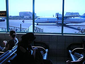 Information: