 |
|
Coordinates: 00°47′12″S 100°16′50″E / 0.78667°S 100.28056°E / -0.78667; 100.28056
Minangkabau Airport
Bandar Udara Minangkabau |
 |
| IATA: PDG – ICAO: WIPT |
| Summary |
| Airport type |
Public |
| Operator |
PT Angkasa Pura II |
| Serves |
Padang, West Sumatra, Indonesia |
| Location |
Ketaping, Padang Pariaman |
| Elevation AMSL |
18 ft / 5 m |
| Website |
MinangkabauAirport.com |
| Runways |
| Direction |
Length |
Surface |
| m |
ft |
| 15/33 |
2,749 |
9,020 |
Asphalt |
| Source: DAFIF |
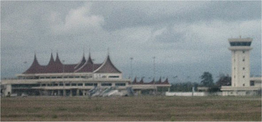
Minangkabau International Airport (IATA: PDG, ICAO: WIPT) is the principal airport serving the province of West Sumatra on the island of Sumatra, Indonesia. It is located about 23 km north-west of Padang, in Ketaping, Padang Pariaman regency. There is one terminal building for both international flights and domestic flights. The airport has 17 check-in counters, 5 baggage conveyors, and 9 ticket sales counters.
The land area of the airport is 4.27 km². It has one runway:
- R/W Heading 15/33 : 2,750 m x 45 m
There is a plan to lengthen the runway by 250 m to be compatible with Boeing 747 planes, and also to connect the airport to the city of Padang with a train service.
The terminal expansion (Phase II) is already announced and the rendering is already released in Angkasa Pura 2 website.
The airport became operational in July 2005, replacing the old Tabing Airport in Padang. The airport is named after the Minangkabau ethnic group who inhabit the region.
The airport suffered minor damage in an earthquake in September, 2009.
Airlines and destinations
The following destinations are served from the airport (as of June 2008):
| Airlines |
Destinations |
| Air Asia |
Kuala Lumpur |
| Batavia Air |
Jakarta-Soekarno Hatta |
| Firefly |
Subang |
| Garuda Indonesia |
Jakarta-Soekarno Hatta |
| Lion Air |
Jakarta-Soekarno Hatta |
| Kartika Airlines |
Batam, Jakarta-Soekarno Hatta, Medan |
| Mandala Airlines |
Batam, Jakarta-Soekarno Hatta, Madan |
| Merpati Nusantara Airlines |
Bandung, Batam |
| Sriwijaya Air |
Jakarta-Soekarno Hatta, Medan |
The above content comes from Wikipedia and is published under free licenses – click here to read more.
| General Info
|
| Country |
Indonesia
|
| ICAO ID |
WIPT
|
| Time |
UTC+7
|
| Latitude |
-0.786917
00° 47' 12.90" S
|
| Longitude |
100.280797
100° 16' 50.87" E
|
| Elevation |
18 feet
5 meters
|
| Type |
Civil
|
| Magnetic Variation |
000° W (01/06)
|
| Beacon |
Yes
|
| Operating Agency |
CIVIL GOVERNMENT, (LANDING FEES AND DIPLOMATIC CLEARANCE MAY BE REQUIRED)
|
| Near City |
Padang
|
| Island Group |
Sumatra I
|
| Operating Hours |
SEE REMARKS FOR OPERATING HOURS OR COMMUNICATIONS FOR POSSIBLE HOURS
|
| International Clearance Status |
Airport of Entry
|
| Communications
|
| MINANG TWR |
118.3
|
| ATIS |
127.25
|
| PADANG APP |
120.4
|
| Runways
|
| ID |
Dimensions |
Surface |
PCN |
ILS
|
| 15/33 |
9020 x 148 feet
2749 x 45 meters |
ASPHALT |
083FCXT |
YES
|
| Navaids
|
| Type |
ID |
Name |
Channel |
Freq |
Distance From Field |
Bearing From Navaid
|
| VOR-DME |
MKB |
MINANGKABAU |
094X |
114.7 |
At Field |
-
|
| Supplies/Equipment
|
| Fuel |
Jet A1, without icing nhibitor.
100/130 MIL Spec, low lead, aviation gasoline (BLUE)
|
| Remarks
|
| FUEL |
(NC A1, 100LL)
|
| MISC |
Opr fone C0751-483672 extn 75.
|
| OPR HOURS |
Opr 0000-1400Z.
|
The content above was published at Airports-Worldwide.com in 2010.
We don't guarantee the information is fresh and accurate. The data may be wrong or outdated.
For more up-to-date information please refer to other sources.
|
|


