|
|
Coordinates: 01°11′24″S 136°06′29″E / 1.19°S 136.10806°E / -1.19; 136.10806
Frans Kaisiepo Airport
Bandara Frans Kaisiepo |
| IATA: BIK – ICAO: WABB |
| Summary |
| Airport type |
Public |
| Operator |
PT Angkasa Pura I |
| Location |
Biak, Papua |
| Elevation AMSL |
46 ft / 14 m |
| Runways |
| Direction |
Length |
Surface |
| ft |
m |
| 11/29 |
11,715 |
3,571 |
Asphalt |
| Source: World Aero Data |
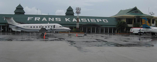 | |
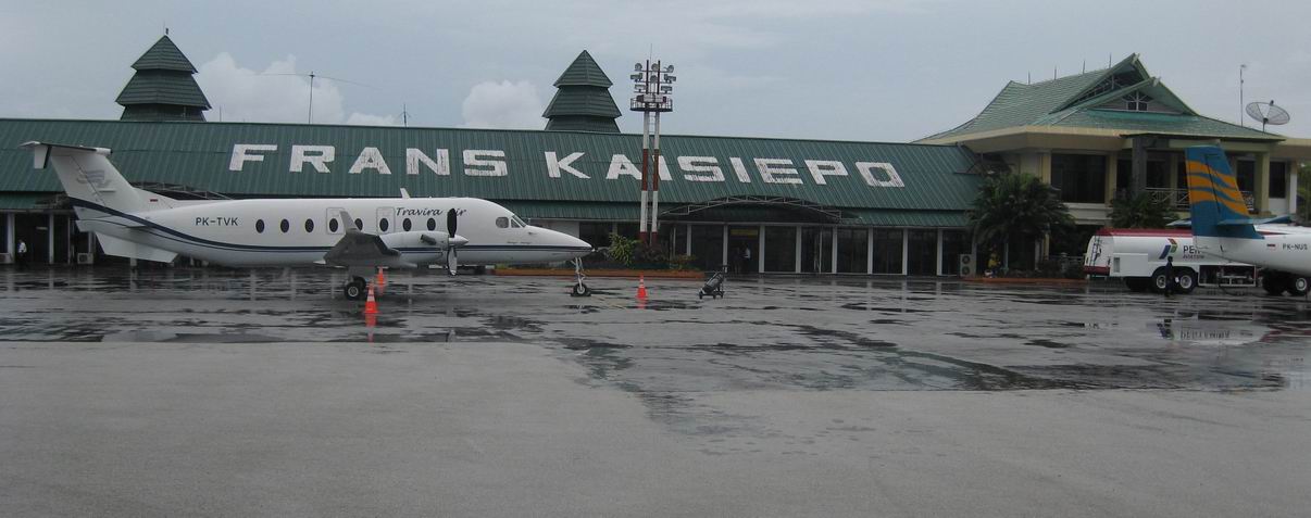
Frans Kaisiepo Airport of Biak |
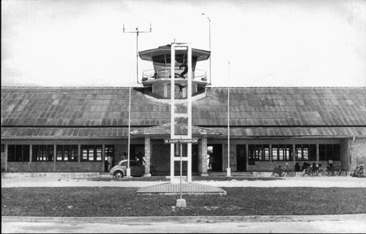 | |
Mokmer Airport in 1961 |
Frans Kaisiepo Airport (Indonesian: Bandara Frans Kaisiepo) (IATA: BIK, ICAO: WABB) is an airport in Biak, Papua, Indonesia. It is also known as Mokmer Airport. This airport is named after Frans Kaisiepo, the fourth Governor of Papua. Airlines and destinations
| Airlines |
Destinations |
| Garuda Indonesia |
Jayapura, Ujungpandang |
| Interisland Airlines |
Vigan |
| Merpati Nusantara Airlines |
Jayapura, Ujungpandang |
| Susi Air |
Nabire, Serui |
History
Mokmer Airfield was part of a complex of airfields built on Biak Island by the Japanese (Mokmer, Borokoe and Sorido), of which Mokmer was the main USAAF facility after the island was taken by the United States after fierce fighting in late May and June 1944.
The Battle of Biak Island came about after a succession of Japanese defeats in 1943 and 1944 along the northern coast of New Guinea. Biak became a Japanese stronghold, which they were determined to hold to the last man. Unknown to the advancing Allies, the Japanese began fortifying the island and when the Allies invaded on 27 May 1944, the Japanese put up a fierce defense. The only tank vs. tank battle in New Guinea occurred on Biak, where Japanese Ha-Go light tanks were knocked out by American Sherman tanks. Japanese soldiers were well entrenched in the interior of the island in limestone caves and fortifications, a trend that would be seen again in islands like Palau. These entrenched troops fought an excellent defense and the casualties at Biak were high - for the American Army, 435 KIA and 2,360 WIA. The Japanese lost an estimated 6,125 KIA, with 460 POWs, and 360 Formosan POWs.
After the battle, the United States repaired the Japanese airfields and developed the island into a large airbase. Mokmer Airfield is located to the west of Mokmer village on Biak, parallel to the coastline and the Japen Straight and is the only one of the three currently used as an airport.
Sorido Airfield has been disused since 1962 and is located to the northwest of Mokmer, and is clearly visible on aerial photography. After the war the airfield was used by the Dutch who had kept it as a military airfield, flying P2V Neptunes from the base, and later Hawker Hunters until Inodesian Independence.
Borokoe Airfield is due west of Mokmer, along the beach. Not used as an airfield after the American liberation, it became a Fifth Air Force Air Depot area, however the old runways are evident in aerial photography
Post war, the airfield complex became a major reclamation site for all types of surplus Allied aircraft. Mokmer Airfield also became a major refueling point for airline flights from the United States to destinations in Indonesia, prior to non-stop cross Pacific flights.
Major Allied units stationed on Biak Island
- 38th Bombardment Group(1-15 October 1944)
- 90th Bombardment Group(10 August 1944-26 January 1945)
- 345th Bombardment Group(July-12 November 1944)
- 49th Fighter Group(5 June-24 October 1944)
- 475th Fighter Group(14 July-28 October 1944)
- 6th Reconnaissance Group(August-3 November 1944)
- 71st Reconnaissance Group (8 August-5 November 1944)
- 91st Reconnaissance Wing(10 August-12 November 1944)
- 2d Combat Cargo Group(November 1944-May 1945)
- 54th Troop Carrier Wing (5 October 1944-14 February 1945)
- 374th Troop Carrier Group(14 October 1944-28 May 1945)
- 375th Troop Carrier Group(14 October 1944-28 May 1945)
- 60th Air Depot Group
The above content comes from Wikipedia and is published under free licenses – click here to read more.
| General Info
|
| Country |
Indonesia
|
| ICAO ID |
WABB
|
| Time |
UTC+9
|
| Latitude |
-1.190017
01° 11' 24.06" S
|
| Longitude |
136.107997
136° 06' 28.79" E
|
| Elevation |
46 feet
14 meters
|
| Type |
Civil
|
| Magnetic Variation |
003° E (01/06)
|
| Beacon |
Yes
|
| Operating Agency |
CIVIL GOVERNMENT, (LANDING FEES AND DIPLOMATIC CLEARANCE MAY BE REQUIRED)
|
| Near City |
Biak
|
| Island Group |
Biak I
|
| Operating Hours |
SEE REMARKS FOR OPERATING HOURS OR COMMUNICATIONS FOR POSSIBLE HOURS
|
| Communications
|
| TWR |
118.1
|
| BIAK INFO |
2956
5580
6631
8834
11309
|
| ATIS |
126.5
|
| BIAK APP |
121.2
119.3
|
| Runways
|
| ID |
Dimensions |
Surface |
PCN |
ILS
|
| 11/29 |
11715 x 150 feet
3571 x 46 meters |
ASPHALT |
081FBXU |
YES
|
| Navaids
|
| Type |
ID |
Name |
Channel |
Freq |
Distance From Field |
Bearing From Navaid
|
| VOR-DME |
BIK |
BIAK |
072X |
112.5 |
1.4 NM |
105.9
|
| NDB |
ZM |
BIAK |
- |
230 |
At Field |
-
|
| Supplies/Equipment
|
| Fuel |
Jet A1, without icing nhibitor.
|
| Remarks
|
| CSTMS/IMG |
Avbl O/R.
|
| FUEL |
(NC-A1)
|
| MISC |
Arpt opr fone C0981-22555.
|
| OPR HOURS |
Opr 2100-1100Z, OT 24 hr PN.
|
| RSTD |
B747 type acft landing proceed to rwy end, then back taxi to twy C; exit apron using twy A.
|
The content above was published at Airports-Worldwide.com in 2010.
We don't guarantee the information is fresh and accurate. The data may be wrong or outdated.
For more up-to-date information please refer to other sources.
|
|