 |
|
Veer Savarkar International Airport
Port Blair Airport |
 |
| IATA: IXZ – ICAO: VOPB |
| Summary |
| Airport type |
Public |
| Operator |
Airports Authority of India |
| Serves |
Port Blair |
| Elevation AMSL |
14 ft / 4 m |
| Coordinates |
11°38′28″N 092°43′47″E / 11.64111°N 92.72972°E / 11.64111; 92.72972 |
| Runways |
| Direction |
Length |
Surface |
| ft |
m |
| 04/22 |
10,795 |
3,290 |
Asphalt |
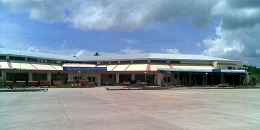
Veer Savarkar International Airport, commonly known as Port Blair Airport (IATA: IXZ, ICAO: VOPB), is an airport located 2 km (1.2 mi) south of Port Blair and is the main airport of the Andaman and Nicobar Islands of India. It is named after the Indian freedom fighter Vinayak Damodar Savarkar. Overview
The airport has a single runway of 3,290 m (10,794 ft) in length, accommodating most wide-body aircraft, although the most recent reports indicate no airliners larger than Airbus 320 types regularly serve Vir Savakar airport. An ILS (precision instrument landing system) is available for low visibility operations, but pilots are responsible to check with local authorities to verify the system is operational, prior to flight. There is a road that crosses the runway; traffic must be stopped for aircraft to take off, similar to the Gibraltar Airport.
With such a small terminal and the isolation of the islands, flights that serve the airport are few and expensive.. Restricted Area Permits for the Andaman and Nicobar Islands are available on entry.
There is only one terminal with 2 gates and no airbridges. Buses are used to provide transportation from the terminal to the flights in the apron. As of April 2009, construction work to add a second airplane parking bay is in progress.
Heavy rain flooded the airport during May 2008 and halted traffic.
Airlines and destinations
| Airlines |
Destinations |
| Indian Airlines |
Chennai, Kolkata |
| Jet Airways |
Chennai, Hyderabad |
| JetLite |
Delhi, Kolkata |
| Kingfisher Airlines |
Chennai, Kolkata |
The above content comes from Wikipedia and is published under free licenses – click here to read more.
| General Info
|
| Country |
India
|
| ICAO ID |
VOPB
|
| Time |
UTC+5:30
|
| Latitude |
11.641161
11° 38' 28.18" N
|
| Longitude |
92.729744
092° 43' 47.08" E
|
| Elevation |
14 feet
4 meters
|
| Magnetic Variation |
001° W (01/06)
|
| Operating Agency |
CIVIL GOVERNMENT, (LANDING FEES AND DIPLOMATIC CLEARANCE MAY BE REQUIRED)
|
| Island Group |
S. Andaman I
|
| Communications
|
TWR
Opr 0030-0730Z.
|
123.5
118.1
|
| ATIS |
126.4
|
APP
Opr 0100-0730Z
|
118.1
|
RDO
HO.
|
6583
8861
|
| Runways
|
| ID |
Dimensions |
Surface |
PCN |
ILS
|
| 04/22 |
10795 x 148 feet
3290 x 45 meters |
ASPHALT |
070FCXT |
NO
|
| Navaids
|
| Type |
ID |
Name |
Channel |
Freq |
Distance From Field |
Bearing From Navaid
|
| VOR-DME |
PPB |
PORT BLAIR |
104X |
115.7 |
1.1 NM |
244.8
|
| Supplies/Equipment
|
| Fuel |
Jet fuel avaiable but type is unknown.
|
| Remarks
|
| RSTD |
Daylt Opr only.
|
The content above was published at Airports-Worldwide.com in 2010.
We don't guarantee the information is fresh and accurate. The data may be wrong or outdated.
For more up-to-date information please refer to other sources.
|
|


