|
|
| Chabua Air Force Station

|
 |
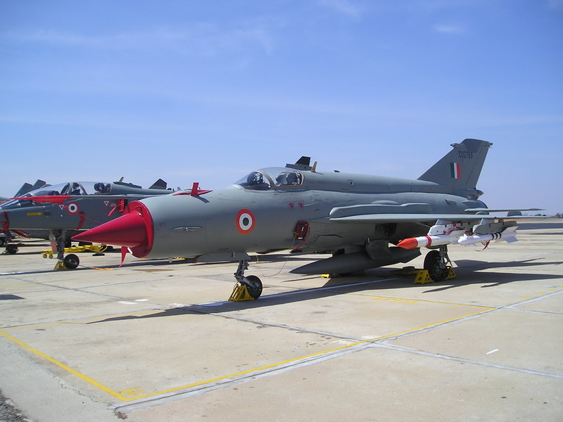
| IAF Mig-21 |
| IATA: none – ICAO: VECA |
| Summary |
| Airport type |
Military |
| Operator |
Indian Air Force |
| Location |
Chabua, Assam, India |
| Elevation AMSL |
367 ft / 112 m |
| Coordinates |
27°27′44″N 095°07′05″E / 27.46222°N 95.11806°E / 27.46222; 95.11806 |
| Runways |
| Direction |
Length |
Surface |
| m |
ft |
| 05/23 |
2,744 |
9,003 |
Asphalt |
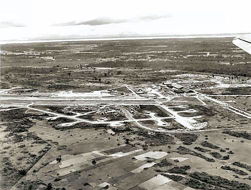 | |
Chabua Airfield, 1944 |
Chabua Air Force Station (ICAO: VECA) is an Indian Air Force base located at Chabua in the state of Assam, India.
Currently used as a training airfield, the MiG-21 (FL) fighters assigned train young fighter pilots, thus, enabling a smooth transition to an operational role in the frontline squadrons of IAF. The unit calls itself ‘the young ones’. Formed in October, 1966 with the motto Abhyasen hi Kaushalayam, the unit has a glorious and chequered history since its establishment. Seven Vir Chakra, a Vayu Sena Medal and five Mention-in-Despatches won by the unit is a testimony to the gallantry of the unit. More recently, the unit has been declared as the `best fighter squadron' of EAC for the current year. History
This Base was built in 1939. During World War II it was a major supply point for the ferrying of supplies to Generalissimo Chiang Kai-shek's forces in and around Kunming, China. This was known as "Flying the Hump".
The Japanese occupation of Burma in 1942 had cut off the Burma Road, the last land route by which the Allies could deliver aid to the Chinese Government of Chiang Kai-shek. Until the Burma Road could be retaken and the Ledo Road completed, the only supply route available was the costly and dangerous route for transport planes over the Himalayas between India'a Assam Valley and Kunming, China. This route became known as the Himalayan Hump or simply The Hump.
Operated initially by the United States Army Air Forces Ferrying Command (Later Air Transport Command) China Ferrying Command (later ATC India China Wing). The 1st Ferrying (later Transport) Group operated three squadrons of C-47 Skytrain and C-46 Commando aircraft from Chabua. The airfield was also an important layover stop of the ATC Karachi-Kunming air transport route. Flights operated west to Agra Airport, Willingdon Airfield (New Delhi), Gaya Airport, Assam (Borjhar Airport) and east into Dali Airport, and Kunming (Wujiaba Airport) in China
While the route kept the transports relatively free from enemy attack (Enemy action destroyed only seven aircraft, killing 13 men) it led over rugged terrain, through violent storms, with snow and ice at the higher altitudes the planes flew over the mountains. Flying the Himalayan Hump would turn out to be some of the most dangerous flying in the world. Over the course of action there were 460 aircraft and 792 men lost. Still, the operations were a success. There were 167,285 trips that moved 740,000 tons of material to support Chinese troops and other Allied forces.
In addition to the ATC transport units, elements of the Tenth Air Force 380th Bombardment Group, 375th Bombardment Squadron operated B-24 Liberators from the airfield, flying long range bombardment missions into Burma, south China, Thailand (Bangkok) and well as French Indochina (Haiphong). A total of 8 B-24s were lost. Also the B-24s were used to ferry aircraft fuel into China.
The airfield was abandoned after the war. In 1962, in response to the Chinese invasion of Tibet and the subsequent threat it posed to the North-East, the IAF commenced operations from this airfield. Initially Dakotas and Vampires, later Hunters, Otters and Mi-4 helicopters commenced air operations form Chabua air base. In the mid-seventies, subsequent to the runway upgradation and renovation, the supersonic MiG-21 became the mainstay fighter aircraft operating from here till date.
On 1 June 2009 it was decided that the new Su-30 MKI's will be stationed at the airbase.
The above content comes from Wikipedia and is published under free licenses – click here to read more.
| General Info
|
| Country |
India
|
| ICAO ID |
VEJT
|
| Time |
UTC+5:30
|
| Latitude |
26.731528
26° 43' 53.50" N
|
| Longitude |
94.175536
094° 10' 31.93" E
|
| Elevation |
311 feet
95 meters
|
| Type |
Military
|
| Magnetic Variation |
000° W (01/06)
|
| Operating Agency |
MILITARY
|
| Operating Hours |
SUNRISE TO SUNSET (SR-SS)
|
| Communications
|
| TWR |
123.5
|
| APP |
119.7
|
| Runways
|
| ID |
Dimensions |
Surface |
PCN |
ILS
|
| 04/22 |
9000 x 150 feet
2743 x 46 meters |
CONCRETE. |
- |
NO
|
| Navaids
|
| Type |
ID |
Name |
Channel |
Freq |
Distance From Field |
Bearing From Navaid
|
| VOR-DME |
JHT |
JORHAT |
058X |
112.1 |
2.3 NM |
039.5
|
| NDB |
JT |
JORHAT |
- |
217 |
1.0 NM |
061.0
|
| Supplies/Equipment
|
| Fuel |
Jet A1, without icing nhibitor.
100/130 MIL Spec, low lead, aviation gasoline (BLUE)
|
| Remarks
|
| FUEL |
(NC-100LL,115,A1)
|
| OPR HOURS |
Opr SR-SS.
|
The content above was published at Airports-Worldwide.com in 2010.
We don't guarantee the information is fresh and accurate. The data may be wrong or outdated.
For more up-to-date information please refer to other sources.
|
|