Begumpet Airport
బేగంపేట విమానాశ్రయము
حیدرآباد ائیرپورٹ
Hyderabad Airport |
 |
| IATA: none – ICAO: VOHY |
| Summary |
| Airport type |
Military/Public |
| Owner |
gmr at atime |
| Operator |
Airports Authority of India |
| Location |
Hyderabad, India |
| Elevation AMSL |
1,742 ft / 531 m |
| Coordinates |
17°27′11″N 078°28′03″E / 17.45306°N 78.4675°E / 17.45306; 78.4675 |
| Website |
aai.aero/allAirports/... |
| Runways |
| Direction |
Length |
Surface |
| ft |
m |
| 09/27 |
10,600 |
3,231 |
Asphalt |
| Ceased Operations Effective March 23rd 2008 |
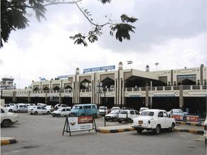
Begumpet Airport (ICAO: VOHY) at Hyderabad, also known as Hyderabad Airport, used to be the only international airport in Andhra Pradesh, but however, it is now defunct with the opening of the Hyderabad International Airport on the 23rd March 2008. It is a civil enclave located in Begumpet. The airport is host to the Andhra Pradesh Aviation Academy, Rajiv Gandhi Aviation Academy (RGAA) and the Begumpet Air Force Station of the Indian Air Force as well.
Begumpet airport used to provide two check-in terminals; Rajiv Gandhi International and NTR National with a common arrival module. The airport handled both international and domestic traffic for Hyderabad and was the 6th busiest airport in India. It was the largest hub of Air Sahara with 126 flights.
Begumpet airport had 13 parking bays in operation around the new terminal block and five more are used as "night parking bays" on the Northern side, next to the old block. This is sufficient to handle the A 320 and Boeing 737. These parking bays could comfortably handle flights considering the growth rate over the next three years,
With the replacement by Hyderabad International Airport in March, 2008, Begumpet, which is located in the heart of the Hyderabad metropolitan area, is now used for military aviation training and for flights carrying VIPs. The Leftist political parties have made strong representations to the civil aviation ministry to allow Begumpet airport to continue to be used for low cost civil aviation purposes for which it seems ideally suited. The Civil Aviation Ministry has put the proposal of starting an ATC training centre in the Begumpet Airport.
The airport used to have limited night landing facilities and only 40% of Andhra Pradesh's international traffic flows through the airport, due to lack of direct flights. President George W. Bush's Air Force One landed and took off from Begumpet during his visit to Hyderabad in early 2006. Begumpet airport's capacity has reportedly been exceeded in both domestic and international areas due to the rate of growth in passenger traffic, estimated at 45% p.a., last year, the highest among Indian airports. Begumpet Airport handled 20,000 passengers daily with about 300 aircraft movements of 16 international and 10 domestic airlines. Begumpet's capacity endowment was more than expected to start with or it has fine tuned its slot control regime to cope better with demand. All this raises questions about the actual use to which the IAF puts this base and why it cannot be kept open in future.
The state government has great hopes of establishing new airports in 8 towns and connecting them to Hyderabad and other existing airports. The last flight to take off was Thai Airways International flight TG 330 to Bangkok on 22 March 2008. History
 | |
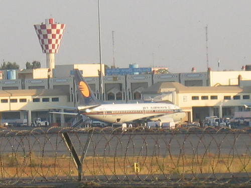
A Flight landed at the airport, when operational |
Begumpet Airport was established in the 1930s with formation of Hyderabad Aero Club. Initially it was used by Nizam of Hyderabad as domestic and international airport for The Nizam's Deccan Airways, one of the premier and the earliest airline in British India. The terminal building was created in 1937.. A new terminal building came up on the south side and later became the main airport. The older terminal hitherto was referred to as 'Old Airport'at Begumpet.
Begumpet Airport hosted the India Civil Aviation Airshow 2008 from October 15 to October 18, 2008, the first civilian air show in India.
General Aviation and Training
After the closure of Begumpet Airport for commercial flights, it is being used for aviation and flight training purposes by A.P. Aviation Academy and Rajiv Gandhi Aviation Academy. Training flights fly only to the south of the airport because of the northern part of the airport being a prohibited airspace for commercial flights.
The above content comes from Wikipedia and is published under free licenses – click here to read more.
| General Info
|
| Country |
India
|
| ICAO ID |
VOHY
|
| Time |
UTC+5:30
|
| Latitude |
17.453117
17° 27' 11.22" N
|
| Longitude |
78.467586
078° 28' 03.31" E
|
| Elevation |
1742 feet
531 meters
|
| Type |
Joint (Civil and Military)
|
| Magnetic Variation |
001° W (01/06)
|
| Beacon |
Yes
|
| Operating Agency |
MILITARY - CIVIL JOINT USE AIRPORT
|
| Communications
|
| TWR |
122.25
|
RDO
2872,6583 Opr; 1630-0030Z; 8861,8909 Opr 0000-1630Z.
|
2872
6583
6655
8861
8909
|
| ATIS |
126.8
|
| APP |
132.4
|
| ACC |
129.7
118.3
|
| Runways
|
| ID |
Dimensions |
Surface |
PCN |
ILS
|
| 09/27 |
10600 x 148 feet
3231 x 45 meters |
ASPHALT |
066FBXT |
YES
|
| Navaids
|
| Type |
ID |
Name |
Channel |
Freq |
Distance From Field |
Bearing From Navaid
|
| VOR-DME |
HHY |
HYDERABAD |
094X |
114.7 |
At Field |
-
|
| Remarks
|
| CAUTION |
Bird haz
|
| FUEL |
(NC-100LL, A1)
|
| RSTD |
Rwy 14-32 unuse for ldg/tkof of acft. Avbl only for taxiing.
|
The content above was published at Airports-Worldwide.com in 2010.
We don't guarantee the information is fresh and accurate. The data may be wrong or outdated.
For more up-to-date information please refer to other sources.
|