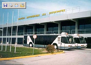
Kos International Airport "Hippocrates" |
 Airport
History Airport
History
Kos International Airport "Hippocrates", is found in the village
Antimachia, in distance 27 kms from the centre of Kos.
The beginning of operation of Kos International Airport became on 4 April
1964, with runway manufactured from open type asphalt, length of 1200
metres.
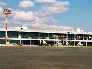
In October 1980 in order to cover the increasing needs of passengers movements,
was inaugurated the new Terminal, while the runway had been extended in
the 2400 metres already from 1973. In 1997 a new building of arrivals
was added in his Airport installations.
Thus the total area of building installations reaches the 3000 m2.
KOS is the 6th airport in Greece asfar as traffic is concerned (during
summer).
Regarding traffic, best days are Wed (UK), Fri (Holland) and Sunday (Scandinavia).
Nothing from Eastern Europe and Russia. Those days usually the West appron
is also used.
AIRPORT INFORMATION
Tower:121.05 Approach: 119.95 ATIS:126.95
Note that KOS is Civil Aviation airport only. There are no military/Air
Force installations, so photos are generally allowed.
VIEWING AREAS
Here is a church on a small hill. The runway 98% in use is 33 so most
of the traffic is entering into the appron via taxiway A. A 35-70mm lens
is covering all aircraft types when passing in front of you. From that
place with a 210mm lens you can cover all the appron, even to parking
possition 4 hosting a 737, and also with a 210mm lens you can take good
pictures during take-off roll with the sun behind you untill about 1400L.
 Coordinates: Coordinates:
Kos Island International Airport, "Hippocrates"
Postal Address:
Kos International Airport "Hippocrates" 85302 KOS
Tel +30 22420 56000
Fax: +30 22420 51833
E-mail : kakoitl at otenet gr
WEB: http://www.hcaa-eleng.gr/kos.htm
Images and information placed above are from
http://www.hcaa-eleng.gr/kos.htm
We thank them for the data!
| General Info
|
| Country |
Greece
|
| ICAO ID |
LGKO
|
| Time |
UTC+2(+3DT)
|
| Latitude |
36.793336
36° 47' 36.01" N
|
| Longitude |
27.091667
027° 05' 30.00" E
|
| Elevation |
412 feet
126 meters
|
| Type |
Civil
|
| Magnetic Variation |
003° E (01/05)
|
| Beacon |
Yes
|
| Operating Hours |
SEE REMARKS FOR OPERATING HOURS OR COMMUNICATIONS FOR POSSIBLE HOURS
|
| Daylight Savings Time |
Last Sunday in March to last Sunday in October
|
| Communications
|
| IPPOKRATIS TWR |
121.05
122.1
257.8
|
ATIS
Opr 0600-2000Z++ 1 Apr-31 Oct.
|
126.95
|
| IPPOKRATIS APP |
119.95
122.1
|
| IPPOKRATIS RDO |
5637
2989
(5637 Opr 0400-1700Z++) (2989 Opr 1700-0400Z++)
|
| Runways
|
| ID |
Dimensions |
Surface |
PCN |
ILS
|
| 14/32 |
7841 x 148 feet
2390 x 45 meters |
ASPHALT |
040FAXU |
NO
|
| Navaids
|
| Type |
ID |
Name |
Channel |
Freq |
Distance From Field |
Bearing From Navaid
|
| VOR-DME |
KOS |
KOS |
027X |
109 |
At Field |
-
|
| NDB |
KOS |
KOS |
- |
311 |
At Field |
-
|
| Supplies/Equipment
|
| Fuel |
Jet A1, without icing nhibitor.
|
| Remarks
|
| CAUTION |
Bird haz, seagull concentration on rwy and vcnty of arpt.
|
| CSTMS/IMG |
Avbl H24.
|
| FUEL |
(NC-100LL, A1)
|
| LGT |
ABn, green coded KOS.
|
| OPR HOURS |
Opr HO (H24 sum).
|
| RSTD |
All landing acft should back track at end of rwy. Use min pwr for taxi.
|
| RWY |
Rwy 14 all ldg and tkof make rgt turns, Rwy 32 all ldg and tkof make lt turns.
|
Runway 14/32
7841 x 148 feet
2390 x 45 meters
| Runway 14
|
| Surface |
ASPHALT
|
| True Heading |
148.0
|
| Latitude |
36.803639
36° 48' 13.10" N
|
| Longitude |
27.083639
027° 05' 01.10" E
|
| Elevation |
412.0 feet
126 meters
|
| Slope |
-0.5°
|
| Landing Distance |
7841 feet
2390 meters
|
| Takeoff Distance |
8046 feet
2452 meters
|
| Overrun Length |
205 feet
62 meters
|
| Overrun Surface |
GRADED OR ROLLED EARTH, GRASS ON GRADED EARTH.
|
| Lighting System |
MIRL
A2
PAPI |
| Runway 32
|
| Surface |
ASPHALT
|
| True Heading |
328.0
|
| Latitude |
36.785167
36° 47' 06.60" N
|
| Longitude |
27.097889
027° 05' 52.40" E
|
| Elevation |
372.0 feet
113 meters
|
| Slope |
0.5°
|
| Landing Distance |
7841 feet
2390 meters
|
| Takeoff Distance |
8081 feet
2463 meters
|
| Overrun Length |
240 feet
73 meters
|
| Overrun Surface |
ASPHALT
|
| Lighting System |
MIRL
REIL
PAPI |
Navaids
| KOS
|
| Type |
ID |
Channel |
Freq |
Country |
State
|
| VOR-DME |
KOS |
027X |
109 |
Greece |
-
|
| Latitude |
Longitude |
Airport
|
36.790556
36° 47' 26.00" N |
27.091111
027° 05' 28.00" E |
LGKO |
Navaids
| KOS
|
| Type |
ID |
Channel |
Freq |
Country |
State
|
| NDB |
KOS |
- |
311 |
Greece |
-
|
| Latitude |
Longitude |
Airport
|
36.795278
36° 47' 43.00" N |
27.091111
027° 05' 28.00" E |
LGKO |
The content above was published at Airports-Worldwide.com in 2005.
We don't guarantee the information is fresh and accurate. The data may be wrong or outdated.
For more up-to-date information please refer to other sources.
|


