 |
 |
|
||||
|
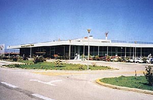
Kefalonia International Airport was founded and functioned the year 1971.
In the years that intervened up to today took place progressively a multilevel work of growth and modernization of Airport. Thus today Kefalonia International Airport provides high level air services and facilitations in, with impressive rythms, progressively increasing movement of planes and passenger public. It is indicatively marked that the Airport allocates modern, completely equipped building Installations of area 4,500 m2, one runway with dimensions 2,440 x 45 m., suitable for almost each type of plane, with light marking, optical aids and navaids. Also, it provides aircrafts parking stands within an area of 23,000 m2 and additionals parking stands for small aircrafts, within an area of 3,500 m2 . The Control Tower building is equipped with all the necessarily modern Telecommunications and aviation electronic systems. Today, the Fire station covers a Cat. 6 requirements with a perspective of its upgrade. Also, There is in progress an ambitious program of further Airport growth that concerns in the improvement of all nature of infrastructures, its functionalism, safety and his appearance. Kefalonia Greece, Travel information about Kefalonia airport: The transfer time between the airport and the capital is only a few minutes
by car; but because of the large size of Kefalonia (it is the largest
island of the Ionian Islands), some resorts or villages can be separated
by a distance over 50 kilometres from the airport. Kefalonia Island International Airport Postal Address: 28100 Minies KEFALONIA Tel : +30 26710 29900 E-mail : kakftl (at) hcaa . gr WEB: http://kefaloniaairport.info
Images and information placed above are from
Runway 14/327992 x 148 feet
|
||||||||||||||||||||||||||||||||||||||||||||||||||||||||||||||||||||||||||||||||||||||||||||||||||||||||||||||||||||||||||||||||||||||||||||||||||||||||||||||||||||||||||||||||||||||||||||||||||||||||||||||||||||||||||
| Runway 14 | |
|---|---|
| Surface | ASPHALT |
| True Heading | 146.0 |
| Latitude | 38.129175 38° 07' 45.03" N |
| Longitude | 20.492789 020° 29' 34.04" E |
| Elevation | 31.0 feet 9 meters |
| Slope | 0.2° |
| Landing Distance | 7992 feet 2436 meters |
| Takeoff Distance | 7992 feet 2436 meters |
| Lighting System | HIRL |
| Runway 32 | |
|---|---|
| Surface | ASPHALT |
| True Heading | 326.0 |
| Latitude | 38.110964 38° 06' 39.47" N |
| Longitude | 20.508172 020° 30' 29.42" E |
| Elevation | 50.0 feet 15 meters |
| Slope | -0.2° |
| Landing Distance | 7080 feet 2158 meters |
| Takeoff Distance | 8172 feet 2491 meters |
| Displaced Threshold Length | 912 feet 278 meters |
| Overrun Length | 180 feet 55 meters |
| Overrun Surface | CONCRETE. |
| Lighting System | HIRL |
| KEFALLINIA | |||||
|---|---|---|---|---|---|
| Type | ID | Channel | Freq | Country | State |
| VOR-DME | KFN | 102X | 115.5 | Greece | - |
| Latitude | Longitude | Airport |
| 38.113056 38° 06' 47.00" N |
20.504722 020° 30' 17.00" E |
LGKF |
| KEFALLINIA | |||||
|---|---|---|---|---|---|
| Type | ID | Channel | Freq | Country | State |
| NDB | KEF | - | 318 | Greece | - |
| Latitude | Longitude | Airport |
| 38.115653 38° 06' 56.35" N |
20.499300 020° 29' 57.48" E |
LGKF |
The content above was published at Airports-Worldwide.com in 2005.
We don't guarantee the information is fresh and accurate. The data may be wrong or outdated.
For more up-to-date information please refer to other sources.

 |
|
Copyright 2004-2024 © by Airports-Worldwide.com, Vyshenskoho st. 36, Lviv 79010, Ukraine Legal Disclaimer |
 Airport
History
Airport
History 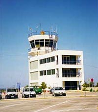 Coordinates: