|
 |
|
||||
|
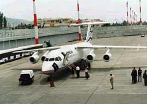
Alexandroupolis International Airport "Dimokritos"
The Government owned Airport Alexandroupoli "DIMOKRJTOS" is found in distance of 7 km from centre of city of Alexandroupoli in the Thrace. The access in the Airport becomes via International road E90 that connects Greece with Turkey. In future will exist access via the Road Egnatia. The initial Airport was created 1944. Travelers info Overnight accommodations: Hotels at Alexandroupolis town. Flying Club In the airport functions the Alexandroupolis Aero club which is activated
in the distribution of Aero athleticism as well as the learning of handling
of volatile means (plane). Coordinates: Alexandroupolis International Airport "Dimokritos" Postal: Alexandroupolis International Airport , Dimokritos
Tel: +3 25510 45259 E-mail: kaaldtl at otenet gr WEB: http://www.alxd.gr/ Images and information placed above are from
Runway 07/258471 x 148 feet
|
||||||||||||||||||||||||||||||||||||||||||||||||||||||||||||||||||||||||||||||||||||||||||||||||||||||||||||||||||||||||||||||||||||||||||||||||||||||||||||||||||||||||||||||||||||||||||||||||||||||||||||||||||||||||||||||||
| Runway 07 | |
|---|---|
| Surface | ASPHALT |
| True Heading | 073.0 |
| Latitude | 40.852492 40° 51' 08.97" N |
| Longitude | 25.941711 025° 56' 30.16" E |
| Elevation | 8.0 feet 2 meters |
| Slope | 0.2° |
| Landing Distance | 8471 feet 2582 meters |
| Takeoff Distance | 8671 feet 2643 meters |
| Overrun Length | 200 feet 61 meters |
| Overrun Surface | ASPHALT |
| Lighting System | HIRL
A2 PAPI |
| Runway 25 | |
|---|---|
| Surface | ASPHALT |
| True Heading | 253.0 |
| Latitude | 40.859247 40° 51' 33.29" N |
| Longitude | 25.970817 025° 58' 14.94" E |
| Elevation | 24.0 feet 7 meters |
| Slope | -0.2° |
| Landing Distance | 8471 feet 2582 meters |
| Takeoff Distance | 8671 feet 2643 meters |
| Overrun Length | 200 feet 61 meters |
| Overrun Surface | ASPHALT |
| Lighting System | HIRL
A2 PAPI |
| ALEXANDROUPOLIS | |||||
|---|---|---|---|---|---|
| Type | ID | Channel | Freq | Country | State |
| VOR-DME | ALX | 085X | 113.8 | Greece | - |
| Latitude | Longitude | Airport |
| 40.855000 40° 51' 18.00" N |
25.957222 025° 57' 26.00" E |
LGAL |
| ALEXANDROUPOLIS | |||||
|---|---|---|---|---|---|
| Type | ID | Channel | Freq | Country | State |
| NDB | ALP | - | 351 | Greece | - |
| Latitude | Longitude | Airport |
| 40.857500 40° 51' 27.00" N |
25.944167 025° 56' 39.00" E |
LGAL |
The content above was published at Airports-Worldwide.com in 2005.
We don't guarantee the information is fresh and accurate. The data may be wrong or outdated.
For more up-to-date information please refer to other sources.

 |
|
Copyright 2004-2024 © by Airports-Worldwide.com, Vyshenskoho st. 36, Lviv 79010, Ukraine Legal Disclaimer |