|
 |
|
||||
|
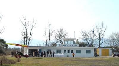
Agrinion Aeroclub is based in Agrinion' s old Civil
Airport. It' s use has been given to our aeroclub by the Authorities of
Civil Aviation after the departure of Olympic Airways from the airport.
Our members of paragliding (parapente) section use the tracks of Vlacherna,
Empessos and Palaiokarya.
From the national road when you are outside Agrinion you take the turn to Dokimi and follow the road. When you will see a kiosk to the right slow down gradually and watch to the left. You will see a plate with an arrow showing the way to Agrinion Aeroclub. You turn to the left and you will see the airport. Agrinion Aeroclub Member of the Hellenic Aeronautical and Airsports Federation Agrinion Civil Airport Tel.: 26410-28724 E-mail: kostopk at agr forthnet gr Images and information placed above are from
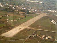
Runway 09/279875 x 98 feet
|
||||||||||||||||||||||||||||||||||||||||||||||||||||||||||||||||||||||||||||||||||||||||||||||||||||||||||||||||||||||||||||
| Runway 09 | |
|---|---|
| Surface | ASPHALT |
| True Heading | 093.0 |
| Latitude | 38.602733 38° 36' 09.84" N |
| Longitude | 21.333953 021° 20' 02.23" E |
| Landing Distance | 9875 feet 3010 meters |
| Takeoff Distance | 9935 feet 3028 meters |
| Overrun Length | 60 feet 18 meters |
| Overrun Surface | ASPHALT |
| Lighting System | PAPI |
| Runway 27 | |
|---|---|
| Surface | ASPHALT |
| True Heading | 273.0 |
| Latitude | 38.601408 38° 36' 05.07" N |
| Longitude | 21.368431 021° 22' 06.35" E |
| Landing Distance | 9875 feet 3010 meters |
| Takeoff Distance | 9935 feet 3028 meters |
| Overrun Length | 60 feet 18 meters |
| Overrun Surface | ASPHALT |
| Lighting System | PAPI |
The content above was published at Airports-Worldwide.com in 2005.
We don't guarantee the information is fresh and accurate. The data may be wrong or outdated.
For more up-to-date information please refer to other sources.

 |
|
Copyright 2004-2024 © by Airports-Worldwide.com, Vyshenskoho st. 36, Lviv 79010, Ukraine Legal Disclaimer |