 |
|
 The
Zweibrücken Airport as the nucleus of the region. The
Zweibrücken Airport as the nucleus of the region.
• The region is centrally located in Europe with a market area
of 345 million people.
• There is a population of 40 million people within a 200-kilometer
radius.
This area includes major German cities of Frankfurt, Wiesbaden, Mainz,
Trier, Saarbrücken,
Mannheim, Ludwigshafen and Karlsruhe. The French cities of Strasbourg,
Metz and Nancy
as well as Luxembourg are all within the 200-kilometer radius.
• An excellent highway and railway system runs both North-South
and East-West bound.
Major highways:
- A6: Connecting Paris via Zweibrücken with Central Germany and Europe
- A5: Connecting Basel, Switzerland with Frankfurt and Northern Germany
- A61: Connecting Mannheim / Ludwigshafen area with Koblenz and the Netherlands
- A63: Connecting Mainz / Wiesbaden / Frankfurt via A62 with the Zweibrücken
region.
Frequent departures (freight and passenger) quickly connect Kaiserslautern,
Paris, Frankfurt,
Stuttgart, Munich and numerous other locations throughout Central Europe.
 ICAO
Code EDRZ ICAO
Code EDRZ
IATA Code ZQW
Name ZWEIBRÜCKEN
Land Deutschland
Bundesland Rheinland-Pfalz
Letzte Änderung 24. Juli 2003
Kategorie Verkehrslandeplatz / Public Airfield
Betreiber / Operator Flughafen Zweibrücken GmbH
Lage / Location 2.8 NM SE Zweibrücken
Nachtflug / NVFR NVFR
Instrumentenflug / IFR IFR
LFZ / ACFT Bis / up to 14000 kg, PCN 45, PCN 55 PPR
Helicopter Ja / Yes
Motorsegler / GLDP Ja / Yes
Segelflugzeuge / GLD PPR
UL PPR
Summer Mon-Fri 0600-2000 (0400-0600 PPR), Sat, Sun, HOL 0700-1900 (0400-0700
+ 1900-2000 PPR)
Winter Mon-Fri 0700-2100 (0500-0700 PPR), Sat, Sun, HOL 0800-1800 (0500-0800
+ 1800-2100 PPR) PPR bis/till 1100 Fri oder/or workday vor/before HOL
O/T PPR
Schulflüge in der Platzrunde sowie Flüge mit Aufsetz und Durchstartübungen
sind an Sat ab 1200 (1100) sowie an Sun + HOL untersagt. Schulflug in
der Platzrunde nach Einbruch der Dunkelheit (SS+30) nur PPR. Diese Regelung
gilt auch für Luftfahrzeuge, die erhöhten Schallschutzanforderungen
entsprechen./Training flights at traffic circuit and touch-and-go landings
are prohibited an Sat from 1200 (1100) as well as on Sun and legal Hol.
Training flights at traffic circuit after the beginning of darkness (SS+30)
only PPR This regulation also applies to aircraft with increased noise
abatement requirements. Weitere Einschränkungen siehe AD 1-6 / Further
restrictions see AD 1-6
Luftaufsicht / OPS +49 (0)6332 / 41807, Fax 41658
PPR +49 (0)6332 / 41807, 974666, 9747
AIS AIS-Centre EDDZ, +49 (0)69 / 78072500
ACC EDDF +49 (0)6103 / 7076200
MET (0190) 077224
Gafor 44
Zoll / Customs PPR 24 HR für Flüge aus Ländern, die nicht
zum Schengener Abkommen gehören - Sat, Sun, HOL PPR letzter Arbeitstag/for
flights proceeding from countries not belonging to the Schengen agreement
- Sat, Sun, HOL PPR last working day
Fuel 100 LL, Jet A1
Oil ASO 80, 100, W80, W100, 15W50
Hangar Ja / Yes
Höhe / Elevation 1133 ft / 345 m
FIS Langen Information 123.525
VDF / QDM 123.825
Rufzeichen / Call sign Zweibrücken Info
Frequenz Tower 123.825 EN/GE
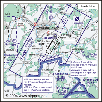
NAV Aids DME ZND 109.10 am Platz/at field 210°/0.5 NM from ZBN 435
108°/38 NM from KIR 117.50286°/48 NM from KRH 115.95
Koordinaten 49 12, 57 N / 07 24, 04 E
Platzrunde / Traffic circuit SE 2200
Landebahnen / RWY 1
RWY 2950 x 45 m, ASPHALT
RWY 03 TKOF 2675 m; LDG 2675 m
RWY 21 TKOF 2675 m; LDG 2675 m
MTOW 45 R/B/X/T, PPR 55 R/B/X/T
Bemerkungen / Remarks Wohngebiete meiden! Airspace F (HX) GND/1000 GND
Restaurant Ja
Adresse
Berliner Allee 11 - 21
ZIP / City D-66482
Zweibrücken
Fon +49 (0)6332 / 974640
Fax 974669/649
URL http://www.flughafen-zweibruecken.de
eMail info at flughafen-zweibruecken de
Images and information placed above are from
http://www.flughafen-zweibruecken.de
http://www.airports.de/airport.php?ICAO=EDRZ
We thank them for the data!
| General Info
|
| Country |
Germany
|
| ICAO ID |
EDRZ
|
| Time |
UTC+1(+2DT)
|
| Latitude |
49.209525
49° 12' 34.29" N
|
| Longitude |
7.400647
007° 24' 02.33" E
|
| Elevation |
1133 feet
345 meters
|
| Type |
Civil
|
| Magnetic Variation |
000° E (01/05)
|
| Beacon |
Yes
|
| Operating Agency |
CIVIL GOVERNMENT, (LANDING FEES AND DIPLOMATIC CLEARANCE MAY BE REQUIRED)
|
| Operating Hours |
SEE REMARKS FOR OPERATING HOURS OR COMMUNICATIONS FOR POSSIBLE HOURS
|
| Daylight Savings Time |
Last Sunday in March to last Sunday in October
|
| Communications
|
| LANGEN RADAR |
129.675
258.85
373.8
|
| LANGEN INFO |
123.525
|
| INFO |
123.825
|
| Runways
|
ID
|
Dimensions |
Surface |
PCN |
ILS
|
| 03/21 |
9678 x 148 feet
2950 x 45 meters |
CONCRETE. |
055RBXT |
YES
|
| Navaids
|
| Type |
ID |
Name |
Channel |
Freq |
Distance From Field |
Bearing From Navaid
|
| VOR-DME |
ZWN |
ZWEIBRUCKEN |
095X |
114.8 |
1.4 NM |
209.9
|
| NDB |
ZBN |
ZWEIBRUCKEN |
- |
435 |
1.3 NM |
209.9
|
| DME |
ZND |
ZWEIBRUCKEN |
028X |
- |
At Field |
-
|
| Supplies/Equipment
|
| Fuel |
Jet A1, without icing nhibitor.
100/130 MIL Spec, low lead, aviation gasoline (BLUE)
|
| Remarks
|
| CSTMS/IMG |
Avbl PPR 24 hr. Wkend and hol PPR last working day.
|
| FUEL |
(NC-100LL, A1)
|
| NS ABTMT |
Before 0600Z++, btn 1200-1400Z++, aft SS Mon-Fri. Before 0800Z++ and aft 1200Z++Sat, Sun, hol. No ovft of villages in arpt vcnty.
|
| OPR HOURS |
Opr 0700-2100Z++ Mon-Fri; 0800-1800Z++ Sat, Sun, hol.
|
| RSTD |
No trng apch 1100Z Sat-1900Z Sun and hol. OT PPR C06332-41807.
|
Runway 03/21
9678 x 148 feet
2950 x 45 meters
| Runway 03
|
| Surface |
CONCRETE.
|
| True Heading |
030.0
|
| Latitude |
49.198039
49° 11' 52.94" N
|
| Longitude |
7.390528
007° 23' 25.90" E
|
| Elevation |
1126.0 feet
343 meters
|
| Slope |
-0.1°
|
| Landing Distance |
8776 feet
2675 meters
|
| Takeoff Distance |
9678 feet
2950 meters
|
| Displaced Threshold Length |
902 feet
275 meters
|
| Lighting System |
HIRL
REIL
S
PAPI |
| Runway 21
|
| Surface |
CONCRETE.
|
| True Heading |
210.0
|
| Latitude |
49.221006
49° 13' 15.62" N
|
| Longitude |
7.410775
007° 24' 38.79" E
|
| Elevation |
1115.0 feet
340 meters
|
| Slope |
0.1°
|
| Landing Distance |
8776 feet
2675 meters
|
| Takeoff Distance |
9678 feet
2950 meters
|
| Displaced Threshold Length |
902 feet
275 meters
|
| Lighting System |
HIRL
REIL
S
PAPI |
Navaids
| ZWEIBRUCKEN
|
| Type |
ID |
Channel |
Freq |
Country |
State
|
| VOR-DME |
ZWN |
095X |
114.8 |
Germany |
-
|
| Latitude |
Longitude |
Airport
|
49.229072
49° 13' 44.66" N |
7.417892
007° 25' 04.41" E |
EDRZ |
Navaids
| ZWEIBRUCKEN
|
| Type |
ID |
Channel |
Freq |
Country |
State
|
| NDB |
ZBN |
- |
435 |
Germany |
-
|
| Latitude |
Longitude |
Airport
|
49.227592
49° 13' 39.33" N |
7.416583
007° 24' 59.70" E |
EDRZ |
Navaids
| ZWEIBRUCKEN
|
| Type |
ID |
Channel |
Freq |
Country |
State
|
| DME |
ZND |
028X |
- |
Germany |
-
|
| Latitude |
Longitude |
Airport
|
49.209331
49° 12' 33.59" N |
7.395778
007° 23' 44.80" E |
EDRZ |
The content above was published at Airports-Worldwide.com in 2005.
We don't guarantee the information is fresh and accurate. The data may be wrong or outdated.
For more up-to-date information please refer to other sources.
|
|


