|
 |
|
||||
|
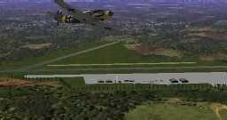
Wunstorf (Kleinheidorn) Airfield Military GAF (Bundeswehr Luftwaffe) Photo © Edmundo Abad
Images and information placed above are from
Runway 03/215573 x 156 feet
|
||||||||||||||||||||||||||||||||||||||||||||||||||||||||||||||||||||||||||||||||||||||||||||||||||||||||||||||||||||||||||||||||||||||||||||||||||||||||||||||||||||||||||||||||||||||||||||||||||||||||||||||||||||||||||||||||||||||||||||||||||||||||||||||||||||||||||||||||||||||||||||||||||||||||||||||||||||||||||
| Runway 03 | |
|---|---|
| Surface | ASPHALT |
| True Heading | 026.0 |
| Latitude | 52.445000 52° 26' 42.00" N |
| Longitude | 9.427000 009° 25' 37.20" E |
| Elevation | 179.4 feet 55 meters |
| Slope | -0.2° |
| Landing Distance | 5573 feet 1699 meters |
| Takeoff Distance | 5573 feet 1699 meters |
| Lighting System | SF
HIRL J |
| Runway 21 | |
|---|---|
| Surface | ASPHALT |
| True Heading | 206.0 |
| Latitude | 52.458667 52° 27' 31.20" N |
| Longitude | 9.438333 009° 26' 18.00" E |
| Elevation | 169.8 feet 52 meters |
| Slope | 0.2° |
| Landing Distance | 5573 feet 1699 meters |
| Takeoff Distance | 5573 feet 1699 meters |
| Lighting System | SF
HIRL J |
| Runway 08 | |
|---|---|
| Surface | ASPHALT |
| True Heading | 081.0 |
| Latitude | 52.456167 52° 27' 22.20" N |
| Longitude | 9.413500 009° 24' 48.60" E |
| Elevation | 171.8 feet 52 meters |
| Slope | 0.0° |
| Landing Distance | 6157 feet 1877 meters |
| Takeoff Distance | 6157 feet 1877 meters |
| Lighting System | SF
HIRL BP PAPI |
| Runway 26 | |
|---|---|
| Surface | ASPHALT |
| True Heading | 261.0 |
| Latitude | 52.458500 52° 27' 30.60" N |
| Longitude | 9.440833 009° 26' 27.00" E |
| Elevation | 171.0 feet 52 meters |
| Slope | 0.0° |
| Landing Distance | 6157 feet 1877 meters |
| Takeoff Distance | 6157 feet 1877 meters |
| Lighting System | SF
HIRL BP PAPI |
| Runway 08R | |
|---|---|
| Surface | GRASS OR EARTH NOT GRADED OR ROLLED. |
| True Heading | 081.0 |
| Latitude | 52.454833 52° 27' 17.40" N |
| Longitude | 9.416333 009° 24' 58.80" E |
| Elevation | 169.0 feet 52 meters |
| Slope | -0.1° |
| Landing Distance | 3569 feet 1088 meters |
| Takeoff Distance | 3569 feet 1088 meters |
| Runway 26L | |
|---|---|
| Surface | GRASS OR EARTH NOT GRADED OR ROLLED. |
| True Heading | 261.0 |
| Latitude | 52.456333 52° 27' 22.80" N |
| Longitude | 9.432167 009° 25' 55.80" E |
| Elevation | 167.0 feet 51 meters |
| Slope | 0.1° |
| Landing Distance | 3569 feet 1088 meters |
| Takeoff Distance | 3569 feet 1088 meters |
| WUNSTORF | |||||
|---|---|---|---|---|---|
| Type | ID | Channel | Freq | Country | State |
| TACAN | WUN | 095Y | - | Germany | - |
| Latitude | Longitude | Airport |
| 52.460333 52° 27' 37.20" N |
9.444833 009° 26' 41.40" E |
ETNW |
| WUNSTORF | |||||
|---|---|---|---|---|---|
| Type | ID | Channel | Freq | Country | State |
| NDB | WUN | - | 419 | Germany | - |
| Latitude | Longitude | Airport |
| 52.459267 52° 27' 33.36" N |
9.454658 009° 27' 16.77" E |
ETNW |
The content above was published at Airports-Worldwide.com in 2005.
We don't guarantee the information is fresh and accurate. The data may be wrong or outdated.
For more up-to-date information please refer to other sources.

 |
|
Copyright 2004-2026 © by Airports-Worldwide.com, Vyshenskoho st. 36, Lviv 79010, Ukraine Legal Disclaimer |