 |
 |
|
||||
|
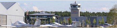
As the largest airfield in Brandenburg and the "New Countries" of the Federal Republic of Germany we are a key player in the aviation industry and - with our expanding technology park - an outstanding location for innovative enterprises. Here you'll find airplane and helicopter shipyards, avionics specialists and aircraft manufacturers, flight schools and charter enterprises, flying associations and catering services.
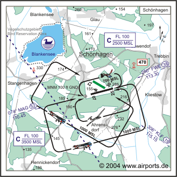
Flying began at Schönhagen in 1934. Today Schonhagen – situated 40 km south of Berlin centre – is one of the most important airfields in Brandenburg and among the biggest and busiest in Germany. Nearly half the air traffic here is commercial flights (46%), with private/leisure flights making up 34% and military and outpatient clinic flights contributing 20%. At the heart of the 114 hectar airfield are the two runways. The strip 07/25 is at present 1,200 m long and certified for a maximum take-off weight of 5,7 t. An extension is planned to take the strip up to 1.550 m in length which will carry aircraft of up to 12 t. The grass strip 12/30 has an area of 700 x 30 m and is certified for a maximum take-off weight of 2 t. It is to be asphalted and be developed on an area of 700 x 18 m. In 1991 Schöenhagen Ltd took over the running of the airfield and has since then worked consistently on its expansion. Several halls and auxiliary buildings of the aviation technology park have been developed, and while the runways are being developed further new buildings are in the planning stage. Today approximately 110 workers are employed by 18 companies on the airfield. In the medium term an expansion to about 300 employees is planned – driven by the expansion of existing companies and the setup of further new companies. With the sites continued expansion and development Schönhagen airfield is destined to become an important feature in the economic landscape of the region.
Kategorie Verkehrslandeplatz / Public Airfield Zoll / Customs Mon-Do 0700-1800 Fr 0700-1600 O/T PPR Images and information placed above are from http://www.edaz.de http://www.airports.de/airport.php?ICAO=EDAZ We thank them for the data!
Runway 07/253937 x 75 feet
|
|||||||||||||||||||||||||||||||||||||||||||||||||||||||||||||||||||||||||||||||||||||||||||||||||||||||||||||||||||||||||||||||||||||||||||||||||||||||||||||||||
| Runway 07 | |
|---|---|
| Surface | ASPHALT |
| True Heading | 076.0 |
| Latitude | 52.201953 52° 12' 07.03" N |
| Longitude | 13.149892 013° 08' 59.61" E |
| Landing Distance | 2721 feet 829 meters |
| Takeoff Distance | 3937 feet 1200 meters |
| Displaced Threshold Length | 1216 feet 371 meters |
| Lighting System | LIRL |
| Runway 25 | |
|---|---|
| Surface | ASPHALT |
| True Heading | 256.0 |
| Latitude | 52.204553 52° 12' 16.39" N |
| Longitude | 13.166914 013° 10' 00.89" E |
| Landing Distance | 3132 feet 955 meters |
| Takeoff Distance | 3937 feet 1200 meters |
| Displaced Threshold Length | 805 feet 245 meters |
| Lighting System | LIRL
PAPI |
| Runway 12 | |
|---|---|
| Surface | GRASS OR EARTH NOT GRADED OR ROLLED. |
| True Heading | 126.0 |
| Latitude | 52.208775 52° 12' 31.59" N |
| Longitude | 13.155881 013° 09' 21.17" E |
| Landing Distance | 2296 feet 700 meters |
| Takeoff Distance | 2296 feet 700 meters |
| Runway 30 | |
|---|---|
| Surface | GRASS OR EARTH NOT GRADED OR ROLLED. |
| True Heading | 306.0 |
| Latitude | 52.205911 52° 12' 21.28" N |
| Longitude | 13.162214 013° 09' 43.97" E |
| Landing Distance | 2296 feet 700 meters |
| Takeoff Distance | 2296 feet 700 meters |
The content above was published at Airports-Worldwide.com in 2005.
We don't guarantee the information is fresh and accurate. The data may be wrong or outdated.
For more up-to-date information please refer to other sources.

 |
|
Copyright 2004-2026 © by Airports-Worldwide.com, Vyshenskoho st. 36, Lviv 79010, Ukraine Legal Disclaimer |
 ICAO
Code EDAZ
ICAO
Code EDAZ