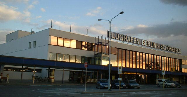
Schönefeld Berlin International Airport |
|
 |
(Click on the photo to enlarge) |
History:
1923
February 15: Negotiations open on allocating sufficient land for aviation
on the Tempelhof Field. Junkers and Aero Lloyd construct a wooden administration
building and two wooden hangars.
October 8: The Tempelhof Field is handed ever to the Junkers Airline and
the Deutsche Aero Lloyd by the Berlin City Council, and Tempelhof Airfield
is opened. A temporary concession was granted and so it was possible for
the first time to begin regular flights from Berlin to Munich and Berlin
to Königsberg.
1931
June 25: The square outside the air-port is given the name "Platz
der Luftbrücke" (Airlift Square) by the was possible for the
first time to begin regular flights from Berlin to Munich and Berlin to
Königsberg. Berlin Airport Authority takes over the administration
of the Berlin-Johannisthal Airport with the Versuchsanstalt für Luftfahrt
e.V. (Society for Aircraft Testing).
1945
April 22: A JU 52 flies to Warnemünde, the last Lufthansa aircraft
to take off at Tempelhof.
April 28/29: Soviet troops occupy the airport.
July 4: The Americans take over the airport.
1951
July 9: US commander returns Tempelhof to civil administration. The new
airport is opened with 2,000 square metres of passenger clearance area.
July 10: Inauguration of the Airlift Memorial, erected in honour of the
31 Americans, 40 Britons and five German pilots who lost their lives during
the Berlin Blockade.
1975
August 31: The two largest airlines, Pan Am and British Airways move from
Tempelhof to Tegel, as of September 1, the scheduled civilian flights
to and from Berlin are only from Tegel Airport.
1990
October 3: Air sovereignty handed over to the German authorities. For
the first time after 1945 business and private planes with German registration
land at Tempelhof.
October 26: Crossair is the first non-Allied airline to land, with a Saab
SF 340.
October 28/29: New Airlines in Tempelhof: Crossair, Delta Air, INTERFLUG,
RFG Regionalflug Interot Airways - Hamburg Airlines (November 26) - Tyrolean
Airways (December 23).
December 16: As other regional airlines are planning to fly from Tempelhof,
the large passenger clearance hall is reactivated. It is accessible via
the service area. DLT moves scheduled services from Tegel to Tempelhof.
LSG Berlin begins catering.
2003
March 31: The city-air airline starts immediately connecting Berlin with
the Mozart city Salzburg six times a week with a Saab 340B.
September 15: city-air commences flights between Berlin-Tempelhof and
Linz.
October 6: Starting immediately Denim Airways connects Berlin-Tempelhof
with the economic region Munich/Augsburg and Ulm daily except Saturdays.
October 13: The Austrian airline Intersky begins a connection between
Berlin-Tempelhof and Friedrichshafen with a Dash-8/300 Quiet.
|
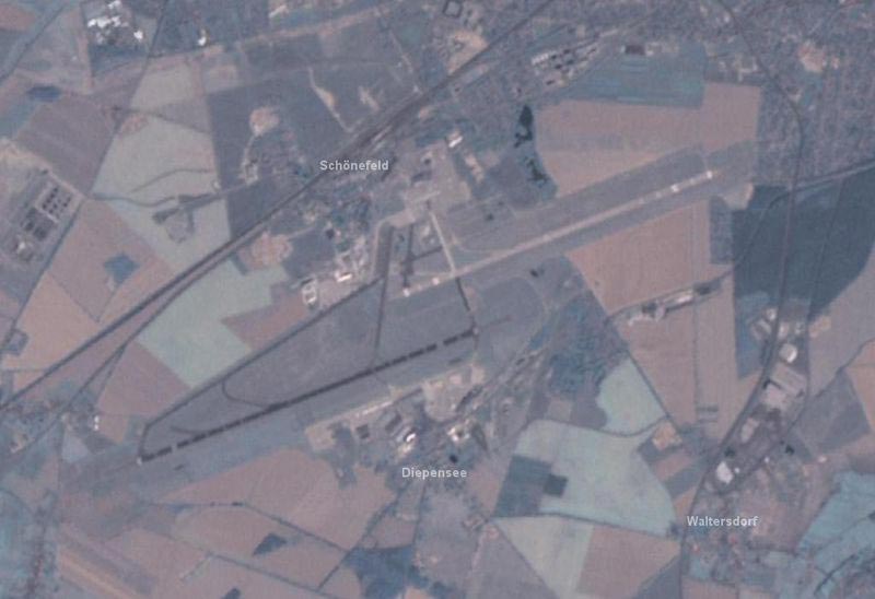
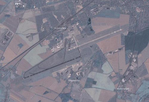 |
(Click on the photo to enlarge) |
ICAO Code EDDB
IATA Code SXF
Name BERLIN - Schönefeld
Land Deutschland
Bundesland Berlin
Letzte Änderung 20. Juni 2004
Kategorie Int. Verkehrsflughafen / Int. Airport
Betreiber / Operator Flughafen Berlin-Schönefeld GmbH -FBS-
Lage / Location 9.7 NM SE der Stadt/of the city
Nachtflug / NVFR NVFR
Instrumentenflug / IFR IFR
LFZ / ACFT Bis / up to 68/R/B/W/U
Helicopter Ja / Yes
Summer H 24
Winter H 24
CTR H 24
Luftaufsicht / OPS +49 (0)180 5000186
AIS EDDB +49 (0)30 / 60918250
ACC EDDB +49 (0)30 / 69512488
Tower Turm +49 (0)63496220, Fax 63496225
MET (0190) 077222
Gafor 17
Zoll / Customs H 24
Fuel 100 LL, Jet A1
Oil EE 80, EE 100, AV 80, AV 100, ASO 80, ASO 100, ASO W 80, ASO W 100,
ASO 15 W 50, D 20 W 50
Hangar Für LFZ bis 5700 kg und max. Spannweite von 15 m / for ACFT
up to 5700 kg and max. span of 15 m
Höhe / Elevation 155 ft / 47 m
FIS Berlin Info 126.350
VDF / QDM 120.025
Rufzeichen / Call sign Schönefeld Tower/Turm
Frequenz Tower 120.025 EN/GE
Frequenz Ground 121600
NAV Aids DME SDD 114.40 PAPI Pflichtmeldepunkt SIERRA
Koordinaten 52 22, 71 N / 13 31, 23 E
Landebahnen / RWY 2
RWY 3000 x 45 m, BITUMEN
RWY 07R TKOF 3000 m; LDG 3000 m
RWY 25L TKOF 3000 m; LDG 3000 m
MTOW PCN 140/R/B/W/U
RWY II 2710 x 45 m, CONCRETE
RWY 07L TKOF 2710 m; LDG 2710 m
RWY 25R TKOF 2710 m; LDG 2710 m
MTOW RWY II PCN 68 R/B/W/U
Restaurant Ja
Address:
ZIP / City D-12521
Berlin
+49 (0) 180 5000 186 - call center
URL http://www.berlin-airport.de
eMail pressestelle at berlin-airport de
Images and information placed above are from http://www.berlin-airport.de
http://www.airports.de/airport.php?ICAO=EDDB
http://en.wikipedia.org/wiki/Schonefeld_International_Airport
We thank them for the data!
Images from Wikipedia are available under the terms of the GNU Free Documentation
License
| General Info
|
| Country |
Germany
|
| ICAO ID |
EDDB
|
| Time |
UTC+1(+2DT)
|
| Latitude |
52.380000
52° 22' 48.00" N
|
| Longitude |
13.522500
013° 31' 21.00" E
|
| Elevation |
157 feet
48 meters
|
| Type |
Civil
|
| Magnetic Variation |
002° E (01/05)
|
| Beacon |
Yes
|
| Operating Agency |
CIVIL GOVERNMENT, (LANDING FEES AND DIPLOMATIC CLEARANCE MAY BE REQUIRED)
|
| Near City |
Berlin
|
| International Clearance Status |
Airport of Entry
|
| Daylight Savings Time |
Last Sunday in March to last Sunday in October
|
| Communications
|
| TWR |
120.025
127.875
358.6
|
| GND |
121.6
121.8
|
| BERLIN DIRECTOR |
136.1
121.125
40NM to FL100
|
| BERLIN DEP |
120.625
119.5
258.825
|
| ATIS |
124.95
|
| BERLIN ARR |
119.625
126.425
296.725
(119.625 NORTH, STARS to TERDA, LANUM )(132.7 SOUTH, STARS to KLF, FWE,ATGUP)
|
| BERLIN INFO |
126.35
|
| Runways
|
ID
|
Dimensions |
Surface |
PCN |
ILS
|
| 07R/25L |
9843 x 148 feet
3000 x 45 meters |
ASPHALT |
140RBWU |
YES
|
| 07L/25R |
8891 x 148 feet
2710 x 45 meters |
CONCRETE. |
068RBWU |
NO
|
| Navaids
|
| Type |
ID |
Name |
Channel |
Freq |
Distance From Field |
Bearing From Navaid
|
| NDB |
SLN |
SCHONEFELD |
- |
362 |
1.9 NM |
244.9
|
| DME |
SDD |
SCHONEFELD |
091X |
- |
At Field |
-
|
| Supplies/Equipment
|
| Fuel |
Unknown fuel type or whether there is any fuel.
|
| Oil |
Available (Types unknown)
|
| Remarks
|
| CAUTION |
Numerous cranes vcnty of rwy all quad. Bird haz.
|
| FUEL |
(NC-100LL, A1)
|
| LGT |
PAPI Rwy 07R MEHT 59.5', PAPI Rwy 07L MEHT 55', PAPI Rwy 25L MEHT 60'.
|
| MISC |
IFR FPL will be filed at least three hr prior to ETD, unless a repetitive FPL has been submitted. Extv reconstruction work close to and on Rwy 07R-25L dur ngt hr.
|
| RSTD |
Twy N avbl for acft with max 66' wingspan. Twy K btn Twy J and thld Rwy 25R clsdto acft with wingspan over 164'. Arr advs prior to apch, dep advs prior to taxi. Ldg and tkof proh 2100-0500Z++ exc emerg, evac, and SAR. Successive apch and dep for trng proh.
|
Runway 07R/25L
9843 x 148 feet
3000 x 45 meters
| Runway 07R
|
| Surface |
ASPHALT
|
| True Heading |
069.0
|
| Latitude |
52.367689
52° 22' 03.68" N
|
| Longitude |
13.485025
013° 29' 06.09" E
|
| Elevation |
146.0 feet
45 meters
|
| Slope |
0.1°
|
| Landing Distance |
9843 feet
3000 meters
|
| Takeoff Distance |
10827 feet
3300 meters
|
| Overrun Length |
984 feet
300 meters
|
| Overrun Surface |
ASPHALT
|
| Lighting System |
SF
TDZL
CL
HIRL
REIL
BS
PAPI |
| Runway 25L
|
| Surface |
ASPHALT
|
| True Heading |
249.0
|
| Latitude |
52.377431
52° 22' 38.75" N
|
| Longitude |
13.526097
013° 31' 33.95" E
|
| Elevation |
155.0 feet
47 meters
|
| Slope |
-0.1°
|
| Landing Distance |
9843 feet
3000 meters
|
| Takeoff Distance |
10827 feet
3300 meters
|
| Overrun Length |
984 feet
300 meters
|
| Overrun Surface |
ASPHALT
|
| Lighting System |
SF
TDZL
CL
HIRL
REIL
BS
PAPI |
Runway 07L/25R
8891 x 148 feet
2710 x 45 meters
| Runway 07L
|
| Surface |
CONCRETE.
|
| True Heading |
069.0
|
| Latitude |
52.380125
52° 22' 48.45" N
|
| Longitude |
13.517142
013° 31' 01.71" E
|
| Elevation |
148.0 feet
45 meters
|
| Slope |
0.0°
|
| Landing Distance |
8891 feet
2710 meters
|
| Takeoff Distance |
9875 feet
3010 meters
|
| Overrun Length |
984 feet
300 meters
|
| Overrun Surface |
CONCRETE.
|
| Lighting System |
HIRL
PAPI |
| Runway 25R
|
| Surface |
CONCRETE.
|
| True Heading |
249.0
|
| Latitude |
52.388919
52° 23' 20.11" N
|
| Longitude |
13.554253
013° 33' 15.31" E
|
| Elevation |
145.0 feet
44 meters
|
| Slope |
0.0°
|
| Landing Distance |
8891 feet
2710 meters
|
| Takeoff Distance |
9284 feet
2830 meters
|
| Overrun Length |
393 feet
120 meters
|
| Overrun Surface |
CONCRETE.
|
| Lighting System |
HIRL
M |
Navaids
| SCHONEFELD
|
| Type |
ID |
Channel |
Freq |
Country |
State
|
| NDB |
SLN |
- |
362 |
Germany |
-
|
| Latitude |
Longitude |
Airport
|
52.392625
52° 23' 33.45" N |
13.569961
013° 34' 11.86" E |
EDDB |
Navaids
| SCHONEFELD
|
| Type |
ID |
Channel |
Freq |
Country |
State
|
| DME |
SDD |
091X |
- |
Germany |
-
|
| Latitude |
Longitude |
Airport
|
52.374525
52° 22' 28.29" N |
13.503672
013° 30' 13.22" E |
EDDB |
The content above was published at Airports-Worldwide.com in 2005.
We don't guarantee the information is fresh and accurate. The data may be wrong or outdated.
For more up-to-date information please refer to other sources.
|