 |
|
Schleswig (Jagel) Military Airfield |
Used by RAF until 1949. Now GAF.
Airfield Military GAF (Bundeswehr Luftwaffe)
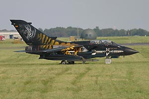
Images and information placed above are from http://www.fencecheck.com/forums/index.php?topic=582.0
We thank them for the data!
| General Info
|
| Country |
Germany
|
| ICAO ID |
ETNS
|
| Time |
UTC+1(+2DT)
|
| Latitude |
54.459333
54° 27' 33.60" N
|
| Longitude |
9.516333
009° 30' 58.80" E
|
| Elevation |
70 feet
21 meters
|
| Type |
Military
|
| Magnetic Variation |
000° E (01/05)
|
| Beacon |
Yes
|
| Operating Agency |
GERMAN AIR FORCE
|
| Alternate Name |
JAGEL
|
| Operating Hours |
SEE REMARKS FOR OPERATING HOURS OR COMMUNICATIONS FOR POSSIBLE HOURS
|
| Daylight Savings Time |
Last Sunday in March to last Sunday in October
|
| Communications
|
| TWR |
122.1
135.15
257.8
386.8
|
| RADAR APP |
123.3
142.05
135.15
139.65
269.05
|
| Runways
|
ID
|
Dimensions |
Surface |
PCN |
ILS
|
| 05/23 |
8003 x 98 feet
2439 x 30 meters |
ASPHALT |
- |
NO
|
07/25
CLOSED |
6554 x 148 feet
1998 x 45 meters |
ASPHALT |
- |
NO
|
| Navaids
|
| Type |
ID |
Name |
Channel |
Freq |
Distance From Field |
Bearing From Navaid
|
| TACAN |
SWG |
SCHLESWIG |
055X |
- |
At Field |
-
|
| Supplies/Equipment
|
| Fuel |
JP-8, SemiKeroscene MIL Spec T-83133, without icing inhibitor
100/130 octane gasoline, leaded, MIL-L-5572F (GREEN)
|
| Oil |
O-133, 1010, jet Engine Oil (MIL l 6081)
O-148, MIL L 7808 (Synthetic Base), Turboprop/Turboshaft Engine
|
| Other Fluids |
HPOX, High pressure oxygen servicing
LOX, Liquid oxygen servicing
|
| JASU |
RST-180
75kva AC 115/200v 400hz AIR 145-155lb/min at 47-51 psi
|
| Remarks
|
| FLUID |
HPOX LOX
|
| FUEL |
J8
|
| JASU |
1(GPE-160) 1(RST-180)
|
| MISC |
Fone C04624-30-0 extn 1822.
|
| OIL |
O-133-148
|
| OPR HOURS |
Opr 0700-1600Z++ Mon-Thu, 0700-1100Z++ Fri, clsd hol.
|
| RSTD |
AD 3 hr PPR, 96 hr PPR for trans acft. Practice apch proh fr 1130-1230Z++. Rwy 23: for non-homebased jet acft. Radar pat is mand. Clsd pat proh for non-homebased acft.
|
Runway 05/23
8003 x 98 feet
2439 x 30 meters
| Runway 05
|
| Surface |
ASPHALT
|
| True Heading |
047.0
|
| Latitude |
54.452000
54° 27' 07.20" N
|
| Longitude |
9.502500
009° 30' 09.00" E
|
| Elevation |
64.0 feet
20 meters
|
| Slope |
0.0°
|
| Landing Distance |
8003 feet
2439 meters
|
| Takeoff Distance |
9020 feet
2749 meters
|
| Overrun Length |
1017 feet
310 meters
|
| Overrun Surface |
CONCRETE.
|
| Lighting System |
SF
HIRL
J
PAPI |
| Runway 23
|
| Surface |
ASPHALT
|
| True Heading |
227.0
|
| Latitude |
54.466667
54° 28' 00.00" N
|
| Longitude |
9.530333
009° 31' 49.20" E
|
| Elevation |
64.0 feet
20 meters
|
| Slope |
0.0°
|
| Landing Distance |
8003 feet
2439 meters
|
| Takeoff Distance |
9092 feet
2771 meters
|
| Overrun Length |
1089 feet
332 meters
|
| Overrun Surface |
CONCRETE.
|
| Lighting System |
SF
HIRL
J
PAPI |
Navaids
| SCHLESWIG
|
| Type |
ID |
Channel |
Freq |
Country |
State
|
| TACAN |
SWG |
055X |
- |
Germany |
-
|
| Latitude |
Longitude |
Airport
|
54.453833
54° 27' 13.80" N |
9.501500
009° 30' 05.40" E |
ETNS |
The content above was published at Airports-Worldwide.com in 2005.
We don't guarantee the information is fresh and accurate. The data may be wrong or outdated.
For more up-to-date information please refer to other sources.
|
|

