 |
 |
|
||||
|
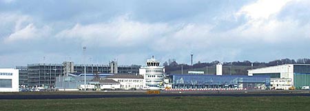
Lufthansa provided the first service with a scheduled flight from Frankfurt, while the French airline Compagnie Farmann flew in from Paris with its "Goliath". In May 1929 the Saarbrücken - Frankfurt connection was extended to include Berlin. And then in July 1929 the Budapest - Vienna - Munich - Karlsruhe - Saarbrücken - Paris route was opened, boosting air traffic in Saarbrücken, Köln and Düsseldorf even further. Until the winter of 1933/34 scheduled flights only operated in summer, i.e. from 1st May to 31st October, due to the technical limitations of both the aircraft and the airport facilities which were unable to cope with winter weather conditions. The history of Saarbrücken St Arnual came to an end on 28th August 1939 with the scheduled landing of the Lufthansa flight on the Cologne - Bonn route. Owing to the hazardous aerodynamic conditions experienced at St. Arnual Airport and continual runway closures due to poor weather, a circular area 800m in diameter, the so-called "ashtray", had been prepared in Saarbrücken Ensheim as a runway and a terminal constructed. The outbreak of war prevented this airport from commencing operations. As the state of Saarland was not initially integrated into the newly created Federal Republic of Germany in 1949, civil aviation stagnated in the immediate post-war period. After inital modest attempts at reconstructing Ensheim airfield, there was a decisive turn of events in 1964 when the state government declared its intention to construct an airport as part of a dedicated restructuring program, focusing among other things on the development of transportation facilities. It was designed with future aviation developments in mind, allowing it to accommodate both national and international medium-range flights. The technical modifications carried out between 1964 and 1973 in Ensheim meant that air traffic could be handled in an advanced manner, ensuring air traffic safety and passenger comfort. In 1972 Saarbrücken Airport was declared as the 11th International Airport in the FRG and in 1975 Lufthansa re-opened its facility in Ensheim, with scheduled flights to Frankfurt and Dusseldorf. Statistical records have been kept in Saarbrücken since 1969, when 19,346 and 5,529 passengers were recorded on scheduled and charter flights, respectively. On 13th July 1998 the 6 millionth air passenger was greeted in Saarbrücken. Today, the airport with its precision navigation equipment and its 2000m long and 45m wide runway, equipped with the latest beacons and guidance systems, is able to handle all medium-range air traffic. This means that all aeroplanes up to the Boeing 767, Airbus A310, Airbus 320, A300, A330, Tristar L1011, and Boeing 757 with a capacity of up to 330 passengers can take off and land effortlessly. In 1998, over 429,786 passengers passed through Saarbrücken Airport and the upward trend is continuing, with a first quarter increase of 8.5% in 1999. At the same time, conceptual and structural plans are already in place to ensure the future of Saarbrücken Airport.
Kategorie Int. Verkehrsflughafen / Int. Airport Zoll / Customs JA/YES Adresse Flughafen
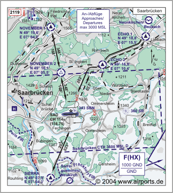
Images and information placed above are from http://www.flughafen-saarbruecken.de http://www.airports.de/airport.php?ICAO=EDDR We thank them for the data!
Runway 09/276562 x 148 feet
|
|||||||||||||||||||||||||||||||||||||||||||||||||||||||||||||||||||||||||||||||||||||||||||||||||||||||||||||||||||||||||||||||||||||||||||||||||||||||||||||||||||||||||||||||||||||||||||||||||||||||||||||||||||||||||||||||||||||||||||||||||||||||||||||||||
| Runway 09 | |
|---|---|
| Surface | ASPHALT |
| True Heading | 087.0 |
| Latitude | 49.214172 49° 12' 51.02" N |
| Longitude | 7.096681 007° 05' 48.05" E |
| Elevation | 1022.0 feet 312 meters |
| Slope | 0.5° |
| Landing Distance | 6476 feet 1974 meters |
| Takeoff Distance | 6562 feet 2000 meters |
| Displaced Threshold Length | 86 feet 26 meters |
| Lighting System | SF
CL HIRL REIL ODALS PAPI |
| Runway 27 | |
|---|---|
| Surface | ASPHALT |
| True Heading | 267.0 |
| Latitude | 49.214972 49° 12' 53.90" N |
| Longitude | 7.123725 007° 07' 25.41" E |
| Elevation | 1056.0 feet 322 meters |
| Slope | -0.5° |
| Landing Distance | 6562 feet 2000 meters |
| Takeoff Distance | 6648 feet 2026 meters |
| Overrun Length | 86 feet 26 meters |
| Overrun Surface | ASPHALT |
| Lighting System | SF
CL HIRL A1 PAPI |
| Runway 09L | |
|---|---|
| Surface | GRASS OR EARTH NOT GRADED OR ROLLED. |
| True Heading | 088.0 |
| Latitude | 49.215833 49° 12' 57.00" N |
| Longitude | 7.112222 007° 06' 44.00" E |
| Landing Distance | 1788 feet 545 meters |
| Takeoff Distance | 1788 feet 545 meters |
| Runway 27R | |
|---|---|
| Surface | GRASS OR EARTH NOT GRADED OR ROLLED. |
| True Heading | 268.0 |
| Latitude | 49.216031 49° 12' 57.71" N |
| Longitude | 7.119697 007° 07' 10.91" E |
| Landing Distance | 1788 feet 545 meters |
| Takeoff Distance | 1788 feet 545 meters |
| ENSHEIM | |||||
|---|---|---|---|---|---|
| Type | ID | Channel | Freq | Country | State |
| NDB | SR | - | 360 | Germany | - |
| Latitude | Longitude | Airport |
| 49.217769 49° 13' 03.97" N |
7.219511 007° 13' 10.24" E |
EDDR |
| SAARBRUCKEN | |||||
|---|---|---|---|---|---|
| Type | ID | Channel | Freq | Country | State |
| DME | SAD | 114Y | - | Germany | - |
| Latitude | Longitude | Airport |
| 49.212458 49° 12' 44.85" N |
7.116067 007° 06' 57.84" E |
EDDR |
The content above was published at Airports-Worldwide.com in 2005.
We don't guarantee the information is fresh and accurate. The data may be wrong or outdated.
For more up-to-date information please refer to other sources.

 |
|
Copyright 2004-2026 © by Airports-Worldwide.com, Vyshenskoho st. 36, Lviv 79010, Ukraine Legal Disclaimer |
 ICAO Code EDDR