 |
|
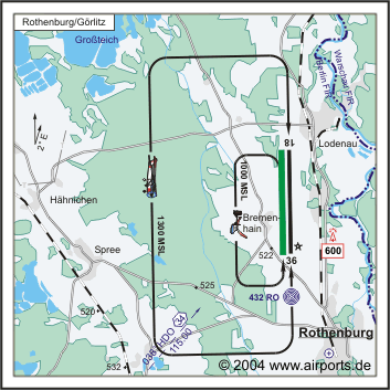
Rothenburg / Görlitz Airfield |
Ownerships: Ownership of the Administration Union Airfield
Rothenburg (communal)
Type of use: Industrial estate
Location and road links: Northern of the town Rothenburg
at the state street S 127 Görlitz – Bad Muskau, road link to
the major road B 115 via Neusorge (distance of 12 km), road link to the
motorway A 4 about 25 km; distance to the border crossing Podrosche (passenger
car) about 12 km; rail link to the goods station Horka about 8 km –
with own works siding,directly at the regional airfield with international
dispatch of goods (customs clearance station)
Planning, development and promotion: The airfield and
its flanking industrial estate are extended and developed step by step
and according to the demands.
There are valid customized prices for the “special disadvantaged
borderland” at the promotion area; additionally there can be used
different development programs of the EU for bilateral projects.
 ICAO Code EDBR
Name ROTHENBURG/GÖRLITZ
Land Deutschland
Bundesland Sachsen
Letzte Änderung 14. Oktober 2004
Kategorie Verkehrslandeplatz / Public Airfield
Betreiber / Operator Flugplatz Rothenburg/Görlitz GmbH
Lage / Location 2.7 NM N Rothenburg
LFZ / ACFT Bis / up to 14000 kg
Helicopter Ja / Yes
Motorsegler / GLDP Ja / Yes
Segelflugzeuge / GLD Ja / Yes
Ballone Ja / Yes
UL Ja / Yes
Fallschirmspringen / PJE Ja / Yes
Luftschiffe/Airships, Modellflugzeuge/Flying Models
Summer 0800-1800/SS+30
Winter 0900-1500
O/T PPR, 24 HR vorher, während der Betriebszeit/24 HR before, during
operation hours
Luftaufsicht / OPS +49 (0)35891 / 47100
PPR +49 (0)35891 / 47100
AIS EDDB +49 (0)30 / 60918250
MET (0190) 077226
Gafor 23
Zoll / Customs PPR 2HR vorher, während der Betriebszeit/ 2 HR before,
during operation hours
Fuel 100 LL, Jet A1
Oil D 100, 20W50
Hangar Beschränkt / Limited
Höhe / Elevation 517 ft / 158 m
FIS Berlin Information 125.800
VDF / QDM 123.250
Rufzeichen / Call sign Rothenburg Info
Frequenz Tower 123.250 GE
NAV Aids ABN 358°/0.6 NM from RO 432 039°/34 NM from HDO 115.00
Koordinaten 51 21, 79 N / 14 57, 00 E
Platzrunde / Traffic circuit W 1300
Landebahnen / RWY 2
RWY 2500 x 45 m, Asphalt
RWY 18 TKOF 2500 m; LDG 2500 m
RWY 36 TKOF 2500 m; LDG 2500 m
MTOW PCN 40 F/B/Y/T
RWY II 1220 x 40 m, Gras
RWY 18 TKOF 1220 m; LDG 1220 m
RWY 36 TKOF 1220 m; LDG 1220 m
MTOW RWY II 5700 kg
Bemerkungen / Remarks Rothenburg liegt innerhalb der Identifizierungszone.
Dafür gelten besondere Bestimmungengemäß ENR 3-5/aerodrom
is situated within the identification Zone The special regulations in
accordance with ENR 3-5 applay to this.
Restaurant Ja
Adresse
Friedensstr. 105 a
ZIP / City D-02929
Rothenburg
Fon +49 (0)35891 / 470
Fax 47205
Images and information placed above are from
http://www.airports.de/airport.php?ICAO=EDBR
We thank them for the data!
| General Info
|
| Country |
Germany
|
| ICAO ID |
EDBR
|
| Time |
UTC+1(+2DT)
|
| Latitude |
51.363167
51° 21' 47.40" N
|
| Longitude |
14.950000
014° 57' 00.00" E
|
| Elevation |
517 feet
158 meters
|
| Magnetic Variation |
002° E (01/05)
|
| Beacon |
Yes
|
| Operating Agency |
CIVIL GOVERNMENT, (LANDING FEES AND DIPLOMATIC CLEARANCE MAY BE REQUIRED)
|
| Operating Hours |
SEE REMARKS FOR OPERATING HOURS OR COMMUNICATIONS FOR POSSIBLE HOURS
|
| Daylight Savings Time |
Last Sunday in March to last Sunday in October
|
| Communications
|
| INFO |
123.25
|
| BERLIN INFO |
125.8
|
| Runways
|
ID
|
Dimensions |
Surface |
PCN |
ILS
|
| 18/36 |
8202 x 148 feet
2500 x 45 meters |
ASPHALT |
040FBYT |
NO
|
| 18R/36L |
4003 x 131 feet
1220 x 40 meters |
GRASS OR EARTH NOT GRADED OR ROLLED. |
- |
NO
|
| Navaids
|
| Type |
ID |
Name |
Channel |
Freq |
Distance From Field |
Bearing From Navaid
|
| NDB |
RO |
ROTHENBURG |
- |
432 |
1.2 NM |
354.0
|
| Supplies/Equipment
|
| Fuel |
Jet A1, without icing nhibitor.
100/130 MIL Spec, low lead, aviation gasoline (BLUE)
|
| Remarks
|
| CAUTION |
Gldr, ultralgt, model acft, balloon and PJE act.
|
| CSTMS/IMG |
CSTMS avbl PPR (2 hr PN, dur afld opr hr).
|
| FUEL |
(NC 100LL, A1)
|
| OPR HOURS |
Opr 0900-1500Z, O/T 24 hr PPR (0800-1800Z or SS+30, OT 24 hr PPR DT).
|
Runway 18/36
8202 x 148 feet
2500 x 45 meters
| Runway 18
|
| Surface |
ASPHALT
|
| True Heading |
179.0
|
| Latitude |
51.374400
51° 22' 27.84" N
|
| Longitude |
14.949786
014° 56' 59.23" E
|
| Landing Distance |
8202 feet
2500 meters
|
| Takeoff Distance |
8202 feet
2500 meters
|
| Lighting System |
S
LIGHTS |
| Runway 36
|
| Surface |
ASPHALT
|
| True Heading |
359.0
|
| Latitude |
51.351933
51° 21' 06.96" N
|
| Longitude |
14.950214
014° 57' 00.77" E
|
| Landing Distance |
8202 feet
2500 meters
|
| Takeoff Distance |
8202 feet
2500 meters
|
| Lighting System |
S
LIGHTS |
Runway 18R/36L
4003 x 131 feet
1220 x 40 meters
| Runway 18R
|
| Surface |
GRASS OR EARTH NOT GRADED OR ROLLED.
|
| True Heading |
178.0
|
| Latitude |
0.000000
-
|
| Longitude |
0.000000
-
|
| Landing Distance |
4003 feet
1220 meters
|
| Takeoff Distance |
4003 feet
1220 meters
|
| Runway 36L
|
| Surface |
GRASS OR EARTH NOT GRADED OR ROLLED.
|
| True Heading |
358.0
|
| Latitude |
0.000000
-
|
| Longitude |
0.000000
-
|
| Landing Distance |
4003 feet
1220 meters
|
| Takeoff Distance |
4003 feet
1220 meters
|
Navaids
| ROTHENBURG
|
| Type |
ID |
Channel |
Freq |
Country |
State
|
| NDB |
RO |
- |
432 |
Germany |
-
|
| Latitude |
Longitude |
Airport
|
51.343625
51° 20' 37.05" N |
14.952033
014° 57' 07.32" E |
EDBR |
The content above was published at Airports-Worldwide.com in 2005.
We don't guarantee the information is fresh and accurate. The data may be wrong or outdated.
For more up-to-date information please refer to other sources.
|
|


