 |
|
Niederrhein (Weeze) Airport |
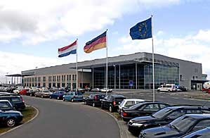 Airport Weeze is located in the geographical centre of Western Europe
on the borders of the Netherlands and Belgium.
Airport Weeze is located in the geographical centre of Western Europe
on the borders of the Netherlands and Belgium.
The advantage of this airport is its unique location in the centre of
the Rhine, Ruhrgebiet and the Netherlands. Economic areas such as Düsseldorf,
Essen, Duisburg, Krefeld, Mönchengladbach, Eindhoven, Nimwegen, Arnheim
and Venlo lie in a radius of 80 km. The distance to Cologne and Dortmund
is 100 km, and 115 km to Maastricht. There are motorway links 12 km away,
on the German side and the Dutch side.
History of Airport Weeze
1954
Founding of the British military airport Weeze/Laarbruch. The Royal Air
Force stations Tornados, Bucaneers and Harriers among other planes. The
British are very active at all levels of society and are very well-liked
as neighbours in the Niederrhein. Many friendly relationships still exist
today.
1993
Founding of "Flughafen Niederrhein GmbH". The region is the
responsible body. The company works out use concepts for the airport area.
The aim: new jobs and the attracting of companies, to balance out the
predicted departure of 5,000 members of the armed forces.
1997
The use concept "Euro-regional Centre For Air Traffic, Logistics
And Trade" meets with broad agreement in the Netherlands and in Germany
. The approval procedure begins.
1999
After 45 years, the Royal Air Force leaves its Weeze/Laarbruch base, on
the 30th November. The region loses good friends, who are also appreciated
as clients and customers. Over 400 civilian jobs are lost.
2001
A Dutch group of investors purchases Laarbruch and takes over the 620
ha area. On the 20th June, Transport Minister Ernst Schwanhold grants
the aviation law approval for civilian air traffic.
2002
The construction of the new passenger terminal and of a new apron begins.
The air traffic facilities are completely renovated and partially replaced.
German Air Traffic Control sets up a tower.
2003
On the 1st of May, the new Airport Niederrhein starts regular service.
The low-cost airline Ryanair flies 3 times daily to London.
Until the 1st August, the passengers are checked in in a provisionally
converted hangar. The new 15,000 m2 terminal is opened.
In October, the airport receives its first Homecarrier: the Dutch V Bird
stations three Airbus A 320s and offers low-cost German and European flights.
A complaint from the neighbouring borough of Bergen leads to a restriction
of weekend flights. Flight diversions and the transportation of the passengers
to remote alternative airports cost the young airline over a million Euro.
The Dutch operator Sudtours only runs flights for a short time with its
holiday plane Dutchbird; the marketing of package tours to Gran Canaria
in Germany remains unsuccessful.
2004
On the 1st of May - weekend, 80,000 visitors celebrate the airport's first
birthday. Soon after, the 500,000th passeger is welcomed.
The airport extends the parking areas: 3,000 parking spaces are now available.
On the 8th October, V Bird ceases trading, negotiations with new investors
having surprisingly failed. Shortly afterwards, the company files for
bankruptcy. Around 4,000 V Bird passengers must look for new tickets.
As a result, around 100 employees lose their job at the airport.
Ryanair extends its range of flights to the Niederrhein. Ryanair currently
offers daily flights to London/Stansted, Glasgow/Prestwick, Barcelona/Girona,
Rome/Ciampino and Stockholm/Skavsta. Charter flights to Antalya are available
with atlasjet, Sky Airways and MNG.
 ICAO
Code EDLV ICAO
Code EDLV
Name NIEDERRHEIN
Land Deutschland
Bundesland Nordrhein-Westfalen
Letzte Änderung 31. März 2005
Kategorie Verkehrsflughafen / Airport
Betreiber / Operator Flughafen Niederrhein GmbH
Lage / Location 2 NM SW Weeze
Instrumentenflug / IFR Ja / Yes
LFZ / ACFT Bis / up to PCN 45 R(F)B/W/T,
Helicopter Ja / Yes
Motorsegler / GLDP Ja / Yes
Segelflugzeuge / GLD nein / n
Ballone Ja / Yes
UL nein / n
Flugbetrieb mit Jets nach VFR ist unzulässig / VFR flight operations
with jet aircraft are not permitted
IFR:
Summer 0300 - 2200Z, departures to and arrivals from the Dutch side 0400
-2100Z, CTR H 24
Winter 0400 - 2300Z, departures to and arrivals from the Dutch side 0500
-2200Z, CTR H 24
VFR:
Summer 0400 - 2000Z, CTR H 24
Winter 0500 - 2100Z, CTR H 24.
For further restrictions consult AIP.
O/T PPR
OPS +49 (0)2837 / 666600, Fax +49 (02837) 666617
PPR +49 (0)2837 / 666600
Luftaufsicht +49 (0)2837 / 666620
AIS AIS-Centre EDDZ, +49 (0)69 / 78072500
ACC EDDL +49 (0)6103 / 7076600 / 6601
MET 0190 077223
Gafor 31
Zoll / Customs 0400 -2300 (0300 -2200)
Fuel 100 LL, Jet A1
Oil D 80, D 100, kein/no Carnet
Hangar O/R
Höhe / Elevation 106 ft / 32 m
FIS Langen Information 129.875, Niederrhein ATIS 124.450
Rufzeichen / Call sign Niederrhein Tower/Turm
Frequenz Tower 129.400 En/Ge
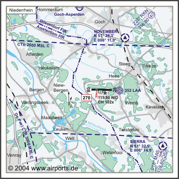
NAV Aids ABN NDB LAA 352 DME "NID" 115.50, ILS 27 110.700
Koordinaten 51 36,14 N / 06 08,53 E
Landebahnen / RWY 1
RWY 2440 x 45 m, Concrete/Asphalt
RWY 09 TKOF 2440 m; LDG 2440 m
RWY 27 TKOF 2440 m; LDG 2440 m
MTOW PCN 45R (F)/B/W/T
Restaurant Ja
Adresse
Flughafen-Ring 60
ZIP / City D-47657 Weeze
Fon +49 (0)2837 / 666600
Fax 666618
URL http://www.airport-niederrhein.de
eMail edlvops at airport-niederrhein de
Images and information placed
above are from http://www.airports.de/airport.php?ICAO=EDLV
http://www.airport-niederrhein.de
We thank them for the data!
| General Info
|
| Country |
Germany
|
| ICAO ID |
EDLV
|
| Time |
UTC+1(+2DT)
|
| Latitude |
51.602414
51° 36' 08.69" N
|
| Longitude |
6.142172
006° 08' 31.82" E
|
| Elevation |
106 feet
32 meters
|
| Type |
Civil
|
| Magnetic Variation |
000° W (01/05)
|
| Beacon |
Yes
|
| Operating Agency |
CIVIL GOVERNMENT, (LANDING FEES AND DIPLOMATIC CLEARANCE MAY BE REQUIRED)
|
| Alternate Name |
LAARBRUCH
|
| Operating Hours |
SEE REMARKS FOR OPERATING HOURS OR COMMUNICATIONS FOR POSSIBLE HOURS
|
| Daylight Savings Time |
Last Sunday in March to last Sunday in October
|
| Communications
|
| TWR |
129.4
|
| LANGEN RADAR |
128.5
277.35
|
| LANGEN INFO |
129.875
|
ATIS
Opr 0320-2250Z++.
|
124.45
|
| Runways
|
ID
|
Dimensions |
Surface |
PCN |
ILS
|
| 09/27 |
8005 x 148 feet
2440 x 45 meters |
PART CONCRETE, PART ASPHALT, OR PART BITUMEN-BOUND MACADAM. |
045RBWT |
YES
|
| Navaids
|
| Type |
ID |
Name |
Channel |
Freq |
Distance From Field |
Bearing From Navaid
|
| DME |
NID |
NIEDERRHEIN |
102X |
- |
At Field |
-
|
| Supplies/Equipment
|
| Fuel |
Jet A1, without icing nhibitor.
100/130 MIL Spec, low lead, aviation gasoline (BLUE)
|
| Remarks
|
| CAUTION |
Extv gldr act.
|
| CSTMS/IMG |
CSTMS avbl O/R. IMG avbl 0630-2130Z++ Mon-Fri, 0700-1800Z++ Sat, 1130-2215Z++ Sun, OT PPR 24 hr PN.
|
| FLUID |
De-Ice (unavbl til 31 Dec 03).
|
| FUEL |
(NC-100LL, A1)
|
| RSTD |
Acft up to and incl ICAO Code C and B757 permitted til 31 Dec 04.
|
Runway 09/27
8005 x 148 feet
2440 x 45 meters
| Runway 09
|
| Surface |
PART CONCRETE, PART ASPHALT, OR PART BITUMEN-BOUND MACADAM.
|
| True Heading |
092.0
|
| Latitude |
51.602844
51° 36' 10.24" N
|
| Longitude |
6.124536
006° 07' 28.33" E
|
| Elevation |
95.0 feet
29 meters
|
| Slope |
0.1°
|
| Landing Distance |
8005 feet
2440 meters
|
| Takeoff Distance |
8907 feet
2715 meters
|
| Overrun Length |
902 feet
275 meters
|
| Overrun Surface |
ASPHALT
|
| Lighting System |
HIRL
Q
PAPI |
| Runway 27
|
| Surface |
PART CONCRETE, PART ASPHALT, OR PART BITUMEN-BOUND MACADAM.
|
| True Heading |
272.0
|
| Latitude |
51.602022
51° 36' 07.28" N
|
| Longitude |
6.159728
006° 09' 35.02" E
|
| Elevation |
105.0 feet
32 meters
|
| Slope |
-0.1°
|
| Landing Distance |
8005 feet
2440 meters
|
| Takeoff Distance |
8907 feet
2715 meters
|
| Overrun Length |
902 feet
275 meters
|
| Overrun Surface |
ASPHALT
|
| Lighting System |
HIRL
Q
PAPI |
Navaids
| NIEDERRHEIN
|
| Type |
ID |
Channel |
Freq |
Country |
State
|
| DME |
NID |
102X |
- |
Germany |
-
|
| Latitude |
Longitude |
Airport
|
51.599967
51° 35' 59.88" N |
6.141481
006° 08' 29.33" E |
EDLV |
The content above was published at Airports-Worldwide.com in 2005.
We don't guarantee the information is fresh and accurate. The data may be wrong or outdated.
For more up-to-date information please refer to other sources.
|
|


