|
ICAO Code EDBK
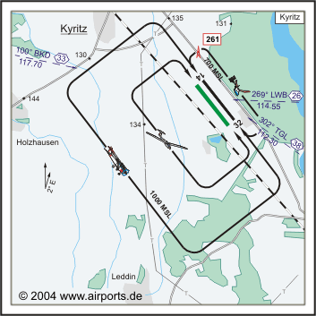
Name KYRITZ
Land Deutschland
Bundesland Brandenburg
Letzte Änderung 14. Oktober 2004
Kategorie Verkehrslandeplatz / Public Airfield
Betreiber / Operator Stadt Kyritz
Lage / Location 2 NM SE Kyritz
LFZ / ACFT Bis / up to 5700 kg,
Helicopter Ja / Yes
Motorsegler / GLDP Ja / Yes
Segelflugzeuge / GLD Ja / Yes
Ballone Ja / Yes
UL Ja / Yes
Fallschirmspringen / PJE Ja / Yes
H-GLD, Luftschiffe/Airships
Summer 0700-1700
Winter 0800-SS+30
O/T PPR
Luftaufsicht / OPS +49 (0)33971 / 52237, Fax 60790
AIS EDDB +49 (0)30 / 60918250
MET (0190) 077222
Gafor 13
Zoll / Customs PPR
Fuel 100 LL, Jet A1
Oil 100, W 100
Hangar O / R
Höhe / Elevation 130 ft / 40 m
FIS Berlin Information 126.350
VDF / QDM 122.725
Rufzeichen / Call sign Kyritz Info
Frequenz Tower 122.725 GE
NAV Aids ABN 101°/33 NM from BKD VOR/DME 117.70/Ch 124 304°/38
NM from TGL DVOR/DME 112.30/Ch 70
Koordinaten 52 55, 13 N / 12 25, 52 E
Platzrunde / Traffic circuit SW 1000
Landebahnen / RWY 2
RWY 1000 x 23 m, BITUMEN
RWY 14 TKOF 1000 m; LDG 1000 m
RWY 32 TKOF 1000 m; LDG 1000 m
MTOW 5700 kg
RWY II 1000 x 30 m, Gras
RWY 14 TKOF 1000 m; LDG 1000 m
RWY 32 TKOF 1000 m; LDG 1000 m
MTOW RWY II 2000 kg
Bemerkungen / Remarks GLD + PJE! Wohngebiete und Seengebiet meiden! UL-Betrieb
Adresse
Adresse Marktplatz 1
ZIP / City D-16866
Kyritz
Fon +49 (0)33971 / 85265
Fax 85285
URL http://www.airports.de/airport.php?ICAO=EDBK
Images and information placed above are from http://www.airports.de/airport.php?ICAO=EDBK
We thank them for the data!
| General Info
|
| Country |
Germany
|
| ICAO ID |
EDBK
|
| Time |
UTC+1(+2DT)
|
| Latitude |
52.918833
52° 55' 07.80" N
|
| Longitude |
12.425333
012° 25' 31.20" E
|
| Elevation |
130 feet
40 meters
|
| Type |
Civil
|
| Magnetic Variation |
001° E (01/05)
|
| Beacon |
Yes
|
| Operating Agency |
CIVIL GOVERNMENT, (LANDING FEES AND DIPLOMATIC CLEARANCE MAY BE REQUIRED)
|
| Operating Hours |
SEE REMARKS FOR OPERATING HOURS OR COMMUNICATIONS FOR POSSIBLE HOURS
|
| Daylight Savings Time |
Last Sunday in March to last Sunday in October
|
| Communications
|
| INFO |
122.725
|
| BERLIN INFO |
126.35
|
| Runways
|
ID
|
Dimensions |
Surface |
PCN |
ILS
|
| 14/32 |
3281 x 75 feet
1000 x 23 meters |
ASPHALT |
- |
NO
|
| 14R/32L |
3281 x 98 feet
1000 x 30 meters |
GRASS OR EARTH NOT GRADED OR ROLLED. |
- |
NO
|
| Remarks
|
| FUEL |
(NC 100LL, A1)
|
| LGT |
PAPI Rwy 14-32 GS 3.5 .
|
| OPR HOURS |
Opr 0800Z-SS+30 (0700-1700Z sum); OT O/R.
|
Runway 14/32
3281 x 75 feet
1000 x 23 meters
| Runway 14
|
| Surface |
ASPHALT
|
| True Heading |
140.6
|
| Latitude |
52.922306
52° 55' 20.30" N
|
| Longitude |
12.420617
012° 25' 14.22" E
|
| Landing Distance |
3281 feet
1000 meters
|
| Takeoff Distance |
3281 feet
1000 meters
|
| Lighting System |
MIRL
PAPI |
| Runway 32
|
| Surface |
ASPHALT
|
| True Heading |
320.6
|
| Latitude |
52.915361
52° 54' 55.30" N
|
| Longitude |
12.430047
012° 25' 48.17" E
|
| Landing Distance |
3281 feet
1000 meters
|
| Takeoff Distance |
3281 feet
1000 meters
|
| Lighting System |
MIRL
PAPI |
Runway 14R/32L
3281 x 98 feet
1000 x 30 meters
| Runway 14R
|
| Surface |
GRASS OR EARTH NOT GRADED OR ROLLED.
|
| True Heading |
141.0
|
| Latitude |
52.921964
52° 55' 19.07" N
|
| Longitude |
12.419928
012° 25' 11.74" E
|
| Landing Distance |
3281 feet
1000 meters
|
| Takeoff Distance |
3281 feet
1000 meters
|
| Runway 32L
|
| Surface |
GRASS OR EARTH NOT GRADED OR ROLLED.
|
| True Heading |
321.0
|
| Latitude |
52.915017
52° 54' 54.06" N
|
| Longitude |
12.429358
012° 25' 45.69" E
|
| Landing Distance |
3281 feet
1000 meters
|
| Takeoff Distance |
3281 feet
1000 meters
|
The content above was published at Airports-Worldwide.com in 2005.
We don't guarantee the information is fresh and accurate. The data may be wrong or outdated.
For more up-to-date information please refer to other sources.
|


