 |
|
 HISTORY
1938 - The German Airforce establishes a military airfield at a former
artillery shooting range in the Wahner Heide.
The airfield is enlarged by the occupying powers, a takeoff runway with
a length of 1,866 m, a control tower and a number of hangars are built.
1949 - First discussions on a commercial airport to give Bonn, which
had just become the provisional German capital, the business city of Cologne
and the greater Cologne/Bonn area international air links.
1950 - The Civil Aviation Board, British Element gives the cities of
Cologne and Bonn a licence to use the facilities of Wahn Airport for a
one-year period. Cologne and Bonn transfer exercise of their rights and
duties to a private limited company named "K?ln-Bonner Flughafen
Wahn GmbH zu Porz" formed in 1950.
The initial shareholders are the Federal Republic of Germany, the Federal
State of North-Rhine-Westphalia, the city of Cologne, the city of Bonn,
the Sieg district, and the town of Porz. Rheinisch-Bergisch district became
a further shareholder. The airport's first director was Prof. Dr.-Ing.
Heinrich Steinmann (until 1964). The airport's manager begins preparatory
work in October 1950. Flights begin in September. BEA flies to Berlin
for the first time (23 September).
1960 - he fiscal year is changed: now the calendar year. Topping-out
ceremony for the extended runway (14 October).
Extension of the terminal buildings.
Finnair uses Caravelles for the first time (Copenhagen-Helsinki as of
1 April).
Swissair flies DC 8s to New York for the first time (as of 1 April).
1970 - The German President, Gustav Heinemann, opens the new terminal
on 20 March.
The fuelling service plant becomes operational on 1 July.
Topping-out ceremony for the cargo centre on 17 September.
Completion of the ITS building in October.
Lufthansa begins a daily jumbo-jet service to New York on 1 November.
Jumbo christening of the "Nordrhein-Westfalen" by Minister President
K?hn and his wife.
1980 - Difficult international economic situation, decline in demand.
Open day on 18 May.
Pope John Paul II lands at Cologne/Bonn on 15 November.
1990 - Extension of areas A and D of the terminal.
Lufthansa starts scheduled flights from Cologne/Bonn to New York-Newark
and the airport again has regular connections to the USA.
The number of passengers exceeds the 3-million mark for the first time.
A central issue: priority given to environmental compatibility.
Decision to pay voluntary subsidies to finance passive noise barriers.
2000 - Demolition of the old tower in spring. Extension of passive noise
prevention. First "Ramp Safety Information Exchange" in March
is very well received.
The new Stockheim in-flight catering facility on Nordallee goes into service
(March).
2003 - Joint reception given by D?sseldorf Airport and Cologne/Bonn Airport
at the ITB in Berlin (10 March). Burger King opens a fast-food restaurant
(28 March).
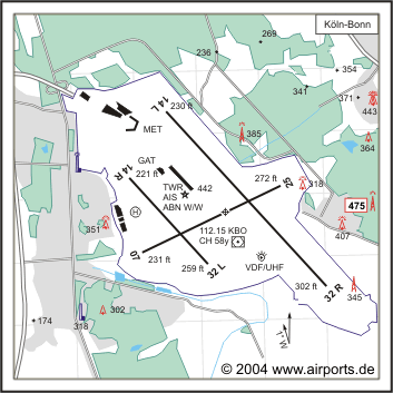
 ICAO Code EDDK
IATA Code CGN
Name KÖLN - Bonn
Land Deutschland
Bundesland Nordrhein-Westfalen
Letzte Änderung 9. April 2004
Kategorie Int. Verkehrsflughafen / Int. Airport
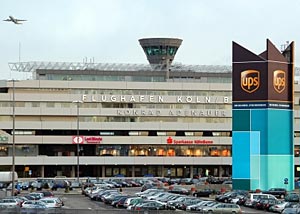
Betreiber / Operator Flughafen Köln/Bonn GmbH
Lage / Location 8 NM SE Stadtmitte/Centre Köln
Nachtflug / NVFR NVFR
Instrumentenflug / IFR IFR
LFZ / ACFT Bis / up to PCN 75 F/B/W/T
Helicopter Ja / Yes
Motorsegler / GLDP Ja / Yes
Siehe/See AIP VFR AD2-57
Summer H 24, CTR H 24
Winter H 24, CTR H 24
AIS EDDK +49 (0)2203 / 5707134
APP EDDL +49 (0)211 / 4154239
MET (0190) 077223
Gafor 34
 Zoll / Customs H 24
Fuel 100 LL, Jet A1
Oil 80, 100, D 80, D 100, 15 W 50
Hangar Ja / Yes
Höhe / Elevation 302 ft / 92 m
FIS Langen Information 129.875
VDF / QDM O/R
Rufzeichen / Call sign Köln-Bonn Tower/Turm
Frequenz Tower 124.975 EN/GE
Frequenz Ground 121.725 EN/GE
NAV Aids ABN PAPI KBO 112.15 am Platz/at field ILS RWY 32R 109.70 ILS
RWY 25 109.10 ILS RWY 14L 110.90
Koordinaten 50 51, 95 N / 07 08, 56 E
Landebahnen / RWY 1
RWY 3815 x 60 m, ASPHALT
RWY 14L TKOF 3815 m; LDG 3815 m
RWY 32R TKOF 3815 m; LDG 3815 m
MTOW 75 F/B/W/T
RWY II 1863 x 45 m, CONCRETE
RWY 14R TKOF 1863 m; LDG 1863 m
RWY 32L TKOF 1863 m; LDG 1863 m
MTOW RWY II 37 F/B/W/T
RWY III 2459 x 45 m, CONCRETE
RWY 07 TKOF 2459 m; LDG 2459 m
RWY 25 TKOF 2459 m; LDG 2459 m
MTOW RWY III 49 R/B/W/T
Restaurant - Yes
Adresse
Postfach 980120
ZIP / City D-51129
Köln
Fon +49 (0)2203 / 400
Fax +49 (0)22 03 - 40 27 02
URL http://www.airport-cgn.de
Images and information placed above are from http://www.airports.de/airport.php?ICAO=EDDK
http://www.airport-cgn.de
We thank them for the data!
| General Info
|
| Country |
Germany
|
| ICAO ID |
EDDK
|
| Time |
UTC+1(+2DT)
|
| Latitude |
50.865917
50° 51' 57.30" N
|
| Longitude |
7.142744
007° 08' 33.88" E
|
| Elevation |
302 feet
92 meters
|
| Type |
Joint (Civil and Military)
|
| Magnetic Variation |
000° E (01/05)
|
| Beacon |
Yes
|
| Operating Agency |
MILITARY - CIVIL JOINT USE AIRPORT
|
| Alternate Name |
COLOGNE OR WAHN
|
| Near City |
Cologne
|
| Operating Hours |
24 HOUR OPERATIONS
|
| International Clearance Status |
Airport of Entry
|
| Daylight Savings Time |
Last Sunday in March to last Sunday in October
|
| Communications
|
| TWR |
124.975
291.2
|
| LANGEN RADAR |
118.75
126.325
291.65
298.55
|
| MIL |
136.25
312.1
Call 15 min prior to ldg is mand for acft using Koln/Bonn mil site.
|
| APRON |
121.95
300.25
|
| LANGEN INFO |
129.875
|
| GND |
121.725
|
| DIR |
121.05
292.55
|
| CLNC DEL |
121.85
|
| ATIS |
112.15
119.025
122.1
122.1 (Mil acft only)
|
| Runways
|
ID
|
Dimensions |
Surface |
PCN |
ILS
|
| 07/25 |
8067 x 148 feet
2459 x 45 meters |
CONCRETE. |
049RBWT |
YES
|
| 14R/32L |
6112 x 148 feet
1863 x 45 meters |
ASPHALT |
037FBWT |
NO
|
| 14L/32R |
12516 x 197 feet
3815 x 60 meters |
ASPHALT |
075FBWT |
YES
|
| Navaids
|
| Type |
ID |
Name |
Channel |
Freq |
Distance From Field |
Bearing From Navaid
|
| VORTAC |
COL |
COLA |
025X |
108.8 |
17.9 NM |
286.2
|
| VOR-DME |
KBO |
KOLN/BONN |
058Y |
112.15 |
At Field |
-
|
| NDB |
LW |
KOLN/BONN |
- |
300.5 |
4.6 NM |
245.5
|
| Supplies/Equipment
|
| Fuel |
Jet A1+, Jet A1 with icing inhibitor.
Jet A1, without icing nhibitor.
JP-8, SemiKeroscene MIL Spec T-83133, without icing inhibitor
100/130 MIL Spec, low lead, aviation gasoline (BLUE)
|
| Oil |
O-123, 1065,(Dispersant)Reciprocating Engine Oil(MIL L 22851 Type III)
O-133, 1010, jet Engine Oil (MIL l 6081)
O-148, MIL L 7808 (Synthetic Base), Turboprop/Turboshaft Engine
O-156, MIL L 23699 (Synthetic Base)Turboprop/Turboshaft Engine
|
| Other Fluids |
LHOX, Low and high pressure oxygen servicing
OX, Indicates oxygen servicing when type of servicing is unknown
|
| JASU |
RST-180
75kva AC 115/200v 400hz AIR 145-155lb/min at 47-51 psi
|
| Remarks
|
| CAUTION |
Lgt pole aprx 55' hi on S end of mil ramp.
|
| FLUID |
LHOX
|
| FUEL |
Avbl 0400-2400Z++, OT O/R (NC- 100LL, A1) fone C(02203)-4001/4002.
|
| JASU |
9(G-40) 3(GSU-160) 1(RST-180)
|
| LGT |
PAPI Rwy 14L MEHT 63', Rwy 32R MEHT 63', Rwy 25 MEHT 57', Rwy 32L MEHT 42'.
|
| OIL |
O-123-133-148-156
|
| RSTD |
Strictly 24 hr PPR Mon-Fri; 48 hr PPR Sat, Sun and hol. PPR also for ISAF/Enduring Freedom flts. PPR only via AFTN (ETNKZPZX) or fax C02203 9086737. PPR-Nr mustbe incl in Item 18 of FPL. For flt to the mil part of Koln/Bonn, address FPL toETCCZQZX. Acft using Koln/Bonn mil site have to ctc Koln/Bonn mil addn on 312.1or 136.25 15 min prior to ldg and pass ETA and POB on same freq. Gnd svc by GAFavbl 0600-1900Z++ Mon-Fri, OT O/R via fone C02203-908-3267. Ldg with armed acft proh. Use of Rwy 25 for tkof and Rwy 07 for tkof and ldg by combat acft is only permitted if Rwy 14L-32R not avbl due to const or acft malfunction. Rwy 32L TODA 5226' due WIP.
|
| TRAN ALERT |
Mil tran acft prk area S of thld Rwy 07.
|
Runway 07/25
8067 x 148 feet
2459 x 45 meters
| Runway 07
|
| Surface |
CONCRETE.
|
| True Heading |
064.0
|
| Latitude |
50.860122
50° 51' 36.44" N
|
| Longitude |
7.123778
007° 07' 25.60" E
|
| Elevation |
231.0 feet
70 meters
|
| Slope |
0.5°
|
| Landing Distance |
8067 feet
2459 meters
|
| Takeoff Distance |
8264 feet
2519 meters
|
| Overrun Length |
197 feet
60 meters
|
| Overrun Surface |
ASPHALT
|
| Lighting System |
CL
HIRL
T
PAPI |
| Runway 25
|
| Surface |
CONCRETE.
|
| True Heading |
244.0
|
| Latitude |
50.869669
50° 52' 10.81" N
|
| Longitude |
7.155272
007° 09' 18.98" E
|
| Elevation |
272.0 feet
83 meters
|
| Slope |
-0.5°
|
| Landing Distance |
8067 feet
2459 meters
|
| Takeoff Distance |
8264 feet
2519 meters
|
| Overrun Length |
197 feet
60 meters
|
| Overrun Surface |
ASPHALT
|
| Lighting System |
SF
CL
HIRL
REIL
T
PAPI |
Runway 14R/32L
6112 x 148 feet
1863 x 45 meters
| Runway 14R
|
| Surface |
ASPHALT
|
| True Heading |
138.0
|
| Latitude |
50.870844
50° 52' 15.04" N
|
| Longitude |
7.120861
007° 07' 15.10" E
|
| Elevation |
221.0 feet
67 meters
|
| Slope |
0.6°
|
| Landing Distance |
6112 feet
1863 meters
|
| Takeoff Distance |
6309 feet
1923 meters
|
| Overrun Length |
197 feet
60 meters
|
| Overrun Surface |
ASPHALT
|
| Lighting System |
CL
HIRL
T
PAPI |
| Runway 32L
|
| Surface |
ASPHALT
|
| True Heading |
318.0
|
| Latitude |
50.858506
50° 51' 30.62" N
|
| Longitude |
7.138742
007° 08' 19.47" E
|
| Elevation |
259.0 feet
79 meters
|
| Slope |
-0.6°
|
| Landing Distance |
6112 feet
1863 meters
|
| Takeoff Distance |
6309 feet
1923 meters
|
| Overrun Length |
197 feet
60 meters
|
| Overrun Surface |
ASPHALT
|
| Lighting System |
CL
HIRL
T
PAPI |
Runway 14L/32R
12516 x 197 feet
3815 x 60 meters
| Runway 14L
|
| Surface |
ASPHALT
|
| True Heading |
137.0
|
| Latitude |
50.880469
50° 52' 49.69" N
|
| Longitude |
7.129075
007° 07' 44.67" E
|
| Elevation |
230.0 feet
70 meters
|
| Slope |
0.6°
|
| Landing Distance |
12516 feet
3815 meters
|
| Takeoff Distance |
12713 feet
3875 meters
|
| Overrun Length |
197 feet
60 meters
|
| Overrun Surface |
ASPHALT
|
| Lighting System |
SF
TDZL
CL
HIRL
REIL
A1
PAPI |
| Runway 32R
|
| Surface |
ASPHALT
|
| True Heading |
317.0
|
| Latitude |
50.855194
50° 51' 18.70" N
|
| Longitude |
7.165692
007° 09' 56.49" E
|
| Elevation |
302.0 feet
92 meters
|
| Slope |
-0.6°
|
| Landing Distance |
12516 feet
3815 meters
|
| Takeoff Distance |
12713 feet
3875 meters
|
| Overrun Length |
197 feet
60 meters
|
| Overrun Surface |
ASPHALT
|
| Lighting System |
SF
TDZL
CL
HIRL
REIL
A
PAPI |
Navaids
| COLA
|
| Type |
ID |
Channel |
Freq |
Country |
State
|
| VORTAC |
COL |
025X |
108.8 |
Germany |
-
|
| Latitude |
Longitude |
Airport
|
50.783519
50° 47' 00.67" N |
7.594194
007° 35' 39.10" E |
EDDK |
Navaids
| KOLN/BONN
|
| Type |
ID |
Channel |
Freq |
Country |
State
|
| VOR-DME |
KBO |
058Y |
112.15 |
Germany |
-
|
| Latitude |
Longitude |
Airport
|
50.861678
50° 51' 42.04" N |
7.145517
007° 08' 43.86" E |
EDDK |
Navaids
| KOLN/BONN
|
| Type |
ID |
Channel |
Freq |
Country |
State
|
| NDB |
LW |
- |
300.5 |
Germany |
-
|
| Latitude |
Longitude |
Airport
|
50.898306
50° 53' 53.90" N |
7.252850
007° 15' 10.26" E |
EDDK |
The content above was published at Airports-Worldwide.com in 2005.
We don't guarantee the information is fresh and accurate. The data may be wrong or outdated.
For more up-to-date information please refer to other sources.
|
|


