 |
|
Husum
(Schwesing) Airfield |
 Used by RAF until 1946.
German Airforce until early 1990s.
Civil operations since 2000.
ICAO Code EDXJ
Name HUSUM - Schwesing
Land Deutschland
Bundesland Schleswig-Holstein
Letzte Änderung 15. September 2004
Kategorie Verkehrslandeplatz / Public Airfield
Betreiber / Operator Flughafen Husum GmbH & Co. KG
Lage / Location 3.8 NM NE Husum
Nachtflug / NVFR NVFR PPR
LFZ / ACFT Bis / up to 5700 kg 14000 kg am Tage/at day PPR, HEL 10000
kg
Helicopter Ja / Yes
Motorsegler / GLDP Ja / Yes
Segelflugzeuge / GLD Ja / Yes
Ballone Ja / Yes
UL Ja / Yes
Fallschirmspringen / PJE Ja / Yes
Luftschiffe/airships, UL mit Funk PPR
Summer 0800 - 1800/SS+30
Winter PPR
O/T PPR
Luftaufsicht / OPS +49 (0)4841 / 96660, 74256, +49 (0)4846 / 6606, Fax
966650
PPR +49 (0)4841 / 2560, 64574, +49 (0)4846 / 550
AIS AIS-Centre +49 (0)69 / 78072500
ACC EDDW +49 (0)421 / 5372120
MET (0190) 077221
Gafor 3
Zoll / Customs 24 HR PPR
Fuel 100 LL , JetA1, Super Plus
Oil 15 W 50, D100, D80
Hangar Beschränkt / Limited
Höhe / Elevation 62 ft / 19 m
FIS Bremen Information 125.100
Rufzeichen / Call sign Husum Info
Frequenz Tower 122.050 GE
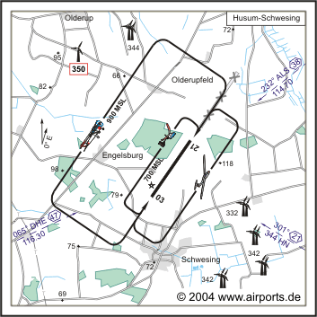
NAV Aids 065°/47 NM from DHE 116.30 232°/38 NM from ALS 114.70
301°/21 NM from HN 344
Koordinaten 54 30, 60 N / 09 08, 30 E
Platzrunde / Traffic circuit NW 900
Landebahnen / RWY 1
RWY 1450 x 30 m, ASPHALT
RWY 03 TKOF 1140 m; LDG 1140 m
RWY 21 TKOF 1140 m; LDG 1140 m
MTOW 5700 kg, PPR 14000 kg
Adresse
Am Flugplatz 1
ZIP / City D-25813 Husum
Fon +49 (0)4841 / 1490
Fax 1490
URL http://www.flughafen-husum.de
e-Mail: flughafen-husum at t-online de
WEB: http://www.airports.de/airport.php?ICAO=EDXJ
Images and information placed above are from http://www.airports.de/airport.php?ICAO=EDXJ
We thank them for the data!
| General Info
|
| Country |
Germany
|
| ICAO ID |
EDXJ
|
| Time |
UTC+1(+2DT)
|
| Latitude |
54.510000
54° 30' 36.00" N
|
| Longitude |
9.138333
009° 08' 18.00" E
|
| Elevation |
62 feet
19 meters
|
| Magnetic Variation |
000° E (01/05)
|
| Beacon |
Yes
|
| Operating Agency |
CIVIL GOVERNMENT, (LANDING FEES AND DIPLOMATIC CLEARANCE MAY BE REQUIRED)
|
| Alternate Name |
HUSUM
|
| Daylight Savings Time |
Last Sunday in March to last Sunday in October
|
| Communications
|
| INFO |
122.05
|
| BREMEN INFO |
125.1
376.7
|
| Runways
|
ID
|
Dimensions |
Surface |
PCN |
ILS
|
| 03/21 |
4757 x 98 feet
1450 x 30 meters |
ASPHALT |
- |
NO
|
| Supplies/Equipment
|
| Fuel |
Jet A1, without icing nhibitor.
100/130 MIL Spec, low lead, aviation gasoline (BLUE)
|
| Remarks
|
| CSTMS/IMG |
CSTMS avbl, H24 PPR.
|
| FUEL |
(NC-100LL, A1)
|
| OPR HOURS |
Opr 0800-1800Z or SS+30 DT (PPR win).
|
Runway 03/21
4757 x 98 feet
1450 x 30 meters
| Runway 03
|
| Surface |
ASPHALT
|
| True Heading |
034.0
|
| Latitude |
54.504586
54° 30' 16.51" N
|
| Longitude |
9.131975
009° 07' 55.11" E
|
| Landing Distance |
4199 feet
1280 meters
|
| Takeoff Distance |
4757 feet
1450 meters
|
| Displaced Threshold Length |
558 feet
170 meters
|
| Lighting System |
LIRL
REIL |
| Runway 21
|
| Surface |
ASPHALT
|
| True Heading |
214.0
|
| Latitude |
54.515339
54° 30' 55.22" N
|
| Longitude |
9.144608
009° 08' 40.59" E
|
| Landing Distance |
4298 feet
1310 meters
|
| Takeoff Distance |
4757 feet
1450 meters
|
| Displaced Threshold Length |
459 feet
140 meters
|
| Lighting System |
LIRL
REIL |
The content above was published at Airports-Worldwide.com in 2005.
We don't guarantee the information is fresh and accurate. The data may be wrong or outdated.
For more up-to-date information please refer to other sources.
|
|


